
Azdavay (District)
Province(s) | Kastamonu | ||||||||
|---|---|---|---|---|---|---|---|---|---|
Area(s) | Black Sea | ||||||||
Altitude | 830 m | ||||||||
Population (2024) | 7.462 | ||||||||
Mayor(s) | Cevat Taskan | ||||||||
District Governor | Yakup Haciismailoglu | ||||||||
Postal Code | 37750 | ||||||||
License Plate Code | 37 | ||||||||
Climate(s) | Harsh continental climate | ||||||||
Economy | Agriculture forestry animal husbandry | ||||||||
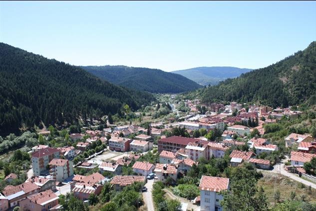
Azdavay is a district located in the northwest of Kastamonu, with forested and rugged terrain. The district's economy is based on agriculture, animal husbandry and forestry. There are various natural formations and historical structures in the district.
Azdavay (Azdavay Mufti's Office)
Azdavay district gained district status with the law numbered 4869 dated 12 February 1945 and was established as a district of Kastamonu province as of 1 April 1946. Before this date, Azdavay was a sub-district center of Daday district, but due to its distance from Kastamonu city center and its low economic dependence on Daday, it became an independent district. Azdavay's history dates back to ancient times. Archaeological findings in the region show that Paphlagonians lived here in the 8th century BC. Throughout history, Azdavay and its surroundings came under the rule of various civilizations such as the Hittite, Cimmerian, Persian, Hellenistic Pontus Kingdom, Roman Empire and Byzantine Empire in different periods. During the period of Candaroğulları (İsfendiyaroğulları) Principality that ruled Kastamonu and its surroundings in the 13th century, Azdavay was governed as one of the 36 judgeships of Kastamonu Sanjak. With the conquest of Kastamonu by the Ottoman Sultan Mehmed the Conqueror in 1460, Azdavay was annexed to the Ottoman lands.
In the Ottoman administrative structure, Azdavay remained a sub-district (kadilik) attached to the Daday district for a long time. When Daday gained district status in 1868, Azdavay was also administered as a sub-district attached to Daday; it became an administrative unit of Kastamonu when it became a district in 1946. Later, some changes occurred in its administrative borders. In 1988, 26 villages in the west of Azdavay were separated and a separate district named Pınarbaşı was established, and this division reduced the number of villages and population of Azdavay. Similarly, when its eastern neighbor Ağlı town was also made a district, the number of villages in Azdavay decreased considerably and today it has 49 villages. The district center consists of four neighborhoods named Merkez, Karşıyaka, Bahçelievler and Yenimahalle. No historical artifact from the Ottoman period has survived to the present day in Azdavay. However, the legends told among the people about the origin of the district name have taken their place in the local culture.
Azdavay is located in the Western Black Sea Region of Türkiye, in the northwestern part of Kastamonu Province. Its surface area is approximately 840 km² and its terrain is rugged and largely forested. The altitude of the district center is 830 meters. Its climate, which has continental characteristics, is quite harsh; winters are long and snowy. In winter, especially at night, the air temperature can drop to -20°C. Spring and autumn are cool and rainy. In summer, the temperature is around 25°C on average.
Azdavay is neighboring with Doğanyurt to the north, Şenpazar to the northwest, Pınarbaşı to the west, Daday to the south, Ağlı to the east and Küre to the northeast. The main stream starting in the east of the district and flowing westward is Devrekani Stream; this stream turns north at Hacet Kayası location, enters the lands of Cide district and flows into the Black Sea. Kocaçay and Valay Streams are also other important streams in Azdavay. Although most of the land is pastures and agricultural land, approximately 64% of the district is covered with forests. Deciduous trees and maquis species dominate the low parts of the forested areas, while coniferous trees dominate the higher parts. Tree species such as fir, pine, juniper, beech, oak, elm, poplar, linden, hornbeam, ash, wild hazelnut, plane tree, alder and willow in the district; Shrub species such as boxwood, wild cherry, rhododendron (avu), privet, tamarisk, blackberry, cornel (kiren) and bearberry grow naturally. The wild hazelnut species called "rock hazelnut" seen in the region attracts attention with its very hard shell and delicious kernel; the timber of this tree is used in furniture making. Azdavay is located within the Küre Mountains range and forms an important part of the Küre Mountains National Park thanks to its virgin forest texture and rich biodiversity. The natural structure of the district is also rich in terms of wildlife.
The total population of Azdavay district was 7,878 in 2007, but decreased to 7,462 in 2024. During this period, increases of 190, 398 and 798 people were observed in 2012–2013, 2017–2018 and 2022–2023, respectively; and decreases at varying rates were observed in other years. According to 2024 data, the male population is 3,796 (50.87%), the female population is 3,666 (49.13%), and the difference between the sexes generally remains at a scale of a few hundred people. Annual population changes have followed a fluctuating course that can be explained by various factors such as local record updates and migration movements.
Azdavay's economy is based on agricultural and forest products, and there is no significant industrial facility within the district borders. For this reason, livelihoods have been limited, and Azdavay has been a district that has been constantly migrating for many years. A significant portion of the district's population has migrated to large cities, primarily Istanbul, due to job and livelihood opportunities. As a result of this migration phenomenon, the village population has decreased; some villages have almost completely emptied, and village schools have closed due to the lack of students. Azdavay's demographic structure is gradually aging, and the decrease in the young population makes it difficult to diversify economic activities.
The current economic activities in the district are based on small-scale mining, forestry, animal husbandry, garment production and limited agriculture and greenhouse farming. Mines operated by the private sector (especially marble quarries) provide employment, albeit small. Forest management and the production of forest products (timber, etc.) have an important place in the economy thanks to the rich forest assets of the region. Although families in the region traditionally engage in grain farming and animal husbandry for their own needs, the population continuing these activities has decreased with the migration of the young population. Although new methods such as greenhouse farming (greenhouse farming) have been tried in recent years, production in this area is still in the development stage. In general, the lack of industrial investment and large enterprises has led to a slow economic development in Azdavay; due to this situation, the district has exhibited an appearance that is calm and largely preserves its traditional structure in social and cultural terms.
Its rich natural beauty and cultural values make Azdavay attractive in terms of tourism. One of the most important natural destinations of the district is Çatak Canyon, which is approximately 7 km from the district center. The canyon, which is reached by vehicle for approximately 6 km and by path for the last 1 km, is known for its steep geography. Çatak Canyon attracts visitors with its landscapes and the glass observation terrace built on the canyon in recent years. Watching the canyon view from the glass terrace, especially at sunset, is one of the highlights of tourism experiences in the region.
Apart from Çatak Canyon, there are also many caves and waterfalls within the borders of Azdavay. Another important element of the district's natural heritage is the approximately 740-year-old monumental pine tree located in Hoca village of Azdavay. This giant pine tree, known as the Hoca Village Monument Tree, has been registered and protected by the Ministry of Agriculture and Forestry of the Republic of Turkey. The monumental tree, which has picnic tables and walking areas around it, offers a wide view and is visited by local and foreign tourists. One of the cultural symbols of the district is the Lovers' Bridge. This bridge, which connects the Azdavay district center and Karşıyaka Neighborhood over the Devrekani Stream, was first built with wood approximately one and a half centuries ago. After the old bridge was demolished in 1987, a steel-cable suspension bridge was built in its place and it continued to be called the Lovers' Bridge. According to legend, it takes its name from the story of two lovers who met here and decided to jump off the bridge together because their marriage was prevented. Today, the Lovers' Bridge and its surroundings have been turned into a recreation area by the Azdavay Municipality and are used as a resting point for the public and visitors during the summer months. Azdavay also benefits from the ecotourism opportunities offered by the Küre Mountains National Park and has suitable areas for activities such as nature walks, camping and photography.
The traditional culture of Azdavay also has an important place in the identity of the region. The Azdavay local costume worn by women in the district in daily life is a garment with a history of approximately 600 years. This garment, which has been passed down from mother to daughter and from mother-in-law to bride and has survived to the present day, refers to a colorful traditional clothing set consisting of pieces such as a robe, apron, long johns, skullcap (headgear) and headscarf. The women's clothing specific to the Azdavay region was recently registered with a geographical indication by the Turkish Patent and Trademark Office, and thus, for the first time in Türkiye, a local garment received a geographical indication certificate. In this way, the protection of the local costume and its transfer to future generations has been officially secured. Today, Azdavay women continue to wear this clothing in every aspect of life, from field work to home life.
Folk dances and games known as Azdavay games, which are part of the local folklore, are also performed with traditional costumes. Folk dance teams perform these games, which reflect the district's culture, at festivals and events, thus keeping the intangible cultural heritage alive. Since modernization and urbanization have been relatively slow in Azdavay, traces of the traditional way of life can still be seen. For example, although the tradition of the village room, which was present in every village settlement in the past and served as a place to host guests during weddings and holidays, has largely disappeared, some villages are attempting to revive it by rebuilding it. Such initiatives are part of efforts to keep the district's cultural values alive.
Azdavay cuisine is a part of the traditional food culture of the Kastamonu region. The dietary habits in the region are based on cereal products, legumes, meat and dairy products and forest plants, depending on the climate and geography. Traditional dishes such as etli ekmek (meat bread), banduma and ekşili pilaf, which are unique to Kastamonu, are also included in Azdavay tables. In addition, beekeeping has developed thanks to the rich vegetation of the region, and aromatic highland honey obtained from the pollen of various flowers is one of the products unique to the region. This natural honey is consumed by the people of the district and marketed outside the province. Dairy products such as butter and cheese, which are produced in the region using traditional methods, and agricultural foods have an important place in Azdavay cuisine.
Presidency of Religious Affairs of the Republic of Turkey Azdavay Mufti's Office. "Azdavay District Introduction and History." Azdavay Mufti's Office. Access date: May 12, 2025. https://kastamonu.diyanet.gov.tr/azdavay/Sayfalar/contentdetail.aspx?MenuCategory=Kurumsal2&ContentId=muftulugumuz
Republic of Turkey Ministry of Culture and Tourism Kastamonu Provincial Directorate of Culture and Tourism. “Azdavay.” Kastamonu Provincial Directorate of Culture and Tourism . Access date: May 12, 2025. https://kastamonu.ktb.gov.tr/TR-63811/azdavay.html
TC Azdavay District Governorship. “Lovers Bridge.” Azdavay District Governorship . Access date: May 12, 2025. http://www.azdavay.gov.tr/asiklar-koprusu
TC Azdavay District Governorship. “History.” Azdavay District Governorship . Access date: May 12, 2025. http://www.azdavay.gov.tr/tarihi
Turkish Statistical Institute (TurkStat). Address Based Population Registration System Results, 2024. Access date: April 20, 2025. https://data.tuik.gov.tr/Bulten/Index?p=Adrese-Dayali-Nufus-Kayit-Sistemi-Sonuclari-2024-53783
Azdavay (District)
Province(s) | Kastamonu | ||||||||
|---|---|---|---|---|---|---|---|---|---|
Area(s) | Black Sea | ||||||||
Altitude | 830 m | ||||||||
Population (2024) | 7.462 | ||||||||
Mayor(s) | Cevat Taskan | ||||||||
District Governor | Yakup Haciismailoglu | ||||||||
Postal Code | 37750 | ||||||||
License Plate Code | 37 | ||||||||
Climate(s) | Harsh continental climate | ||||||||
Economy | Agriculture forestry animal husbandry | ||||||||
History
Geography and Climate
Population and Demography
Economy
Tourism, Culture and Cuisine
This article was created with the support of artificial intelligence.