This article was automatically translated from the original Turkish version.
+1 More
Almus Dam Lake
Location | Tokat Almus | ||||||||
|---|---|---|---|---|---|---|---|---|---|
Type | Zonal Earth Fill | ||||||||
Opening to Operation | 1966 | ||||||||
Function | Energy, Irrigation, Fishing, Tourism | ||||||||
Surface Area | 3130 ha | ||||||||
Type | Artificial Dam Lake | ||||||||
Location | Almus, Tokat (Central Black Sea Region) | ||||||||
Surface Area | 3.130 hectares (ha) | ||||||||
Elevation | 832 meters | ||||||||
Feeding River | Yeşilırmak | ||||||||
Purposes | Agricultural irrigation, energy production, cage trout farming, water sports and tourism | ||||||||
Purposes | Agricultural irrigation Energy production Cage trout farming Water sports and tourism | ||||||||
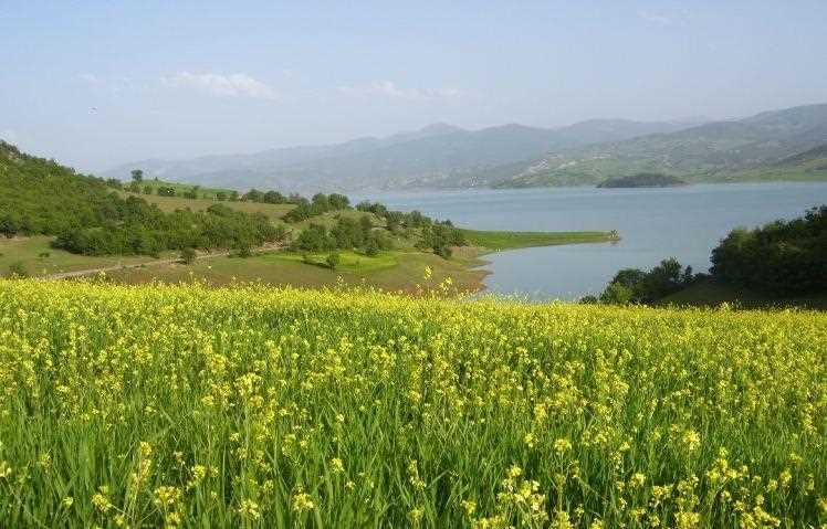
Almus Dam Lake is an artificial lake located on the Yeşilırmak River in the Almus district of Tokat Province, within Türkiye’s Central Black Sea Region. It is utilized for agricultural irrigation, electricity generation, cage trout farming, and tourism. The lake formed at the point where the Yeşilırmak makes a slight bend before entering the Omala Plain gorge.
The lake is situated approximately 36 kilometers from the center of Tokat Province. Its geographic coordinates lie between 40 degrees 22 minutes north latitude and 36 degrees 55 minutes east longitude. With an elevation of 832 meters above sea level, the lake has a total surface area of 3,130 hectares.
The lake’s climate exhibits transitional characteristics between the regions influenced by the Black Sea and the continental climate of Central Anatolia. Precipitation is generally distributed throughout the year, with an annual average rainfall of 5,442 millimeters. The highest rainfall occurs in January, February, March, April, and May, while the lowest rainfall is recorded in July and August.
The area where the lake bed was formed lies on the most fertile lands of the district. Toward the lower parts of the valley, the rock structure consists of homogeneous, massive, fine-grained andesitic lavas. Above these massive andesites, layered formations dominate, containing lava flows, breccia, conglomerate, and tuff.
The lake was created by the construction of the Almus Dam on the Yeşilırmak River. The dam body is designed as a zoned earthfill structure, and water retention began on October 1966.
Almus Dam Lake (Cultural Portal)
The volume of water and fill level in the dam lake vary significantly throughout the year depending on seasonal rainfall, snowmelt, and usage demands. During spring, when snow in the mountains melts and rivers swell, approximately 12 million cubic meters of water enter the lake daily. In contrast, the daily water discharge from the lake is around 2.5 million cubic meters.【1】
The fill level, which stood at 38 percent at the beginning of January, rises to 82 percent by the end of April due to winter and spring rainfall.【2】 During dry periods with low rainfall, temporary islands emerge on the lake surface; these islands are submerged again when rainfall increases.
During summer months, water withdrawal from the lake for agricultural irrigation, electricity generation, and evaporation causes the “Left Bank Group Road” within the lake bed to become exposed. This stabilized route, implemented in 2022 through a joint initiative of the Almus District Governorship, municipality, town municipalities, and village headmanships, has the following features:
Almus Dam Lake (Cultural Portal)
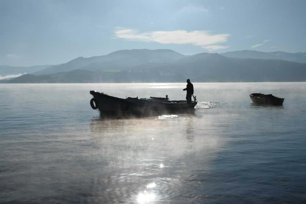
The lake serves as a strategic center for cage trout farming. During periods of abundant snowmelt and rainfall, increased water levels elevate oxygen concentrations, promoting rapid trout growth. In addition to commercial production areas, the bays formed by the lake are widely used for recreational angling.
The lake’s surroundings are entirely covered by forest, and its shoreline features numerous natural coves. The lake surface provides an ideal course for water sports. Swimming in the lake during summer is one of the region’s most popular activities.
Along the lake shore, small restaurants operated by local trout producers offer a “catch and cook yourself” dining experience. The main recreational areas, visited almost daily by residents of Almus as well as tourists from neighboring provinces (Sivas, Amasya, Çorum) for picnics, include:
Anadolu Ajansı. "Almus Baraj Gölü'nde doluluk yüzde 82'ye ulaştı." Accessed May 12, 2026. https://aa.com.tr/tr/gundem/almus-baraj-golunde-doluluk-yuzde-82ye-ulasti/3925516
Anadolu Ajansı. "Tokat'ta baraj yatağı içinde bulunan yol suların çekilmesiyle kullanılabiliyor." Accessed May 12, 2026. https://www.aa.com.tr/tr/gundem/tokatta-baraj-yatagi-icinde-bulunan-yol-sularin-cekilmesiyle-kullanilabiliyor/3661144
T.C.Almus Kaymakamlığı Governorship. "Genel Coğrafya ve Yeryüzü Şekilleri." almus.gov.tr. Accessed May 12, 2026. https://www.almus.gov.tr/genel-cografya-ve-yeryuzu-sekilleri
Türkiye Kültür Portalı. "Almus Baraj Gölü - Tokat." T.C. Kültür ve Turizm Bakanlığı. Accessed May 12, 2026. https://www.kulturportali.gov.tr/turkiye/tokat/gezilecekyer/almus-baraj-golu
[1]
Anadolu Agency, "Almus Dam Lake Fill Level Reaches 82 Percent," Anadolu Agency, Access Date: 12 May 2026,
https://aa.com.tr/tr/gundem/almus-baraj-golunde-doluluk-yuzde-82ye-ulasti/3925516
[2]
Anadolu Agency, "Almus Dam Lake Fill Level Reaches 82 Percent."
Almus Dam Lake
Location | Tokat Almus | ||||||||
|---|---|---|---|---|---|---|---|---|---|
Type | Zonal Earth Fill | ||||||||
Opening to Operation | 1966 | ||||||||
Function | Energy, Irrigation, Fishing, Tourism | ||||||||
Surface Area | 3130 ha | ||||||||
Type | Artificial Dam Lake | ||||||||
Location | Almus, Tokat (Central Black Sea Region) | ||||||||
Surface Area | 3.130 hectares (ha) | ||||||||
Elevation | 832 meters | ||||||||
Feeding River | Yeşilırmak | ||||||||
Purposes | Agricultural irrigation, energy production, cage trout farming, water sports and tourism | ||||||||
Purposes | Agricultural irrigation Energy production Cage trout farming Water sports and tourism | ||||||||
Geographical Structure and Climate Characteristics
Hydrological Status and Seasonal Variations
Left Bank Group Road on the Lake Bed
Economic Activities and Tourism
Tourism, Recreation, and Water Sports
