
Çatak Canyon is a canyon located in the Azdavay district of Kastamonu province, formed as a result of water erosion. It is a deep valley formed by the long-term erosion activities of rivers and streams.
Geographical Features
Çatak Canyon is a geological formation between the Azdavay and Pınarbaşı districts on the Devrekani River, one of the important rivers of the Western Black Sea Region. The canyon, starting near the Çatak Neighborhood of Ahat village in Azdavay district, extends approximately 8 kilometers in a southeast-northwest direction. The canyon, which reaches a depth of 900 meters in places, has narrow and steep slopes. The waters flowing from the canyon empty into the Çatak 1 and Çatak 2 branches. These branches are among the long rivers of Kastamonu. The total length of the canyon on its north and south sides is approximately 6 kilometers.
Glass Viewing Terrace
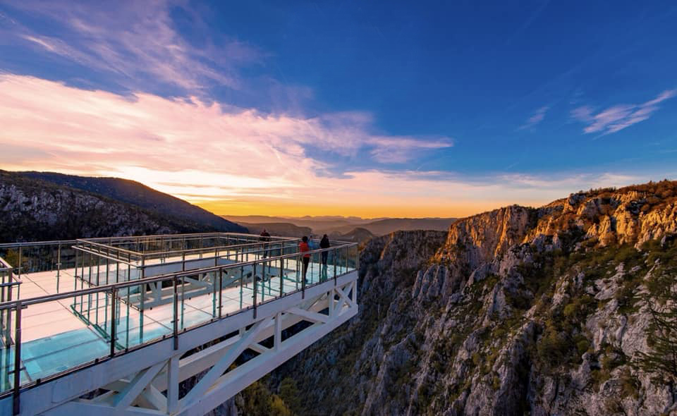
Çatak Canyon Glass Viewing Terrace, opened to visitors in September 2017 by Azdavay Municipality to observe the canyon landscape, is located on the eastern slope of the canyon, between Çaldağ (1340 m) and Ortaköknarlık hill (1303 m). The distance from the terrace to Azdavay center is 7 km, to Pınarbaşı district center is 22 km, and to Kastamonu city center is 108 km. The terrace has a position where a large part of the canyon can be observed from a bird's-eye view. The glass viewing terrace, built on a steel structure, has a total length of 33 meters and a width of 10 meters. 15 meters of this extends over the canyon void. The terrace, which weighs approximately 25 tons of metal and 10 tons of glass, has a total weight of approximately 60 tons in the void. The load of the approximately 18-meter steel structure in the rear section resting on the rock ground, encased in concrete and wrapped with construction rebar, is 900 tons. It has a capacity of 250 people. The height of the section where the terrace is built from the riverbed is 450 meters.
Çatak Canyon (Kastamonu Municipality)
Natural Beauties and Tourism Potential
Çatak Canyon is one of the tourist attractions of Kastamonu with its natural features and landscape. The 7-kilometer-long canyon void, vegetation, and wildlife can be observed from the glass terrace. The section from 1-2 km below Çatak Bridge, the starting point of the canyon, to Nalbantoğlu village is uninterrupted and continues to İnönü. Çatak Canyon, located in the Küre Mountains National Park, is considered by some sources to be the 4th largest canyon in the world. Access to the canyon, which is 7 kilometers from Azdavay district center, is provided by a 6-kilometer road and then a 1-kilometer forest walking path. A panoramic view of the canyon can be seen from the observation point.