
İkizdere is a district in the Black Sea Region of Türkiye, affiliated with Rize province. It is located 56 km southwest of Rize city center, approximately 20 km from the Black Sea coast. Known for its natural beauties, historical structures, and cultural richness, the district is an important center, especially for tea cultivation and plateau tourism.
İkizdere (İkizdere Municipality)
History
The settled history of İkizdere is interwoven with layers of civilization in the valleys at the intersection of the Black Sea coastal mountains and the Kaçkar Mountain Range, extending back to ancient times. Due to its strategic location, the region has served as a continuous cultural and commercial crossroads, passing from Persian rule to the Kingdom of Pontus, and through Roman and Byzantine administrations.
The settlement, which was included in Ottoman administration with the conquest of the Trabzon Greek Empire by Sultan Mehmed the Conqueror in 1461, was then known as "Kuray-ı Seb’a," meaning "Seven Villages." This name indicated the community of seven villages in the region and made İkizdere a sub-district center within the sanjak organization. As a result of Rize being organized as a sanjak center in 1878, Kuray-ı Seb’a officially gained sub-district status; in the late 19th century, it continued to exist as an administrative unit within the Rize District, attached to the Lazistan Sanjak of the Trabzon Province.
Parallel to the course of World War I, the occupation of the region by Russian forces on 15 February 1916 led to a two-year period of administrative change. With the withdrawal of Russian troops on 11 March 1918, İkizdere rejoined Ottoman administration and, a short time later, became part of the administration of the Republic of Türkiye.
In the early years of the Republic, in 1933, the name "Kuray-ı Seb’a" was removed from official records and registered as "İkizdere." In 1945, the settlement, which was then made a sub-district of Güneyce (which was still the district center at the time), gained full district status affiliated with Rize in 1952.
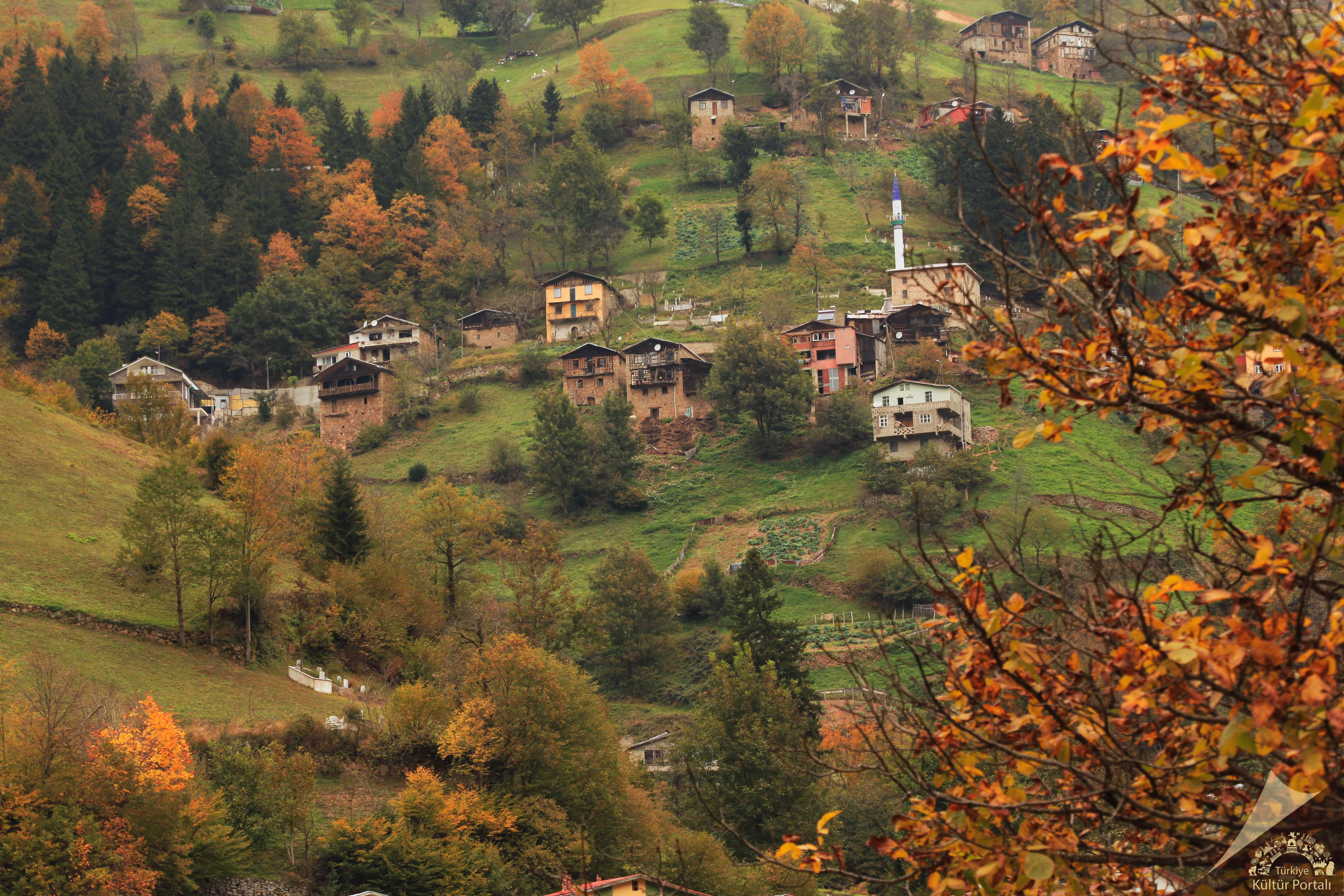
Today, İkizdere is one of the youngest districts of the Eastern Black Sea region, preserving traces of administrative changes from ancient times to the Republic with its stone bridges, wooden houses, and plateaus that witness the transition between the Black Sea and continental climates.
Geography and Climate
İkizdere is located in the northeast of Rize province, at the confluence of the Çamlık and Cimil streams; its area is 898 km², and the elevation of the district center is 570 m. The district, which has a mountainous and rugged terrain structure, draws attention with its lands fragmented by narrow valleys, high plateaus, and glacier-formed basins resembling crater lakes.
Due to its terrain structure, the streams formed in the valleys flow northward to reach the Black Sea directly. İkizdere (which originates from the confluence of the Çamlık and Cimil streams), the main water source, contributes to energy production with a small-scale hydroelectric power plant operating on it. Additionally, Karadere and its smaller tributaries play an important role in the region for both irrigation and drinking water supply.
In the high altitudes, Çağrankaya, Ovit, and Demirkapı plateaus are located, along with mineral water springs in Ilıcaköy and Şimşirli. These plateaus, with elevations reaching 1,800–2,500 m and a vegetation cover that changes with the season, offer opportunities for both settled life and tourism. Glacial troughs and small lakes found at the summits reveal the geomorphological diversity of the region.
In terms of climate characteristics, İkizdere is located in the typical Black Sea climate zone. High humidity and abundant rainfall are observed throughout the year (especially in autumn and spring months). The average rainfall exceeds 2,000 mm. This humid and mild climate creates suitable conditions for the growth of forest products, especially tea cultivation, in the lower sections.
The vegetation layers according to altitude:
- Low and medium altitudes (500–1,200 m): Broad-leaved forests such as hornbeam, alder, oak, and chestnut, as well as smaller shrub species, are common.
- High altitudes (above 1,200 m): Coniferous species such as spruce and fir, and alpine meadow-pasture clusters are observed.
These geographical and climatic features allow İkizdere to both preserve its natural structure, enabling forestry, hydroelectric energy, plateau life, and tea cultivation activities, and add a different value to regional tourism.
Population
According to 2021 data, the population of İkizdere is 1,875. The district has 1 municipality and 29 villages. A large part of the population resides in rural areas, and the traditional way of life still persists.
Economy
İkizdere's economy is based on a balanced combination of sectors determined by geographical and climatic conditions. While the rugged structure of the district's lands and narrow valleys limit areas suitable for large-scale agricultural activities, this situation has directed the local population towards a versatile livelihood model.
In the district, small ruminant (sheep, goat) and bovine (cattle) husbandry are a common source of livelihood within the traditional shepherding system. Professional knowledge, transferred through master-apprentice relationships, plays a role at every stage, from herd care to marketing. Seasonal grazing practices in high plateaus ensure both animal health and the preservation of plateau ecosystems. Furthermore, thanks to its floristic diversity, beekeeping is also an important sub-sector; İkizdere honey is sold through local branding processes, adding value to the regional economy.
A large part of İkizdere's area is covered with dense forests. These forests constitute a source area where basic forest products such as logs, lumber, and charcoal are produced. Planned cuttings carried out in cooperation with local cooperatives and the Forest Management Directorate, besides creating employment, also transfer regular income to the district budget. Furthermore, local spruce, fir, and hornbeam logs respond to the increasing demand of the sawdust industry.
There is a small-scale hydroelectric power plant (HES) on the İkizdere River, formed by the confluence of the Çamlık and Cimil streams. This facility meets a part of the region's electricity needs while providing a slight saving in energy prices for the local people. Additionally, the commercial utilization of mineral water springs in Ilıcaköy and Şimşirli creates an additional source of income for the region and prepares the infrastructure for the development of balneotourism.
Products such as corn, potatoes, and small amounts of beans, cultivated through slope farming practices in narrow valleys, largely meet household needs. Tea cultivation is carried out in limited areas close to sea level in the district; this also provides economic vitality to the small number of tea batches produced. In recent years, local mushroom and medicinal plant gathering activities have also come to the forefront as a seasonal additional income option.
Tourism, Culture and Cuisine
İkizdere promises potential for ecotourism with its thousand shades of green and geomorphological diversity. Çağrankaya, Ovit, and Demirkapı plateaus offer suitable infrastructure for day trips and overnight stays with their glacial lakes, waterfalls, and forest hiking trails. With the opening of the Ovit Tunnel, winter tourism opportunities have also expanded, making access to areas suitable for skiing and mountaineering easier. Furthermore, Ilıcaköy, where mineral water springs are located, is strengthening the health tourism alternative with the establishment of facilities for balneotourism.
İkizdere's culture, shaped by plateau life, includes social rituals woven around the shepherding tradition. Plateau festivals organized during the summer season reinforce local ties with events featuring folk dances accompanied by horon, kemençe, and tulum, and handicraft stands. Traditional stone houses, wooden mosques, and cupolas represent the architectural heritage of the region. Furthermore, water mills, although neglected, hold a place in cultural memory as they were used for grinding grain in the past.
İkizdere cuisine combines the staple ingredients of the Black Sea with high-altitude touches:
- Collard greens and cornbread: Cabbage soup and bazlama made from corn flour are primary energy-giving dishes.
- Mıhlama (kuymak): Prepared with regional butter and local cheese, it is an indispensable breakfast item.
- Trout products: Trout, raised in cold, oxygenated streams, is served grilled or pan-fried.
- Mineral water cookies and fruit leather: Cookies kneaded with Ilıcaköy mineral water and fruit leathers are both local snacks and souvenirs.
- Pickle and jam varieties: Cranberry, blackberry, and mushroom pickles; jams prepared from plateau plants add color to the tables.