


This article was automatically translated from the original Turkish version.
+1 More
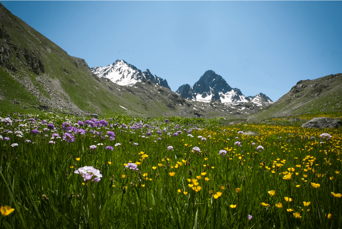
Kaçkar Mountains
Location | Rize and Artvin | ||||||||
|---|---|---|---|---|---|---|---|---|---|
Highest Point | 3,932 metres | ||||||||
Climate | snowy winters Black Sea climate – highly precipitous | ||||||||
Rivers | Fırtına Stream, Barhal Creek, Hemşin Stream | ||||||||
Biodiversity | broadleaf and coniferous forests; alpine meadows; endemic species | ||||||||
Wildlife | bear, lynx, wolf, roe deer, mountain eagle, chough, black vulture | ||||||||
Summer Pastures | Ayder, Pokut, Sal, Elevit, Amlakit, Hazindak, Dilberdüzü | ||||||||
Activities | mountaineering, trekking, highland tourism, photo-safari, birdwatching | ||||||||
Conservation Status | Kaçkar Mountains National Park (declared in 1994 – 52,970 hectares) | ||||||||
The Kaçkar Mountains are a mountain range located in northeastern Türkiye, within the Eastern Black Sea Region. They form the eastern extremity of the North Anatolian Mountains system, which runs parallel to the Black Sea coast. Rize Province’s Çamlıhemşin, Fındıklı, Ardeşen and İkizdere districts and Artvin Province’s Yusufeli district encompass these mountains, which are characterized by steep topography rising from the Black Sea coast toward the interior.
The highest point of the range is Kaçkar Mountain (Kaçkar Kavrun Peak) at 3932 meters elevation, making it the fourth highest mountain in Türkiye. Extending from the Verçenik Mountains in the west to the Altıparmak Mountains in the east, the Kaçkars present a complex topographic structure featuring numerous valleys, deep gorges and glacial features.

Kaçkar Dağları (Ekotaban)
The Kaçkar Mountains are a mountain system that rose during the Neotectonic period as part of the Alpine-Himalayan orogeny. The main geological units in the region consist of Paleozoic metamorphic rocks (schist, gneiss), Mesozoic marine sediments and volcanic rocks from the Paleocene–Eocene epochs.
Glacial features are still clearly visible in areas near the summit. Cirques, moraines, glacial valleys and small glacial lakes are common. It is one of the areas in Türkiye where glacial landforms are most distinctly observable.
The Kaçkar Mountains lie under the influence of a typical Black Sea climate. They receive consistent rainfall throughout the year; precipitation in areas near the coast can exceed 2500 mm. Temperature decreases with elevation and snowfall is prevalent for much of the year.
The region is a hydrological center for numerous rivers. The main rivers include:
The Kaçkars are among Türkiye’s most biodiverse regions. Vegetation varies across altitude zones as follows:
Wildlife is highly diverse. The fauna includes mammals such as brown bear, wild boar, wolf, roe deer, wild goat and chamois, as well as bird species such as bearded vulture, golden eagle and black vulture. Additionally, the Kaçkars lie along migration routes of numerous bird species traveling from Europe to the Middle East.
Rural life around the Kaçkar Mountains has long been intertwined with traditional transhumance. In particular, residents of Çamlıhemşin and Yusufeli migrate to high-altitude pastures during summer months. Temporary wooden houses and stone-based structures are found on these pastures.
Ayder, Pokut, Sal, Elevit, Amlakit, Hazindak, Yaylalar, Dilberdüzü are well-known pastures that hold cultural significance in the region. The area, predominantly inhabited by Hemshin and Laz communities, is also rich ethnographically in its music, traditional crafts and architecture.
Since the 1990s, the Kaçkar Mountains have become a major destination for both domestic and international tourists, alongside the growth of nature tourism in Türkiye. The region’s diverse natural landscapes, rich ecosystems and mountainous terrain make it suitable for a variety of outdoor activities.
Kaçkar Peak (3937 m) is considered one of Türkiye’s most technically challenging mountain routes. Mountaineering activities are concentrated during the summer months, particularly July and August. Summit ascents are typically completed over a three-day route. The route presents moderate technical difficulty; glacier crossings and high altitude make guided ascents advisable. The Kaçkars are also suitable for winter mountaineering, but require significant preparation due to snow and avalanche risks.
The Kaçkar Mountains host numerous hiking trails of varying difficulty levels. The most renowned trekking routes include:
Along the hiking trails, traditional pasture settlements, historic footpaths, glacial lakes and rich flora and fauna can be observed. The region’s unique flowering periods, particularly late June and early July, are favored by nature observers.
The Kaçkars are among the primary areas where the Black Sea transhumance culture remains active. Pastures such as Ayder, Pokut, Sal, Amlakit, Hazindak, Elevit and Palovit attract both local populations and tourists, especially during summer months. These pastures are notable for their traditional wooden architecture, festivals, regional cuisine and natural landscapes.
The Kaçkar Mountains are a valuable area for observation and photography due to their rich flora and fauna. Particularly:
attract both amateur and professional nature photographers.
The optimal period for wildlife observation is late spring to early summer. These observations along nature trails must be conducted in a controlled and low-impact manner.

Kaçkar Dağları (TürkiyeKültürPortalı)
Due to its high biodiversity, unique landscape values and traditional cultural structures, the Kaçkar Mountains were declared Kaçkar Mountains National Park on 31 August 1994. The national park covers an area of 52,970 hectares and is managed by the General Directorate of Nature Conservation and National Parks.
Within the protected area are high mountain ecosystems, alpine meadows, forest belts, glacial lakes, deep valleys and rare animal species. Additionally, the traditional transhumance culture, stone-based wooden structures and agricultural activities carried out during summer months are included in the conservation scope as cultural landscape values.
The national park status aims to limit uncontrolled urbanization and industrial investments while promoting sustainable tourism practices within a balance of conservation and use.
In recent years, the Kaçkar Mountains have faced significant environmental pressures due to various anthropogenic activities. These threats endanger both ecological balance and cultural heritage:
The region, rich in water resources, has been the subject of numerous small and medium-scale HPP projects. Particularly, HPPs planned or constructed along the Fırtına Valley, Hemşin Deresi and Barhal Valley alter river regimes, destroy habitats of endemic species and cause irreversible damage to valley ecosystems.
Road networks extending to pastures, constructed and widened with asphalt to improve tourism access, negatively impact natural topography. Cutting natural slopes increases landslide and erosion risks, while engineering practices incompatible with the terrain disrupt flora and fauna corridors. Vehicle connections between pastures have led to the disappearance of traditional hiking routes.
Mining exploration and operation permits issued in areas adjacent to the national park boundaries are concentrated especially in Artvin and Yusufeli. These permits for gold, copper and other metallic ores lead to direct deforestation, water pollution and habitat fragmentation. Geothermal exploration also exerts pressure on the regional ecosystem.
Tourism interest in the region has led to unplanned and uncontrolled development in some areas. In centers such as Ayder Pasture: reinforced concrete structures have increased, traditional architecture has been degraded and solid waste management has proven inadequate. Additionally, rising visitor numbers at pastures have caused vegetation damage, wildlife displacement and contamination of water sources.
Artvin Valiliği. "Kaçkar Yaylası ve Kaçkar Dağları Turizm Merkezi." Artvin Valiliği Resmî Web Sitesi. Accessed May 3, 2025.http://www.artvin.gov.tr/kackar-yaylasi-ve-kackar-daglari-turizm-merkezi.
Kackar.org. "Kaçkar Dağları - Forum." Accessed May 3, 2025.http://www.kackar.org/forum/viewtopic.php?t=41.
Kackar.org. “Kaçkar Dağları Hakkında.” Accessed May 3, 2025.http://www.kackar.org/.
Ministry of Agriculture and Forestry. "Kaçkar Dağları Milli Park Müdürlüğü." 12. Bölge Müdürlüğü Resmî Sitesi. Accessed May 3, 2025.https://bolge12.tarimorman.gov.tr/Menu/46/Kackar-Daglari-Milli-Park-Mudurlugu.
Ministry of Agriculture and Forestry. "Kaçkar Dağları Milli Parkı Alan Bilgileri." *Ekotaban*. Accessed May 3, 2025.https://ekotaban.tarimorman.gov.tr/alan/47.
Ministry of Culture and Tourism. "Kaçkar Dağları Milli Parkı." *Türkiye Kültür Portalı*. Accessed May 3, 2025.https://www.kulturportali.gov.tr/turkiye/rize/gezilecekyer/kackar-daglari-milli-parki.
TRT Anadolu Ajansı. “Kaçkar Dağları Milli Parkı.” Anadolu Ajansı Foto Galeri. Accessed May 3, 2025.https://www.aa.com.tr/tr/pg/foto-galeri/kackar-daglari-milli-parki/0.
TRT Anadolu Ajansı. “Kaçkar Dağları.” Anadolu Ajansı Foto Galeri. Accessed May 3, 2025.https://www.aa.com.tr/tr/pg/foto-galeri/kackar-daglari#!

Kaçkar Mountains
Location | Rize and Artvin | ||||||||
|---|---|---|---|---|---|---|---|---|---|
Highest Point | 3,932 metres | ||||||||
Climate | snowy winters Black Sea climate – highly precipitous | ||||||||
Rivers | Fırtına Stream, Barhal Creek, Hemşin Stream | ||||||||
Biodiversity | broadleaf and coniferous forests; alpine meadows; endemic species | ||||||||
Wildlife | bear, lynx, wolf, roe deer, mountain eagle, chough, black vulture | ||||||||
Summer Pastures | Ayder, Pokut, Sal, Elevit, Amlakit, Hazindak, Dilberdüzü | ||||||||
Activities | mountaineering, trekking, highland tourism, photo-safari, birdwatching | ||||||||
Conservation Status | Kaçkar Mountains National Park (declared in 1994 – 52,970 hectares) | ||||||||
Geological Structure and Morphological Features
Climate and Hydrography
Flora and Fauna (Biodiversity)
Settlement, Transhumance and Cultural Structure
Tourism
Mountaineering (Alpinism and Summit Ascents)
Trekking (Long-Distance Hiking Routes)
Pasture Tourism
Nature Observation and Photography
Conservation Status and Environmental Issues
Conservation Status
Environmental Threats
Hydroelectric Power Plant (HPP) Projects
Road Construction and Expansion Works
Mining Permits
Uncontrolled Tourism Activities