
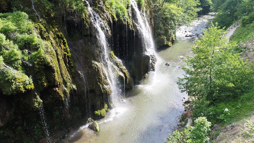
Kuzalan Waterfall is a waterfall located in Giresun province, in Türkiye's Black Sea Region. It is approximately 20 meters high. The waterfall flows over the Aksu Stream, from a slope with travertine formations. The travertines in the region were formed by the precipitation of calcium carbonate dissolved in groundwater. Kuzalan Waterfall is within the borders of Kuzalan Waterfall Nature Park. The region is being studied in terms of its geomorphological structure, hydrological features, and ecosystem.
Location
It is located within the borders of Dereli district of Giresun province, in Türkiye's Black Sea Region. The waterfall is positioned approximately 700 meters south of Kuzalan neighborhood, which is part of Alancık Village. Its distance to Giresun city center is approximately 45 kilometers. The region is located around the Aksu Stream valley along the Giresun-Dereli highway. This area, which is geomorphologically and hydrologically located in the inner parts of the Black Sea coastal zone, stands out with its steeply sloped valley structure.
Access to Kuzalan Waterfall is provided via the Giresun-Dereli highway. The road is suitable for vehicle traffic and follows the natural landscape of the valley. The roads facilitating access to the waterfall have been planned with attention to preserving the natural environment. Additionally, hiking trails and nature paths in the region offer various access alternatives to visitors.
Geological Features
The region is primarily composed of Paleozoic-aged granite and granodiorite rocks. The Aksu Stream valley and its surroundings have been shaped by the erosion and abrasion effects of these hard rocks. The area where the waterfall flows is a slope rich in travertine formations. Travertines are formed by the surfacing and precipitation of dissolved calcium carbonate in groundwater, and they are an important geological structural element here. These travertines are considered an indicator of the region's hydrogeological structure.
Geomorphological Structure
Kuzalan Waterfall and its surroundings have geomorphological features formed by the interaction of the valley floor, slopes, and streams. The waterfall is approximately 20 meters high, formed by the Aksu Stream flowing down a steep, travertine-covered slope. The valley slope, the morphology of the slopes, and the stream regime directly affect the appearance and formation process of the waterfall. The region also shows signs of severe erosion.
Kuzalan Waterfall (Anadolu Agency)
Climate Features
Kuzalan Waterfall is located in the Black Sea climate zone. The average annual temperature is approximately 13.6 °C. The warmest month is July, with an average temperature of 22.2 °C, and the coldest month is January, with an average temperature of 5.1 °C. The average annual precipitation is 1235.2 mm, and precipitation is relatively evenly distributed throughout the year. November is the wettest period. The region has high humidity, which positively affects the flora and fauna diversity.
Soil Structure
In and around the nature park, class VII and VIII lands are common. This classification implies limited suitability for agricultural production and a high risk of erosion. The soils are generally shallow, stony, and severely eroded. The most common soil type in the region is gray-brown podzolic soils. These soils are found in areas covered by forests, pastures, and partially hazelnut orchards.
Vegetation (Flora)
The area around Kuzalan Waterfall has a mixed vegetation cover, with both broad-leaved and coniferous trees. Spruce, beech, maple, elm, yew, wild hazel, and pure boxwood species form important plant communities. Some individuals are of monumental tree status in terms of age and size. This flora diversity indicates that the area is botanically valuable. The region is suitable for botanical tours and nature studies.
Animal Life (Fauna)
A wide variety of mammal, bird, reptile, rodent, and fish species live in the region. Mammals include species such as bear, roe deer, rabbit, wolf, fox, badger, weasel, stone and tree marten, ermine, and jackal. Birds include predators such as raven, falcon, hawk, golden eagle, eagle-owl, owl, and kite, as well as species like bittern, little egret, grey heron, crane, swan, duck, turtle dove, rock dove, partridge, and woodcock. Among reptiles, black snakes and docile snakes are common, while mice and squirrels are widespread among rodents. Natural trout, black fish, carp, and barbel species have been observed in Aksu Stream and its tributaries.
Human Environment
Kuzalan neighborhood is located as the closest settlement to the waterfall. The name of the neighborhood means "area remaining in the shade," and due to its geographical location within the valley, the duration of sunlight is short. The neighborhood experiences a temporary population increase in summer months; seasonal activities such as hazelnut harvesting become intensive. The population significantly decreases in winter months.
Cultural Features
Within the borders of the nature park, there are two historical wooden watermills. The mills were built with a log-pile system, and "hartama" (wooden shingles) were used on their roofs. These structures are architectural examples reflecting the traditional rural life and livelihood in the region. The historical mills were formerly used for grinding products obtained from corn farming.
Recreational and Scientific Use
Kuzalan Waterfall and its surroundings offer opportunities for recreational activities such as nature walks, wildlife observation, birdwatching, and photography. Furthermore, the region provides suitable environments for scientific research in disciplines such as flora, fauna, geology, and hydrology. In these respects, it holds potential for ecotourism activities.
Conservation Status
Kuzalan Waterfall is located within the boundaries of Kuzalan Waterfall Nature Park, and this area has been declared for the purpose of protecting natural resources and sustainable use. The management of the nature park is carried out within the framework of nature conservation principles, aiming to protect the ecosystem integrity.
Kuzalan Waterfall (Youtube/Giresun)