

This article was automatically translated from the original Turkish version.
+2 More
Location | Dolomite Point, Punakaiki, Paparoa National Park, New Zealand | ||||||||
|---|---|---|---|---|---|---|---|---|---|
Island it is located on | South Island | ||||||||
Geological Structure | Layered Limestone Mudstone | ||||||||
Formation Age | Approximately 30 million years | ||||||||
Formation Environment | Ancient Seafloor | ||||||||
Geomorphological Structure | Karst Coast Formation | ||||||||
Protection Status | Within Paparoa National Park | ||||||||
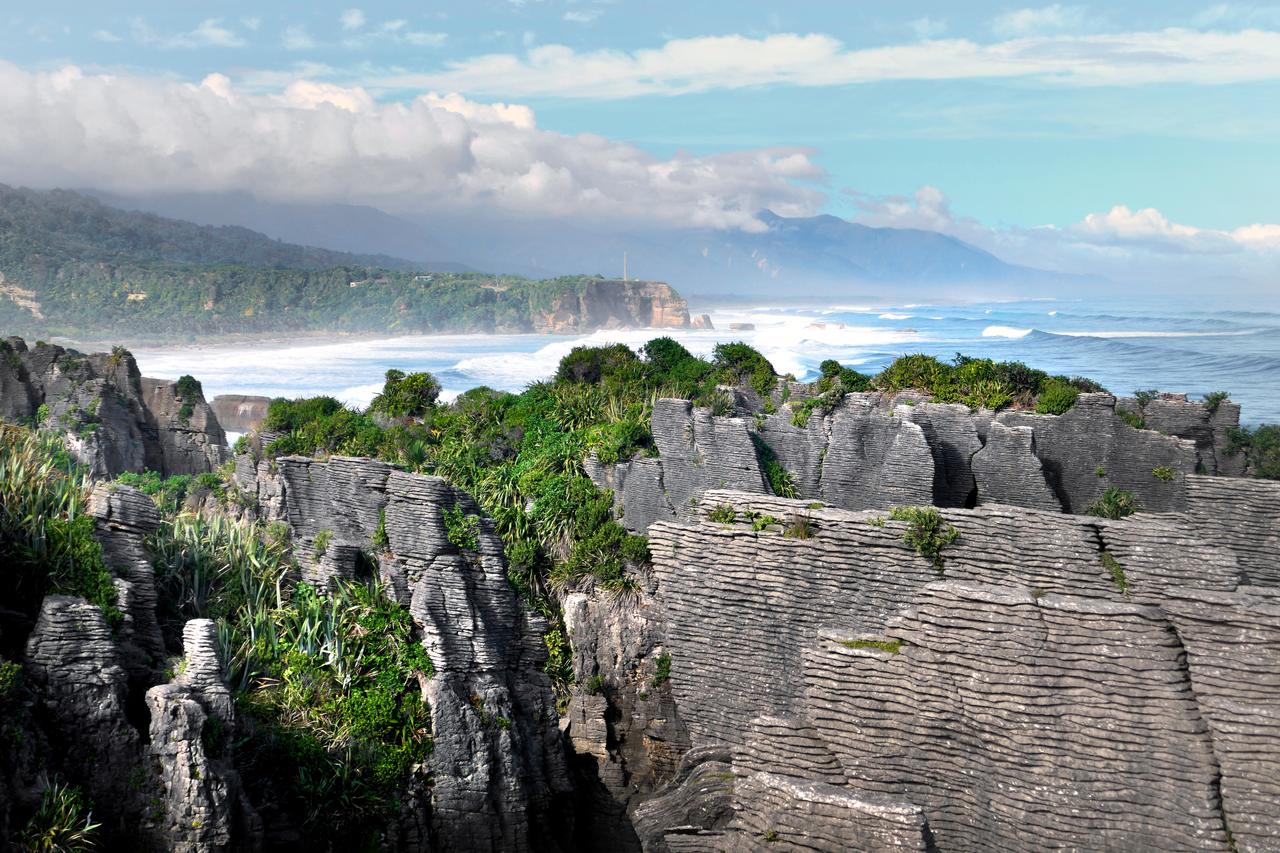
Pancake Rocks are a coastal geological formation located near Punakaiki within the boundaries of Paparoa National Park on the South Island of New Zealand. Characterized by layered limestone formations, the rocks at Dolomite Point exhibit a stacked pancake-like appearance due to the erosion of alternating thin mudstone layers and limestone strata. The layered rock structure, coastal erosion features, and blowholes make the Pancake Rocks one of the natural formations within Paparoa National Park.
Pancake Rocks (Flickr)
The Pancake Rocks are one of the limestone formations within the geological structure of Paparoa National Park. The region’s rock sequence consists of various geological units including granite sedimentary rocks coal layers limestone and mudstone. Sea level changes tectonic uplifts and prolonged erosion processes have been decisive in shaping the area’s current topography. As a result of these geological processes the limestone masses along the coast have developed a distinctive appearance and the Pancake Rocks have become one of the characteristic geomorphological features of the Paparoa coastline.
The formation of the Pancake Rocks is based on the lithification over approximately 30 million years of tiny particles from marine organisms and plants that accumulated on the seafloor. These materials deposited at depths of about two kilometers were compressed under high water pressure into alternating hard and soft layers forming limestone.【1】 Subsequent tectonic movements uplifted these limestone layers above sea level. Following uplift prolonged erosive effects from slightly acidic rainwater wind and seawater shaped the rocks producing the layered rock structure visible along the coast and the distinctive forms that characterize the Pancake Rocks today.
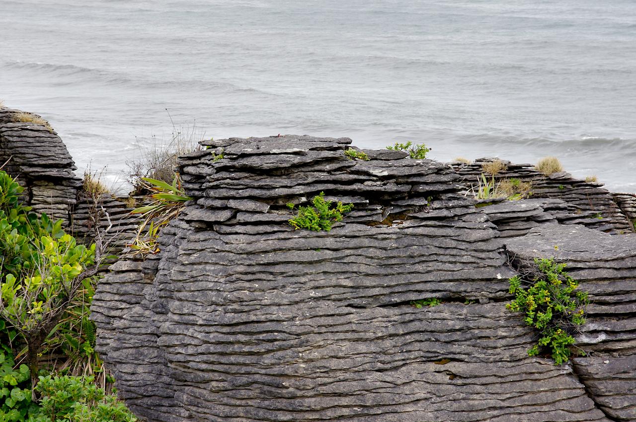
Pancake Rocks (Flickr)
The Pancake Rocks consist of durable limestone layers separated by thinner more mudstone-rich softer strata. This layered structure is the primary reason for their stacked pancake-like appearance. The limestone stacks at Dolomite Point have become more pronounced due to erosion of the softer layers resulting in a distinct banding pattern across the rock surfaces.
This type of bedding is known as stylolitic bedding (stylobedding) and is observed in limestone formations worldwide. It is believed to have developed during compaction rather than through original sedimentary layering. The combined effects of seawater wind and salt spray in the coastal environment have accentuated differences in resistance between layers eroding the rock surfaces and producing the layered structure that defines the Pancake Rocks.
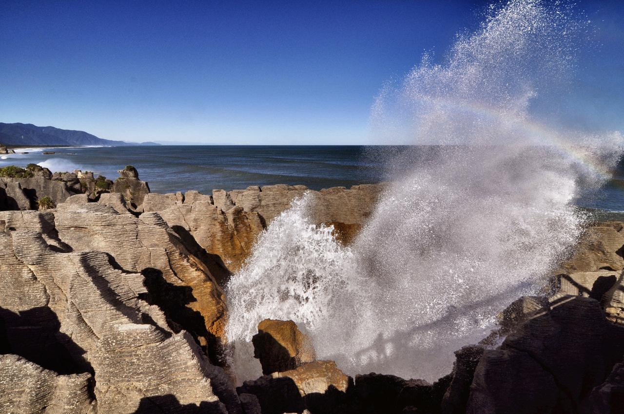
Pancake Rocks Blowholes (Flickr)
One of the most prominent natural features of the Pancake Rocks is the blowholes which are openings connected to cave and hollow systems beneath the rocks. During high tides ocean waves enter these cavities forcing water and air through narrow passages upward. This pressure causes water to erupt forcefully through openings on the rock surface. The height and intensity of these eruptions vary depending on tidal conditions and sea swell. Eruptions are particularly pronounced during high tides and strong waves coming from the southwest.
The blowholes are directly linked to cave systems formed by coastal erosion. Cavities created by the sea eroding the limestone masses gradually expanded and in some areas collapse of the ceilings formed funnel-shaped openings. These openings act as natural channels allowing seawater and compressed air to reach the surface. The blowholes around the Pancake Rocks are geomorphological features shaped by the interaction of layered limestone structures and coastal erosion processes.
The Pancake Rocks form part of the natural environment along the coast of Paparoa National Park. The region’s natural structure has developed within a coastal ecosystem shaped by the interaction of geological features and climatic conditions. Limestone formations the shoreline and surrounding natural areas combine to create a unique landscape. This environment constitutes an integrated natural system where coastal geomorphology and region-specific vegetation coexist.
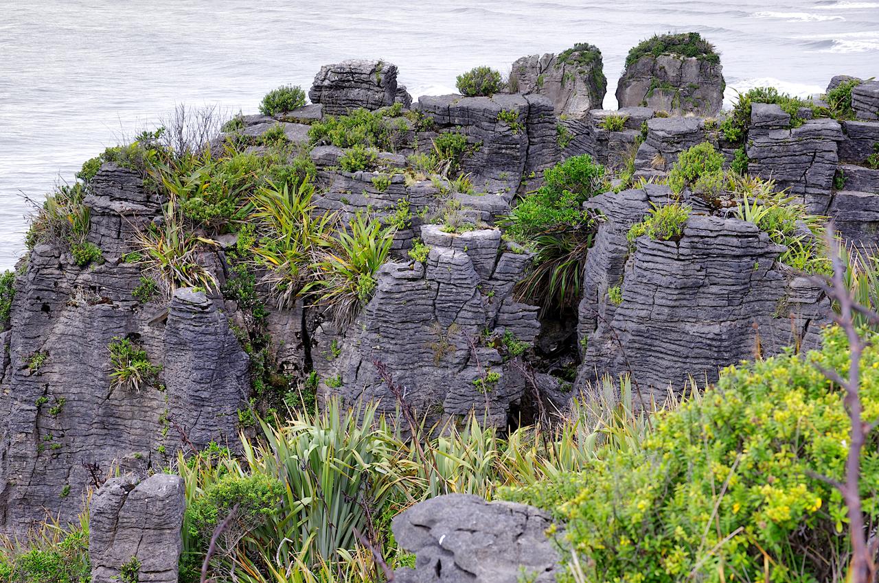
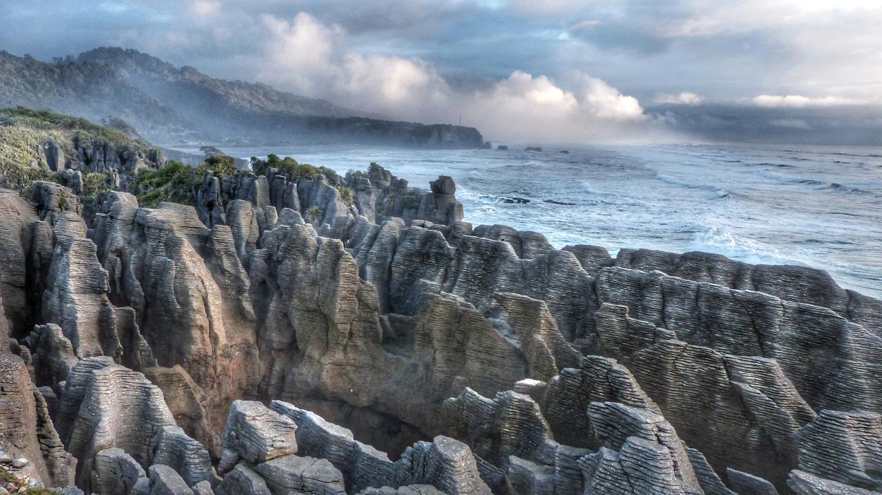
Pancake Rocks (Flickr)
The coastal area where the Pancake Rocks are located is characterized by steep cliffs rocky headlands coves and limestone formations extending along the shore. The erosive action of the sea has shaped the uplifted limestone masses over time contributing to the development of various geomorphological forms. The layered rock stacks at Dolomite Point are among the most prominent examples of uplifted limestone formations along the coast. Erosion processes have produced diverse coastal features such as wave-cut hollows caves and blowholes.
The Pancake Rocks form part of the widespread karst terrain in Paparoa National Park. High-purity limestone in the region has dissolved to form caves fissures and karren landforms. Along the coast differential erosion between limestone and mudstone layers has determined the current appearance of the cliffs. While dissolution dominates inland karst processes coastal erosion by waves is more prominent. The combined effect of these processes has shaped the coastal landscape where the Pancake Rocks are located.
Conservation and visitor management at the Pancake Rocks focus on preserving the natural formations the vegetation and visitor safety. Climbing on the rocks is prohibited and visitors are required to use designated walking tracks and not to cross safety barriers. These measures aim to protect nesting birds and rare Lepidium species growing on the coastal cliffs as well as reduce risks associated with hazardous coastal conditions.
Due to high visitor numbers the walking track at Dolomite Point has been upgraded along with bridges and other visitor infrastructure. Adjustments have been made in areas connected to the walking track to enhance safety and accessibility. At the Pancake Rocks one of the iconic visitor destinations in Paparoa National Park recreation use infrastructure improvements and access practices are implemented together to ensure that visitor experience is maintained alongside environmental protection.
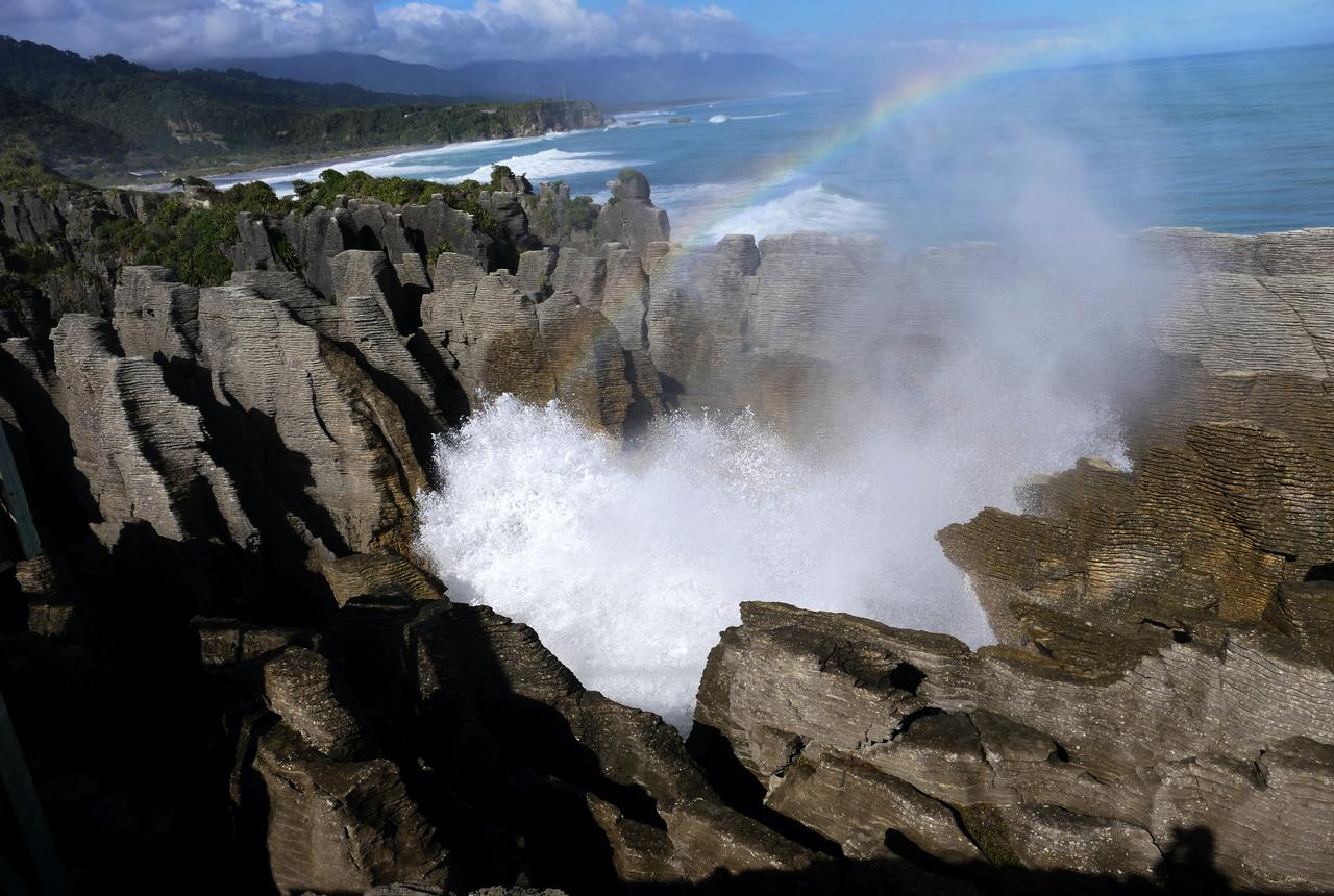
Pancake Rocks Blowholes (Flickr)
The Paparoa National Park where the Pancake Rocks are located holds special significance for the Ngāti Waewae community. The community’s connection to the land water and natural resources of the park is rooted in traditional relationships based on genealogical ties (whakapapa). Natural features in the region are regarded as integral parts of this relationship. The Pancake Rocks are not only one of the most recognized natural formations in Paparoa National Park but also symbolic elements of Punakaiki. Alongside the widespread nīkau palm they stand out as natural elements reflecting the region’s identity. This area visited and presented to visitors by the local community is an important component of Paparoa National Park’s natural and cultural landscape.
Chee.hong. “Punakaiki Pancake Rocks & Blowholes.” Flickr. Accessed July 2, 2026. https://www.flickr.com/photos/chleong/6885833836/
Helebrant, Jan. “Punakaiki Pancake Rocks.” Flickr. Accessed July 2, 2026. https://www.flickr.com/photos/96541566@N06/51989055981/
Helebrant, Jan. “Punakaiki Pancake Rocks.” Flickr. Accessed July 2, 2026. https://www.flickr.com/photos/96541566@N06/51989649550/
McSaveney, Eileen and Simon Nathan. “Pancake Rocks.” Te Ara – The Encyclopedia of New Zealand. March 2, 2009. Accessed July 2, 2026. https://teara.govt.nz/en/photograph/8320/pancake-rocks
New Zealand Department of Conservation. "Paparoa National Park Management Plan." New Zealand Department ofConservation Resmî Website. (2017): 1-140. Accessed July 2, 2026. https://www.doc.govt.nz/Documents/about-doc/role/policies-and-plans/national-park-management-plans/paparoa/paparoa-national-park-management-plan.pdf
New Zealand Department of Conservation. “Pancake Rocks and Blowholes Walk.” New Zealand Department of Conservation Resmî Web Sitesi. Accessed July 2, 2026. https://www.doc.govt.nz/parks-and-recreation/places-to-go/west-coast/places/paparoa-national-park/things-to-do/tracks/pancake-rocks-and-blowholes-walk/
Spragg, Bernard. “Blow holes Punakaiki.” Flickr. Accessed July 2, 2026. https://www.flickr.com/photos/volvob12b/52171003179/
Spragg, Bernard. “Pancake Rocks Punakaiki.” Flickr. Accessed July 2, 2026. https://www.flickr.com/photos/volvob12b/51378830843/
Spragg, Bernard. “Pancake Rocks Punakaiki.” Flickr. Accessed July 2, 2026. https://www.flickr.com/photos/volvob12b/55120186565/
Spragg, Bernard. “Pancake rocks. Westland.” Flickr. Accessed July 2, 2026. https://www.flickr.com/photos/volvob12b/52043613828/
Swarbrick, Nancy. “Pancake Rocks.” *Te Ara – The Encyclopedia of New Zealand*. August 1, 2015. Accessed July 2, 2026. https://teara.govt.nz/en/photograph/14448/pancake-rocks?__cf_chl_f_tk=tXa55MJt9RxoAveJe9RHxwBvcsS7ULQ4P4wZOY0Tccw-1783011733-1.0.1.1-x4CuRmw4k4xLEtw66tx2cUAYT8J1TFB2IdaHzXAxBOo
Urlich, Stephen, Janet Ward, and Ken Hughey. “Environmental Indicators of Tourism Impacts on Natural West Coast Assets, Aotearoa New Zealand.” Lincoln Üniversitesi Tourism Recreation Research and Education Centre (TRREC), (2001): 1-84. Accessed July 2, 2026. https://researcharchive.lincoln.ac.nz/server/api/core/bitstreams/22ef05f2-a83c-4c31-830d-98a730fb4678/content
[1]
New Zealand Department of Conservation, “Pancake Rocks and Blowholes Walk,” New Zealand Department of Conservation Official Website, Last Accessed: 2 July 2026, https://www.doc.govt.nz/parks-and-recreation/places-to-go/west-coast/places/paparoa-national-park/things-to-do/tracks/pancake-rocks-and-blowholes-walk/


Location | Dolomite Point, Punakaiki, Paparoa National Park, New Zealand | ||||||||
|---|---|---|---|---|---|---|---|---|---|
Island it is located on | South Island | ||||||||
Geological Structure | Layered Limestone Mudstone | ||||||||
Formation Age | Approximately 30 million years | ||||||||
Formation Environment | Ancient Seafloor | ||||||||
Geomorphological Structure | Karst Coast Formation | ||||||||
Protection Status | Within Paparoa National Park | ||||||||
Geological Formation
Formation Process
Stylolitic Bedding and Rock Structure
Blowholes
Natural Environment
Coastal Landscape and Karst Features
Conservation and Visitor Management
Cultural Significance