Bu içerik Türkçe olarak yazılmış olup yapay zeka ile otomatik olarak İngilizceye çevrilmiştir.
+1 Daha
Location | Ordu | ||||||||
|---|---|---|---|---|---|---|---|---|---|
Elevation(s) | 571 metres | ||||||||
Tourism and Site Status | First-Degree Natural Site Area First-Degree Archaeological Site Area | ||||||||
Historical Period | abandoned after Roman attacks. Hellenistic Period | ||||||||
Foundation | 3rd–1st century BC | ||||||||
Excavation Start | 2010 | ||||||||
Notable Discoveries | Necklace Keys Coins Water cistern 426-step tunnel Arrow and spearheads Bronze Herme Figure of Apollo Rhytons in the shape of goats Dionysus Marble Kybele Statue | ||||||||
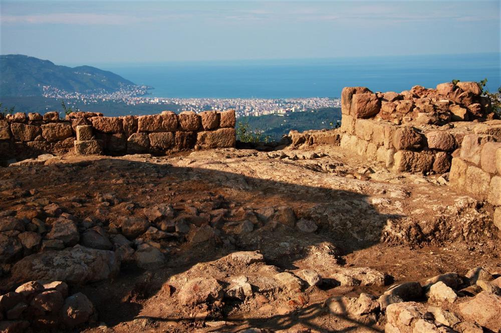
Kurul Kalesi is an archaeological and natural heritage site located within the boundaries of Bayadı Village, Altınordu District, Ordu Province, approximately 13 kilometers from the city center. It is situated on a sharp rock formation at an elevation of 571 meters above sea level, dominating the Melet River valley. The fortress extends along a ridge in a northeast-southwest orientation. Access to Kurul Kalesi is possible both on foot and by vehicle, and movement between spaces at different elevations within the site is facilitated by a staircase system of hundreds of steps uncovered through archaeological excavations. The topography of the region is characterized by abrupt elevation changes and sloping terrain.
Kurul Kalesi (Türkiye Culture Portal)
The first archaeological excavations at Kurul Kalesi were initiated in 2010 under the direction of the Ordu Museum Directorate and with scientific guidance from Professor Dr. S. Yücel Şenyurt, and continued in subsequent years. These investigations represent the first scientific excavations in the Black Sea region. The findings revealed that the settlement dates back to the 3rd century BCE, but its function as a fortress was established in the early 1st century BCE during the reign of Mithradates VI, the last ruler of the Kingdom of Pontus. The fortress was constructed during this period as a defensive garrison and also served religious and administrative functions. After the conflicts between the Kingdom of Pontus and Rome, the fortress was abandoned and remained unused for approximately 2,000 years.
Kurul Kalesi is surrounded by stone walls averaging 2.5 meters in thickness. The settlement consists of two main sections: the Inner Fortress (summit) and the Northeast Terrace. These two sections are connected by corridor-like passageways and entrance gates. Within the site, storage structures, religious spaces, and military rooms have been identified. A tunnel with 426 steps carved into the bedrock, forming part of the main access route, is architecturally significant. At the end of the tunnel lies a natural rock basin believed to have functioned as a water reservoir.
In addition to numerous baked clay tiles, ceramic fragments, metal objects, coins, and architectural elements, excavations at Kurul Kalesi have uncovered significant sculptures dating to the Hellenistic period. The 110-centimeter-tall, 200-kilogram marble statue of Cybele, discovered at the main entrance in 2016, is among the earliest known examples found in its original location in Anatolia. Additionally, figures of Dionysus and Pan, rhyta shaped like goats, a representation of Apollo, Hermes and eagle motifs, bronze keys, a necklace with a female head carved from onyx, arrow and spearheads, lamps, and other small finds have been recovered.

Archaeological Finds (Türkiye Culture Portal)
Kurul Kalesi holds both first-degree archaeological and first-degree natural heritage site status. All excavation and conservation activities conducted within the site have been carried out under the permits issued by the Ministry of Culture and Tourism. The eastern boundary of the site is defined by the Melet River, while the surrounding area features natural vegetation and forested zones. The regions outside the archaeological excavation area retain their natural and undisturbed landscapes.
The natural and cultural values of Kurul Kalesi have also been evaluated for recreational use. An analysis using the Güz method determined that the site’s recreational potential is rated at 55 percent suitability. Landscape value (21 percent), climate (15 percent), and accessibility (14 percent) exceed the average, while recreational convenience (7 percent) falls below average. Although the site currently has limited infrastructure due to ongoing excavations and its natural condition, it includes structured areas such as walking trails and viewing terraces.
Kurul Kalesi is an original settlement representing the archaeological and historical heritage of the Black Sea region. This structure, which played a role in the military and religious strategies of the Kingdom of Pontus during the Hellenistic period, provides significant insights into the region’s historical development through its preserved architecture and the artifacts uncovered during excavations. The site continues to hold importance for both scientific research and the preservation of cultural heritage.
Atabeyoğlu, Ömer, Kübra Nur Beyli, and Aslıhan Argan. “Karadeniz’in Arkeolojik Hazinesi Kurul Kalesi Rekreasyonel Alan Potansiyeli, Ordu.” *İnönü Üniversitesi Sanat ve Tasarım Dergisi* 7, no. 16 (2017): 126–140. Accessed July 9, 2025. https://dergipark.org.tr/tr/download/article-file/390371.
Ministry of Industry and Technology of the Republic of Turkey, Black Sea Region Development Agency (DOKAP). “Kurul Kalesi.” *karadeniz.gov.tr*. Accessed July 9, 2025. https://karadeniz.gov.tr/kurul-kalesi/.
Ordu Büyükşehir Municipality. “Kurul’dan Adeta Tarih Fışkırdı.” *ordu.bel.tr*. Accessed July 9, 2025. https://www.ordu.bel.tr/haber/kurul-dan-adeta-tarih-fiskirdi-47633.
Ordu İl Directorate of Culture and Tourism. "Kurul Kalesi Yerleşkesi (Altınordu/Ordu)." *ordu.ktb.gov.tr*. Accessed July 9, 2025. https://ordu.ktb.gov.tr/TR-130678/kurul-kalesi-yerleskesi-altinorduordu.html.
Şenyurt, S. Yücel, and Atakan Akçay. “Kurul Kalesi (Ordu) VI. Mithradates Dönemi Yerleşimi Üzerine Ön Değerlendirmeler.” *Seleucia VI, Olba Kazısı Serisi*, 2016, pp. 221–248. Accessed July 9, 2025. https://dergipark.org.tr/tr/download/article-file/1146770.
Şenyurt, S. Yücel, and Atakan Akçay. “Kurul Kalesi (Ordu) VI. Mithradates Dönemi Yerleşimi Üzerine Ön Değerlendirmeler.” *Seleucia VI, Olba Kazısı Serisi*, 2016, pp. 221–248. Accessed July 9, 2025. https://dergipark.org.tr/tr/download/article-file/1146770.
Location | Ordu | ||||||||
|---|---|---|---|---|---|---|---|---|---|
Elevation(s) | 571 metres | ||||||||
Tourism and Site Status | First-Degree Natural Site Area First-Degree Archaeological Site Area | ||||||||
Historical Period | abandoned after Roman attacks. Hellenistic Period | ||||||||
Foundation | 3rd–1st century BC | ||||||||
Excavation Start | 2010 | ||||||||
Notable Discoveries | Necklace Keys Coins Water cistern 426-step tunnel Arrow and spearheads Bronze Herme Figure of Apollo Rhytons in the shape of goats Dionysus Marble Kybele Statue | ||||||||
Henüz Tartışma Girilmemiştir
"Kurul Castle" maddesi için tartışma başlatın
Historical Development and Hellenistic Settlement
Architectural Structures and Artifacts
Sculptures and Other Archaeological Finds
Protection Status and Site Characteristics
Recreational and Touristic Potential
