This article was automatically translated from the original Turkish version.
Akkışla
Akkışla (District)
Province İt Belongs to | Kayseri | ||||||||
|---|---|---|---|---|---|---|---|---|---|
Year İt Gained District Status | 1987 | ||||||||
Area(s) | 546 km² | ||||||||
Elevation(s) | 1.330–1.370 m | ||||||||
District Governor | Engin Atilla | ||||||||
Mayor(s) | Ayhan Arslan | ||||||||
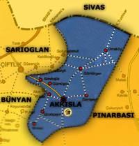
Akkışla is a district located in the eastern part of Kayseri, in Türkiye’s Central Anatolia Region. It is approximately 80 km from the provincial center. The district covers an area of 546 km² and lies at an elevation between 1,330 and 1,370 meters above sea level. It attained district status administratively in 1987. According to 2022 TÜİK data, the total population of the district is 5,563.
The Akkışla region has historically served as a settlement area for nomadic Turkic tribes. According to available sources, the first villages were established in 1804 by the Kuzugüdenli tribe of the Bayat branch of the Oğuz Turks, who settled at the foothills of Hınzır Dağı. At the time of its founding, the region comprised 45 villages; today it consists of 14 neighborhoods. Administratively, Akkışla was initially attached to Sivas Province and later, after Kayseri became a province, to the Pınarbaşı (Aziziye) district. Following Bünyan’s elevation to district status, Akkışla remained under its jurisdiction for a period; in 1953 a municipal organization was established, and on 19 June 1987, by Law No. 3392, it became an independent district. The name Akkışla derives from the white cliffs (“Ak”) to its north and its structure that allows animals to spend the winter outdoors (“Kışla”).
Akkışla is bordered by Pınarbaşı to the east, Sarıoğlan to the west, Gemerek (Sivas) to the north, and Pınarbaşı and Bünyan to the south. Approximately 60% of the district’s land is mountainous, while 40% is suitable for agriculture. The most significant elevation is Hınzır Dağı, characterized by steep slopes and deep valleys. The Acısu and Kesdoğan streams, which flow through the district’s boundaries, feed into the Kızılırmak River. There are no lakes or reservoirs in the region. The district experiences a continental climate, with hot and dry summers and cold, snowy winters. The vegetation is predominantly steppe. Mountainous areas feature pastures, meadows, and some forested zones. The district has 10,000 hectares of forest and 15,000 hectares of pasture and meadow land.
The district of Akkışla consists of three municipalities, one of which is the central municipality, and 14 neighborhoods. These neighborhoods are: Yeni, Yeşil, Şen, Yukarı, Uğurlu, Kululu, Akin, Gömürgen, Yeni Gömürgen, Alevkışla, Ganişeyh, Girinci, Gümüşsu, and Ortaköy. There is no court system in the district; judicial proceedings are handled by the Sarıoğlan Court. Major public institutions operating in the district include the District Governorship, Police Command, Gendarmerie Command, Directorate of National Education, Directorate of Agriculture and Forestry, Directorate of Population, Directorate of Health, Directorate of Land Registry, Agricultural Credit Cooperative, Muftiate, Meat Inspection Directorate, and a branch of Ziraat Bank.
Educational services in Akkışla are coordinated by the District Directorate of National Education. The district has four primary schools, four middle schools, one Multi-Program Anatolian High School, and a Community Education Center. The literacy rate was very low until 1937; today it has reached 93%. Of the population, 38% are primary school graduates, 28% are middle school graduates, 18% are high school graduates, and 6% have higher education. Health services are provided through the District Directorate of Health, the Community Health Center, and the Family Health Center. Health houses operate in the neighborhoods of Kululu, Gömürgen, and Ortaköy. The practice of summer migration to highland pastures (yayla culture) continues, particularly in Gömürgen Neighborhood, where residents still move their small livestock to highland pastures during the summer months. The district lacks cinemas, cultural centers, parks, or other social and cultural facilities; social life is generally revitalized during the summer months by contributions from expatriates returning from abroad.
Economic activities in Akkışla are primarily based on agriculture and animal husbandry. Production is largely oriented toward meeting household needs. Of the total 100,850 decares of arable land, 25,850 decares are irrigated and 75,000 decares are dryland. Crops such as wheat, barley, rye, oats, and chickpeas are cultivated on 59,600 decares. Additionally, 650 decares are used for sugar beet cultivation, 9,500 decares for forage crops, and 1,100 decares for fruit and vegetable production. Livestock farming includes approximately 3,290 head of large livestock and 45,000 head of small livestock registered in the district. Animal tagging and artificial insemination are practiced, and the establishment of milk collection centers has led to increased livestock activity. Commercial activities in the district are limited. A small number of food processing enterprises, a few blacksmiths, and carpentry workshops are operational. Agricultural and livestock products are generally marketed in Kayseri.
Accessed November 26, 2025.
Kayseri İl Directorate of Culture and Tourism. "Akkışla." *Republic of Turkey Ministry of Culture and Tourism Kayseri Provincial Directorate of Culture and Tourism*. Accessed July 15, 2025. https://kayseri.ktb.gov.tr/TR-54986/akkisla.html.
T.C.Akkışla Kaymakamlığı Governorship. “İlçemizin Tarihçesi.” Akkışla District Governorship Official Website. Accessed July 15, 2025. http://www.akkisla.gov.tr/ilcemizin-tarihcesi.
T.C.Kayseri Valiliği. “Akkışla.” *Kayseri Governorship Official Website*. Accessed July 15, 2025. http://www.kayseri.gov.tr/akkisla.
{'organization': 'Türkiye İstatistik Kurumu (TÜİK).', 'title': '"Türkiye İstatistikleri 2022." ', 'website': 'TÜİK Resmi Web Sitesi', 'date': 'June 2023.', 'accessed': 'Accessed July 15, 2025.'}
Akkışla
Akkışla (District)
Province İt Belongs to | Kayseri | ||||||||
|---|---|---|---|---|---|---|---|---|---|
Year İt Gained District Status | 1987 | ||||||||
Area(s) | 546 km² | ||||||||
Elevation(s) | 1.330–1.370 m | ||||||||
District Governor | Engin Atilla | ||||||||
Mayor(s) | Ayhan Arslan | ||||||||
History
Geographical Structure
Administrative Structure and Population
Social Structure and Education
Economy