This article was automatically translated from the original Turkish version.
+1 More

Balıklı Yaylası (Kültürportalı)
Location | Düzce Province Gölormanı Village | ||||||||
|---|---|---|---|---|---|---|---|---|---|
Elevation(s) | Approximately 1 400 meters | ||||||||
Area Size | Approximately 46 hectares | ||||||||
Topography | Flat meadow areas, forested environment, low slope | ||||||||
Forest Types | Oak, Hornbeam, Pine | ||||||||
Activities | Camping, Nature hiking, Photography | ||||||||
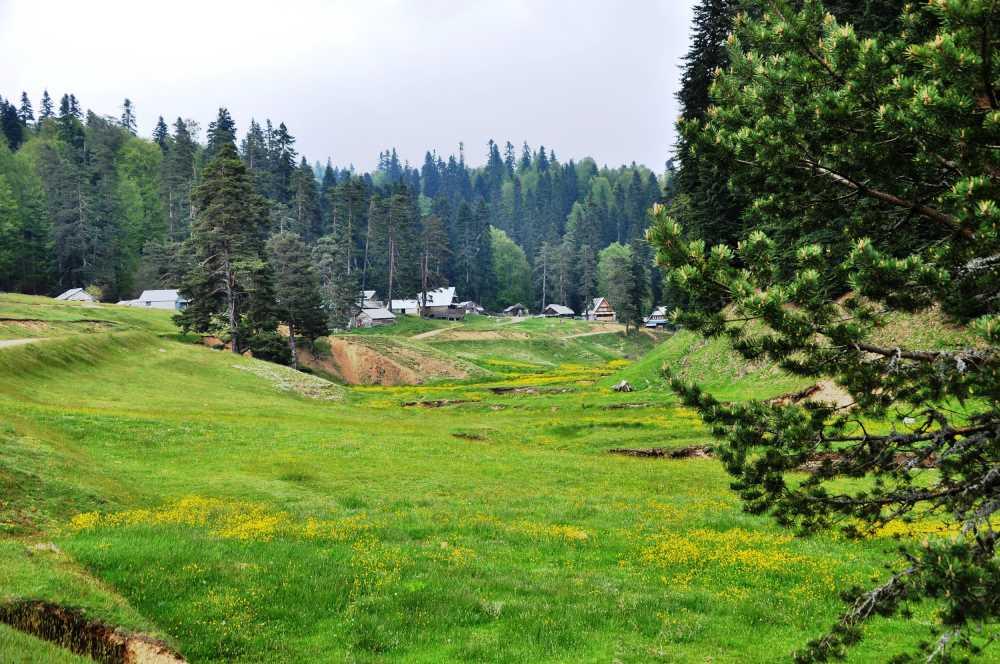
Balıklı Yaylası is a natural highland located within the boundaries of Gölormanı Village, under the district center of Düzce, at the foot of the Elmacık Mountains and at an elevation of approximately 1,400 meters. Covering an area of 46 hectares, the highland is notable for its expansive grasslands, dense forest cover, and natural water source flowing through it, making it a site of significant interest for both natural landscapes and recreational use.
Balıklı Yaylası is situated approximately 36 kilometers from the city center of Düzce. Access to the highland is achieved via road, following the route through Gölormanı Village. Positioned on the Elmacık Mountains range, the highland lies within the transitional zone between the Black Sea and Inner Western Anatolia climatic influences. Its high elevation and forested surroundings create a microclimate characterized by cool and humid conditions.
Balıklı Yaylası (Culture Portal)
The highland consists of gently undulating plains surrounded by forests, featuring wide grassy areas suitable for tent camping and hiking. The terrain is notable for its low slope and suitability for surface water flow. A stream running through the center of the highland shapes its hydrological structure and serves as a vital natural element supporting the continuity of the vegetation cover.
Balıklı Yaylası stands out due to its rich surrounding forest cover. Dominant tree species in the area include beech, hornbeam, and pine. The forest structure accommodates both broadleaf species adapted to high elevations and needleleaf species, thereby supporting biological diversity in the highland’s surroundings. Understory vegetation includes various herbaceous plants, ferns, and shrublands.

Balıklı Yaylası (Culture Portal)
The permanent stream flowing through the center of the highland defines its natural identity and serves as a crucial water source for local flora and fauna. Although a detailed biological inventory of fish species in this stream is not available, it is believed that the name of the highland derives from this watercourse. The presence of water facilitates visitors’ access to natural resources during camping and hiking activities.
Balıklı Yaylası offers various opportunities for nature-based activities:

Balıklı Yaylası (Culture Portal)
Balıklı Yaylası has no permanent infrastructure facilities such as toilets, electricity, or restaurants. This preserves the area’s natural character but requires visitors to bring their own equipment. Vehicle access is possible, though road conditions may vary seasonally due to unpaved sections. There are no directional signs or environmental information boards on-site.
Although the highland can be visited throughout the year, the most active visitation period is from late spring to early autumn. The cool climate during summer months makes it a preferred destination for campers and hikers. Winter months bring heavy snowfall, which can make access difficult. Seasonal transitions, particularly foggy weather and leaf fall, enhance the visual landscape value of the area.
T.C.Düzce İl Directorate of Culture and Tourism. "Balıklı Yaylası." T.C. Düzce Valiliği İl Kültür ve Turizm Müdürlüğü, Accessed July 9, 2025.
Turkish Ministry of Culture and Tourism. "Balıklı Yaylası." *Kültür Portalı*, Accessed July 9, 2025.

Balıklı Yaylası (Kültürportalı)
Location | Düzce Province Gölormanı Village | ||||||||
|---|---|---|---|---|---|---|---|---|---|
Elevation(s) | Approximately 1 400 meters | ||||||||
Area Size | Approximately 46 hectares | ||||||||
Topography | Flat meadow areas, forested environment, low slope | ||||||||
Forest Types | Oak, Hornbeam, Pine | ||||||||
Activities | Camping, Nature hiking, Photography | ||||||||
Geographical Location and Access Characteristics
Topography and Land Structure
Forest Formation and Vegetation Cover
Water Resources and Hydrographic Features
Recreational Use and Visitor Activities
Infrastructure and Facilities
Seasonal Conditions and Visit Periods