This article was automatically translated from the original Turkish version.
+1 More

Beypazarı
Earth | The northwestern part of Ankara is located along the old Ankara-Istanbul road. | ||||||||
|---|---|---|---|---|---|---|---|---|---|
Distance(s) | 98 to 100 km from Ankara. | ||||||||
Neighbors | Ayaş, Güdül, Nallıhan, Kıbrıscık, Çamlıdere, Polatlı, Mihallıçcık, Eskişehir, Gerede, Seben, Kızılcahamam. | ||||||||
Area(s) | 1.868 km² | ||||||||
Elevation(s) | 675 m | ||||||||
First Name | Lagania (Luwician: 'Land of the Rock Peak'). | ||||||||
Origin of the Name | Beypazarı, derived from the title of the Sipahi bey and the market, 'Beğ Bazarı', or from Germiyanoğlu's vizier Zinar Hezar. | ||||||||
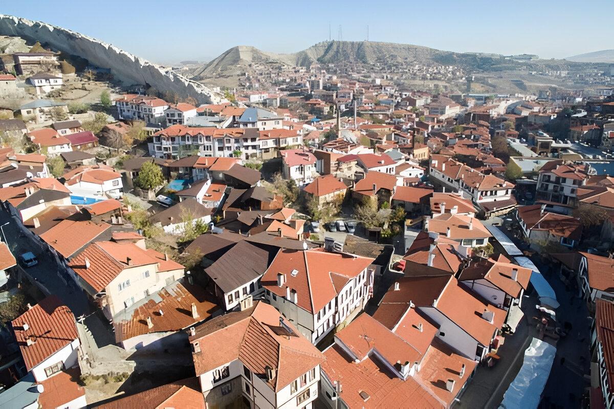
Beypazarı is a historic district located in the northwestern part of Ankara, along the old Ankara-Istanbul route, approximately 98 to 100 kilometers from the capital. It is bordered by the districts of Ayaş, Güdül, Nallıhan, Kıbrıscık, Çamlıdere, Polatlı, Mihallıçcık, Eskişehir, Gerede, Seben and Kızılcahamam. It covers an area of 1,868 km² and has an elevation of 675 meters. The district, which has three town (Karaşar, Kırbaşı, Uruş) and 65 villages besides Center, has a central city composed of 11 neighborhoods. Its location on the historic Silk Road and the Istanbul-Baghdad route has made Beypazarı a significant cultural and commercial center throughout history. Today, it continues to serve as a social, cultural and economic shooting hub for neighboring environment districts.
Beypazarı (Ministry of Culture and Tourism)
The history of Beypazarı reflects the rich civilizational heritage of Anatolia. In antiquity, the region was dominated by the Hittites, Phrygians, Galatians, Romans and Byzantines, followed later by the Anatolian Seljuks and the Ottomans. Archaeological evidence indicates that the earliest settlement dates to the Hittite period, but detailed information remains limited due to insufficient research. The district’s earliest known name is Lagania, of Luwian origin, meaning “Land of the Rock Ridge.” During the Roman period, Beypazarı, situated on the important trade route between Istanbul, Ankara and Baghdad, was renamed Lagania-Anastasiopolis (City of Anastasios) following a visit by Byzantine Emperor Anastasios between 491 and 518 AD.
With the Turkish entry into Anatolia, Akıncı forces under Sultan Alparslan reached Beypazarı and the region became a homeland for Turkmen tribes during the Seljuk period. The most prominent of these tribes was the Kayı tribe led by Gazi Gündüzalp; the tomb of Gündüzalp, grandfather of Osman Lord, the founder of the Ottoman State, is located in Hırkatepe village, which belongs to Beypazarı. During the Seljuks period, Beypazarı functioned as a trade center along the Istanbul-Baghdad route. After Orhan Bey captured Ankara, the district came under Ottoman administration and was attached to the Hüdavendigar (Bursa) Sanjak. In 1868, it became a district subordinate to Ankara and served as one of the Tımarlı Sipahi centers in the Ottoman Empire. It acquired the name Beğ Bazarı (Beypazarı), derived from the local sipahi bey and its vibrant commercial life. It is also rumored that Zinar Hezar, vizier of Germiyanoğlu Yakup Shah, established a large settlement on land taken from the Rumlars; over time, “Hezar” was forgotten and “Bey” became dominant in the name.
Evliya Çelebi, in his 1638 Seyahatname, provides a detailed description of Beypazarı. He refers to it as “Germiyan Hezar,” a town with 20 neighborhoods, 41 mihraps, 3,060 households, and a weekly decorated market, renowned for its sof trade. He describes its population as Oğuz Turks, noting their scholarly nature, love of poetry and generous disposition, and highlights the modesty of its women and the strong memorization skills of its children. He praises its Garden gardens, melons, pears and barley.
Beypazarı lies in a transitional zone between Inner Anatolia and West Black Sea regions. The mountainous areas to the north do not reflect the Black Sea climate, while the southern plains exhibit characteristics of the Inner Anatolian climate. This situation results in a vegetation cover that combines features of both regions. The settlement was established in the valleys of the Hıdırlık, Salihler and Üç Kızlar hills and the İnözü, Murdancı and Kumsüren streams.
The rugged land, limestone hills and diverse topography building enrich the urban landscape. Despite the absence of a castle, the urban fabric presents a “kale kent” (castle town) appearance. The historic settlement is concentrated in six neighborhoods built during the 19th century (Beytepe, Cumhuriyet, İstiklal, Kurtuluş, Rüstempaşa, Zafer). From the 20th century onward, the town expanded southward and east, experiencing growth in tourism, employment opportunities and the service sector.
Beypazarı stands out for its historic urban fabric reflecting the Ottoman provincial town system. Traditional Turkish houses, constructed in the late 19th and early 20th centuries, are two- to three-story structures with wood timber frames and filled with stone or adobe. Ground floors are built of stone and used for storage, while upper floors serve as living areas. Gables enhance connections to outdoor spaces, and the lime-plastered wooden frame and mahzen (attic) structures provide protection against fires. Narrow, winding streets and courtyard houses form a cohesive tissue. Since 2000, restoration efforts have included major renovations in 20 buildings and minor repairs in 500 structures, with 21 homes converted to tourism use. Efforts to include “Beypazarı Historic Town” on UNESCO’s List of Protected Historical and Cultural Heritage are ongoing.
A Production on Beypazarı, TRT Türk.
Beypazarı is home to numerous registered monuments from the Seljuk and Ottoman periods. Notable structures include the Sultan Alaeddin Camii (Seljuk), Akşemseddin, Kurşunlu and Pasha mosques, the Suluhan Caravanserai, the Paşa and Rüstem Pasha baths, and the Boğazkesen and Karaca Ahmet türbes. The 600-year-old bazaar, along with local crafts (coppering, filigree, weaving) and Turkish folklore, completes its cultural richness. “Beypazarı Historic Town” was added to the World Tentative Heritage List in 2020.
The economy is based on agriculture (%70), animal husbandry, trade, industry and handicrafts. Fertile soils and increasing tourism in recent years have diversified income sources. The İnözü Valley attracts nature lovers with its steep cliffs and caves, while the Eğriova Yaylası stands out for its forests and festivals. The Dutlu Tahtalı Thermal Facilities and Kapullu Spa contribute to health tourism with their therapeutic waters. Beypazarı dried fruits, güveç and höşmerim are also renowned regional delicacies.
Ankara Valiliği. “Beypazarı.” Accessed April 4, 2025. http://www.ankara.gov.tr/beypazari.
Beypazarı Belediyesi. "Tarih." Accessed April 4, 2025. https://beypazari.bel.tr/sayfa/tarih.
Beypazarı Kaymakamlığı. “Beypazarı Tarihi.” Accessed April 4, 2025. http://www.beypazari.gov.tr/beypazari-tarihi.
Beypazarı Milli Eğitim Müdürlüğü. “Beypazarı Tarihçesi.” Accessed April 4, 2025. https://beypazari.meb.gov.tr/www/beypazari-tarihcesi/icerik/392.
Culture and Museums General Directorate. "Beypazarı Tarihi Town - Ankara 2020." Accessed April 4, 2025. https://kvmgm.ktb.gov.tr/TR-261497/beypazari-tarihi-kenti-ankara-2020.html.
DergiPark. "Beypazarı Tarihi." Accessed April 4, 2025. chrome-extension://efaidnbmnnnibpcajpcglclefindmkaj/
TRT Türk. "YouTube." Accessed April 4, 2025. https://www.youtube.com/@TRTTurk.
Beypazarı
Earth | The northwestern part of Ankara is located along the old Ankara-Istanbul road. | ||||||||
|---|---|---|---|---|---|---|---|---|---|
Distance(s) | 98 to 100 km from Ankara. | ||||||||
Neighbors | Ayaş, Güdül, Nallıhan, Kıbrıscık, Çamlıdere, Polatlı, Mihallıçcık, Eskişehir, Gerede, Seben, Kızılcahamam. | ||||||||
Area(s) | 1.868 km² | ||||||||
Elevation(s) | 675 m | ||||||||
First Name | Lagania (Luwician: 'Land of the Rock Peak'). | ||||||||
Origin of the Name | Beypazarı, derived from the title of the Sipahi bey and the market, 'Beğ Bazarı', or from Germiyanoğlu's vizier Zinar Hezar. | ||||||||
History
Geographical Features and Settlement
Traditional Urban Fabric and Housing
Monumental Structures and Cultural Heritage
Economy and Tourism