

This article was automatically translated from the original Turkish version.
+2 More
Region Name | Golan (English) Hadabetü’l-Cûlân (Arabic) El-Cûlân (Arabic) Cevlân (Old Turkish) Ramat ha-Golan (Hebrew) | ||||||||
|---|---|---|---|---|---|---|---|---|---|
Type | Border region High plateau (volcanic basalt plateau) | ||||||||
Location | Northern edge of the Eastern Mediterranean Southwestern Syria Northeastern shore of Lake Tiberias | ||||||||
Critical Geographic Features | Lake Tiberias (Kinneret/Sea of Galilee) Jordan River Hula Valley Mount Hermon Yarmouk River | ||||||||
Approximate Area | ~1,860 km² | ||||||||
Coordinates | 32°40′–33°15′N / 35°35′–35°50′E | ||||||||
Elevation Characteristics | Descent to a 400 m band in the south Plateau rising to 1,200 m in the north Lake Tiberias -212 m | ||||||||
Climate | Drier in the south Eastern Mediterranean precipitation regime Rainy season October–May Wetter in the north | ||||||||
Snow Cover | Snow persistence of up to approximately six months around Mount Hermon | ||||||||
Golan Heights is a high plateau region located in the southeastern part of Syria within the Eastern Mediterranean basin. With an average elevation approaching 1,000 meters, it extends from the eastern shore of the Sea of Galilee to the northeastern edge of the Jordan Valley. Covering an area of approximately 1,860 square kilometers, this plateau borders the Quneitra Governorate of Syria to the east and the border of Israel to the west. 【1】 Following the 1967 Six-Day War, the majority of the region came under de facto Israeli control, and in 1981 the Israeli administration declared it a territory to which Israeli law, jurisdiction, and administration would apply. This unilateral annexation decision was deemed “invalid under international law” by United Nations Security Council Resolution 497.【2】
The Golan Heights derive their importance not only from their geographic position but also from their geostrategic and hydropolitical characteristics. The region serves as a critical observation line in the historical security balance between Israel and Syria. At the same time, it hosts the headwaters of the Jordan River and the Sea of Galilee, giving it a critical position for water security in the Levant basin. According to current water data, these sources form part of a watershed system that supplies approximately one-quarter of Israel’s freshwater supply.【3】 This situation has transformed control over the Golan into an issue not only military but also economic and environmental.

Golan UNDOF Mission Area Map (UNDOF)
After the 1967 Arab-Israeli War (Six-Day War), Syria’s sovereignty over the region effectively ended. The 1973 Arab-Israeli War and the 1974 Agreement on Disengagement of Forces led to a redrawing of the boundary line. Under this arrangement, the United Nations Disengagement Observer Force (UNDOF) was established to monitor the ceasefire and the separation line.
Today, the Golan Heights are officially recognized as Syrian territory but remain under de facto Israeli control. This dual status is described in international law as “occupied territory”; diplomatic documents consistently refer to it as “Syrian Golan” or “Syrian Golan Heights.”【4】 The geopolitical character of the border, competition over water resources, settlement activities, and security concerns have made the region one of the most contested geographies of the twenty-first century.
The Golan region is most commonly referred to in literature as “Golan Heights” or “Golan Tepeleri”; in United Nations documents, it is addressed within the context of arrangements between Israel and the Syrian Arab Republic to reflect the legal and political positions of the parties. In UNDOF reports, the area is defined directly through administrative-military terminology such as “UNDOF operational area,” “ceasefire line,” and “area of separation,” meaning that naming conventions are fixed more by the operational regime and boundaries than by geographic names. Local naming practices also vary. Contrary to the widespread term in literature, the region is known in the local language (Arabic) as al-Jawlān or Hadarāt al-Jawlān (Jawlān Heights).【5】

A View from the Golan Heights (Flickr)
Geographically, the Golan is framed as a high plateau near the upper basin of the Jordan River and the Sea of Galilee. Some texts emphasize the sources feeding the Sea of Galilee and the region’s weight within the broader hydrological system; this emphasis often leads to considering the question “Where does the Golan begin and end?” in hydrological terms. In this approach, the boundary becomes not merely a line drawn on land but a framework defined by access to water sources and watershed connections.
Different boundary policies applied to the Golan region over various historical periods clearly demonstrate that the Israel-Syria border dispute cannot be reduced to a single line; different “reference lines” have been activated in different eras. Accordingly:
It is noted that Syria’s position advocates a return to the 1967 borders, while Israel’s position is based on the 1923 boundary. It is also understood that the difference between these two lines is concretized by whether or not to include three small areas granting access to the Jordan and Yarmouk rivers. This detail stands as a technical example demonstrating that the border dispute is not only military but also crystallizes around access to water.
UNDOF reports use a language that ties the geographic area to its administrative-military functioning. Three elements are prominent in this terminology:
1. Ceasefire line: The primary reference line for reporting violations and contacts. UNDOF classifies incidents such as firing across the line, or unauthorized passage by aircraft, unmanned systems, vehicles, or personnel as “violations.”【6】
2. Area of separation and limitation zones: The spatial manifestations of the 1974 disengagement arrangement. Reports describe movement restrictions, control points, technical barriers, and patrol operations within this framework.【7】
3. Alpha and Bravo sides: The area is divided into two technical zones in reports. The text describes restrictions on UN personnel movement and contacts with the Israel Defense Forces on the Alpha side, and transit procedures, control arrangements, and interactions with Syrian authorities on the Bravo side.【8】
Additionally, the mention of unit names such as Observer Group Golan within UNDOF indicates that the region is defined not only by a general geographic name but also by its institutional operational structure.
The historical trajectory of the Golan Heights is largely interpreted through the debate over which line should be recognized as the border. The first key reference point is the international boundary line established between British and French mandate authorities in 1923.

Ruins of Quneitra (United Nations)
Subsequently, the 1949 Armistice Line established between the parties after the 1948 Arab-Israeli War became the second primary reference defining the de facto situation on the ground. These two lines not only provided a historical backdrop for later debates over the status of the Golan but also became foundational starting points for discussions on withdrawal, buffer zones, and access.
The 1967 Six-Day War created a decisive turning point in the status of the Golan Heights. From this date onward, the Golan became central to the dispute between Israel and Syria, generating a long-term debate over its control in terms of both border security and access to resources. One of the main reference points in the diplomatic framework after 1967 was United Nations Security Council Resolution 242, adopted on 22 November 1967.【9】

An Israeli Settlement East of the Sea of Galilee (Library of Congress)
The resolution established a foundation for permanent peace based on principles including the inadmissibility of acquiring territory by force, withdrawal, and the right to live within secure and recognized boundaries. During this period, the Golan was no longer merely a “front line”; it began to be defined in international documents as a “territorial issue.”
The 1973 Arab-Israeli War led to renewed escalation along the Golan line, prompting the need to establish a ceasefire not merely as a political declaration but as an operational mechanism on the ground. In 1974, an arrangement was implemented to disengage Israeli and Syrian forces; the previously unresolvable border practice was transformed into an institutional regime defined by concepts such as the area of separation and limitation zones.

The Golan Region Immediately After the Establishment of UNDOF and the Disengagement Policy (United Nations)
At this stage, the region became not merely a line where military contact ceased but an area where patrols, transit procedures, violation assessments, and observation activities were conducted daily. Thus, the post-1974 period produced a continuous framework of monitoring and reporting designed to sustain stability on the ground.
While the ceasefire regime between Arab states and Israel continued after 1974, the status of the Golan entered a new phase in 1981. The Golan Heights Law, adopted on 14 December 1981, was formulated as a measure to apply Israeli law, jurisdiction, and administration to the Golan. Although the term “annexation” was not used in the text, this step was widely interpreted internationally as an attempt to change the status of the territory.【10】

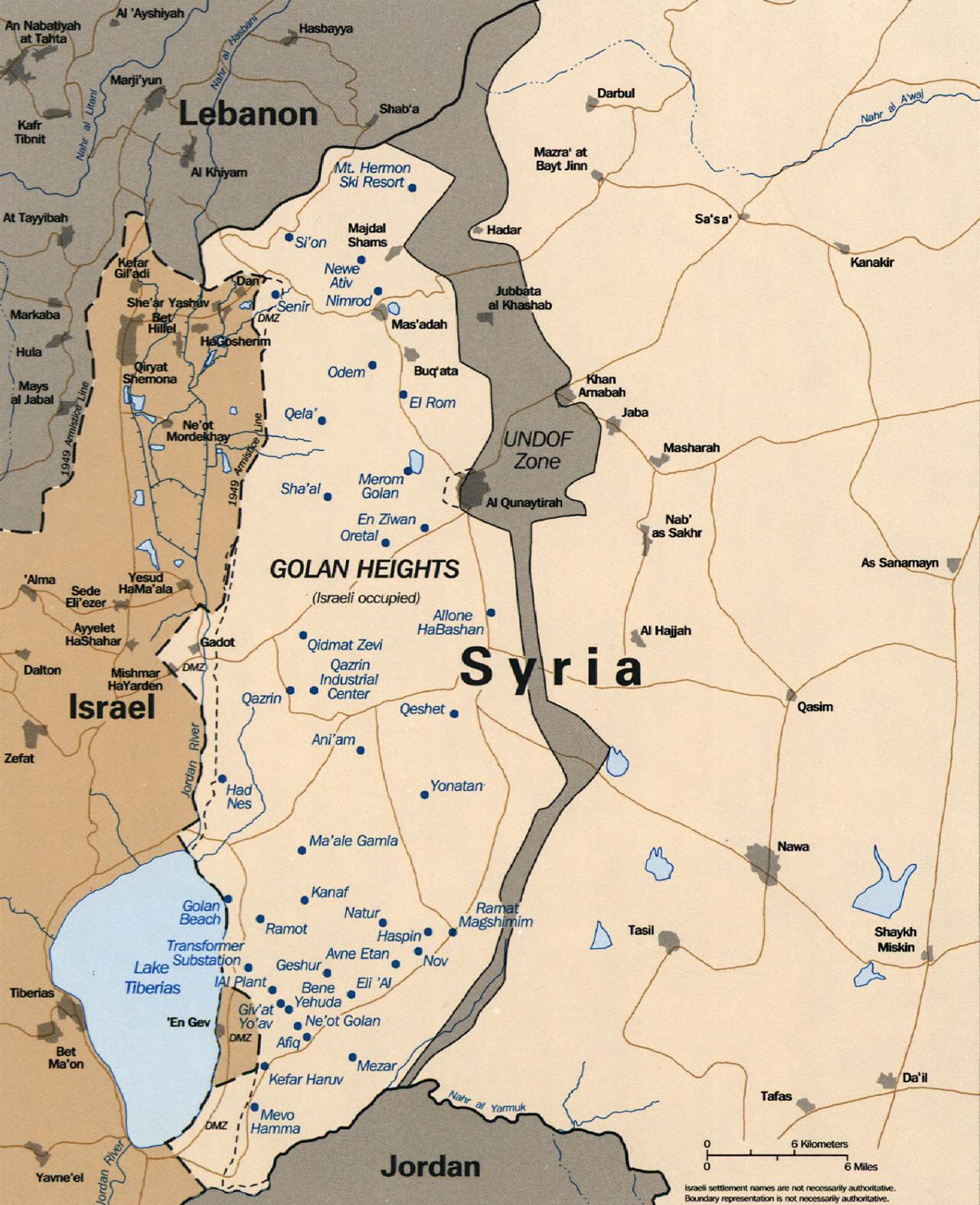
Golan Heights - 1994 (Library of Congress)
Immediately following this development, United Nations Security Council Resolution 497, adopted on 17 December 1981, declared invalid and null the Israeli decision to apply its laws, jurisdiction, and administration to occupied Syrian Golan; thus, the debate over the status of the Golan intensified beyond the ceasefire arrangement to center on the issue of unilateral alteration of territorial status.【11】
Within this framework, one of the key nodes in the withdrawal debate is the question of which boundary line should be returned to: one approach advocates a return to the pre-1967 borders, while the other takes the 1923 boundary as its primary reference. The fact that the difference between these two lines is concretized in a technical yet consequential detail—the inclusion or exclusion of three small areas granting access to the Jordan and Yarmouk rivers—demonstrates that the Golan’s status debate is deeply intertwined with resource access.
The Golan Heights constitute an elevated area with a volcanic plateau character, covered largely by basalt, extending northeast and east of the Sea of Galilee. Geographically, it lies between approximately 32°40′–33°15′N latitude and 35°35′–35°50′E longitude. It is bounded to the west by the Jordan River and the Sea of Galilee, to the north by Mount Hermon, to the east by the seasonal Wadi El-Ruqqād, and to the south by the Yarmouk River.【12】
In the northern section of the plateau, elevations reach approximately 1,200 meters; Mount Hermon, located in the Lebanon-Israel-Syria border region, rises to 2,809 meters, forming a prominent elevation threshold. In contrast, elevations along the Yarmouk River in the south drop to an average of 400 meters; the Sea of Galilee, located in the southwestern corner of the Golan, lies approximately 200 meters below sea level, with a more precise measurement of -212 meters.【13】 This vertical variation creates conditions for rapid elevation changes over short distances, resulting in significant local distinctions in climate and land use.

A View from the Golan Heights (Flickr)
Topographically, the western edge of the plateau features steep escarpments and cliffs descending toward the upper reaches of the Jordan Valley and the Sea of Galilee. As the volcanic plateau extends westward, it descends to 70 meters above sea level in the Hula Valley, then rises again to approximately 340 meters, forming a transitional morphological pattern. Its width ranges between 12 and 25 kilometers; this scale provides a defining framework for orographic (elevation-driven) precipitation processes and internal watershed catchment areas.
The climate of the Golan is linked to the Eastern Mediterranean pattern of wet winters and dry summers; however, due to elevation and slope orientation, significant variations occur within the region. Influenced by prevailing wind patterns, western slopes receive more rainfall than eastern slopes. Annual average rainfall is reported to approach 1,200 mm in the north and drop to approximately 450–500 mm in the southern sections, indicating a clear decline in moisture from north to south. The rainy season extends from October to early May, with peak precipitation occurring between December and February.
Winter conditions, especially in the northern section, manifest as brief snowfall events; in the Mount Hermon area, snow cover can persist for approximately six months. This is not merely a meteorological observation but also an environmental threshold, as snowmelt contributes to spring water availability.
Broader basin-scale temperature data for the Jordan Basin, which includes the Golan, provide a concrete climatic context: the annual average temperature across the basin is approximately 18°C, with January averages of 9°C (as low as 5°C in the coldest areas) and August averages of 26°C (rising to 30°C in the warmest areas). These values illustrate a climatic framework in which cooler conditions and snow/glacial processes become more significant at higher elevations, while evaporation pressure increases as elevation decreases.
The primary factor shaping the physical environment of the Golan is the extensive distribution of basalt and other volcanic rocks. These volcanic rocks are said to date from the Pliocene–Pleistocene epochs; this geological substrate is described as a “wavy rural topography” scattered with lava flows, basalt outcrops, and volcanic cones. The steep escarpments along the western edge of the plateau, combined with abrupt elevation loss toward the Jordan Valley–Sea of Galilee axis, generate distinct micro-environments in terms of surface runoff and erosion potential.
In the Mount Hermon area, a different lithological framework emerges: the mountain is largely composed of Jurassic limestone with high solubility in water. This feature, combined with high rainfall and snowmelt, creates favorable conditions for the development of karst landforms; subsurface water infiltration and spring recharge processes become more visible on this substrate.

Golan Heights - Aerial View (Flickr)
Land cover and vegetation are directly linked to this geological substrate. A fragmented vegetation cover is described between basalt outcrops and lava flows; in the zone below the snow line around Mount Hermon, vineyards are found alongside trees such as pine, oak, and poplar. This pattern demonstrates how the “elevation–rainfall–soil” triad shapes both agriculture and natural vegetation, with denser and more diverse plant production emerging in areas with greater water access.
Wind patterns are also noted as an influencing environmental factor: cool breezes blow from northwest to southeast along the plateau during both winter and summer, sometimes reaching storm intensity.
The environmental vulnerabilities of the Golan are assessed not only through annual rainfall averages but also through the spatial distribution of rainfall, short-term cloud system dynamics, and the prolongation of drought periods. Climate projections for the Eastern Mediterranean suggest that temperatures may rise by 2–3°C by 2050 and 3–5°C by 2100; accordingly, water availability is projected to decrease by 2–15% for every 2°C of warming.【14】
Such an aridification trend could intensify intra-seasonal variability and drought risk even in areas of relatively higher rainfall in the northwest.
A critical dimension of environmental risk lies in the fact that rainfall depends not only on atmospheric moisture levels but also on microphysical processes that convert moisture into rain or snow. Short-lived cloud systems, influenced by air pollution particles, may slow the transformation of cloud droplets into rain or snowfall; over the long term, this could weaken the orographic enhancement of rainfall on mountain ranges and elevation thresholds.
Within this framework, an annual “usable water loss” of approximately 110 million cubic meters is estimated to explain the decline in water available for consumption from the Sea of Galilee and the headwaters of the Jordan River, independent of local rainfall. Such a mechanism demonstrates that environmental security in the Golan and its surroundings depends not only on total rainfall but also on rainfall generation processes and human-induced pressures affecting them.
The hydrographic profile of the Golan Heights is understood in relation to the “upper basin” dynamics of the Jordan River Basin. The basin covers approximately 18,500 square kilometers; 40% lies within Jordan, 37% within Israel, 10% within Syria, 9% within the West Bank, and 4% within Lebanon.【15】
The Jordan River, a 250-kilometer-long river system, originates from three main tributaries—the Dan, Banias, and Hasbani—which converge and flow southward through the Hula Valley to the Sea of Galilee. After exiting the Sea of Galilee, the river, in its lower section, is fed by its most significant tributary, the Yarmouk River.

A Waterfall in Mount Hermon (Flickr)
The Yarmouk originates in Jordan, forms part of the Jordan-Syria border and later the Jordan-Israel border, and then joins the lower Jordan River. Further south, the Jordan River serves as a boundary between Israel and the West Bank, and between Jordan and Israel, before emptying into the Dead Sea.
In this context, the Golan, due to its topographic position opening toward the Sea of Galilee and the upper reaches of the Jordan system, is directly linked to areas where water flow is collected and channeled. Thus, the region has become an integral part of the broader debate on “basin-wide water security,” as much as it is central to geopolitical discussions.
The basin’s water regime exhibits extreme seasonality. Records indicate that February alone can account for approximately 40% of the river’s annual flow, while during periods of high demand—summer and autumn—flow drops to only 3–4% of the annual total. Consequently, capturing and storing winter floodwaters is among the most critical technical priorities of basin management; unstored water rapidly flows southward into the Dead Sea, further exacerbating the imbalance in intra-annual water distribution.

Sea of Galilee (NASA)
Drought periods significantly intensify this pattern. For example, during the 1987–1991 drought, basin flow declined by up to 40% on an annual basis. Such a reduction generates cascading pressures not only on drinking water and agricultural irrigation but also on lake levels, water quality, ecosystem stability, and transboundary allocation disputes.
In the Jordan River Basin, “water scarcity” is defined not as an abstract concept but through measurable indicators. Most basin countries fall well below the widely used absolute scarcity threshold of 500 cubic meters per capita annually. Renewable water availability per capita in 2006 was as follows:【16】
The distribution of water sources by type is also notable: surface waters account for 35%, groundwater for 56%, and treated wastewater and other non-conventional sources for 9%. This distribution indicates that aquifers and reuse practices, not just river and lake systems, are central to water security in the basin.
Regarding flow contributions, figures underscore the importance of the upper basin: Israel receives annual inflows of 138 million cubic meters from the Hasbani River in Lebanon, 125 million cubic meters from Syria, and 20 million cubic meters from the West Bank. The “natural” annual flow of the Yarmouk River from Syria into Jordan is estimated at 400 million cubic meters; however, due to drought and upstream developments in the 1980s, current actual flows are reported to be below this level.【17】 This gap forms the technical basis for the tension between “paper allocations” and “on-the-ground water.”
Water management in the basin largely proceeds through storage and conveyance infrastructure and water quality interventions. Agricultural water withdrawal is estimated at approximately 1.2 km³ annually; in Jordan, the East Ghor Canal was constructed beginning in 1958 to transfer Yarmouk waters to the Jordan Valley, later renamed the King Abdullah Canal. This canal, initially 70 kilometers long in 1961, was extended three times between 1969 and 1987 to reach a length of 110.5 kilometers.
Since the 1990s, the transformation of a significant portion of open canal systems into pressurized irrigation networks has emerged as a structural change aimed at improving water efficiency. In Israel, a national water transfer system was established in the 1950s, drawing water from the northern end of the Sea of Galilee and transporting it over long distances across the country.
Regarding water quality, the level and salinity of the Sea of Galilee are critical. After continuous declines in lake levels since 1996, the minimum “red line” was lowered from 213 meters below sea level to 215.5 meters below sea level in 2001. Low water levels generate a series of risks, including ecosystem instability, water quality degradation, shoreline retreat, and negative impacts on tourism and recreation.
To reduce salinity, specific saline inflows along the northwestern shore are directed into a “saline water canal,” which annually removes approximately 70,000 tons of salt and 20 million cubic meters of water from the lake. These engineering interventions are notable.
The same canal is also used to divert treated wastewater from surrounding settlements away from the lake and into the lower Jordan River; efforts to reduce nutrient loads include changes in agricultural and irrigation practices, reduction of fishpond areas, improvement of drainage networks, and upgrading of treatment facilities.
This picture demonstrates that the hydrographic environment surrounding the Golan Heights must be understood not merely in terms of “resource availability” but in conjunction with seasonality, drought, infrastructure and redirection, water quality interventions, and transboundary allocation tensions.
The strategic value of the Golan Heights stems primarily from its high plateau character. The sharp elevation changes over short distances along the western slopes facing the Sea of Galilee and the Jordan Valley make the region critical for observation lines and fire control. In such topography, defense planning is structured around area dominance and early warning rather than troop concentration along a line: an observation point on the elevation can monitor movement across a wide sector; consequently, low-elevation settlements, transportation routes, and water infrastructure become more visible and vulnerable.

A View from the Golan Heights - Elevations Exceeding 1,000 Meters Visible in the Background (Anadolu Ajansı)
In this context, the Golan is not merely a location where a border line passes but is viewed as a strategic buffer influencing the broader area surrounding the border. The persistence of strategic debates stems not from unchanging geographic features but from how this geography generates distinct “security risks” for each side: for one side, loss of elevation renders population centers and infrastructure more vulnerable; for the other, control of the elevation provides a critical advantage in deterrence and border security.
The Golan line, operating within a long-term ceasefire regime, manifests security debates not primarily through the language of “hot conflict” but through violations, restrictions, transit, and monitoring. Within this framework, movement on the ground is limited to specific crossing points and procedures; where crossings are permitted, they are shaped by coordination and security checks between the parties.
Reported examples on the ground indicate that barriers along the ceasefire line extend approximately 12.5 kilometers in length, consisting of ditches approximately 5 meters wide and 3 meters deep, and berms approximately 3 meters high. In some locations, these barriers extend 5–20 meters into the area of separation. Such details reveal that security measures generate a control logic extending beyond the line itself to encompass the surrounding terrain.
Another critical element in the security arrangement is airspace and surveillance technology. Alongside ground-drawn lines, aircraft, unmanned systems, and electronic surveillance have become decisive in border security, leading to a concentration of violation debates around “airspace and reconnaissance activities.” Thus, security in the Golan has evolved beyond the classical “border outpost” model into a complex monitoring domain integrating land, air, and communication dimensions.
The deepening of the civil war in Syria after 2011 directly affected the security environment around the Golan, transforming risks along the border from uniform to multi-layered. The key change during this period was the increased presence of non-state armed actors on the other side of the border, the emergence of local security vacuums, and the occasional overlap of different power centers within the same geography. In such an environment, the ceasefire line became not merely a boundary between two states but a security threshold indirectly influenced by local and regional actors.
These conditions have also complicated observation and monitoring activities. Security-related restrictions on patrols and movement, stricter transit procedures, and practices such as road closures and barrier installations have made daily management of the border more fragile. Thus, the post-2011 period represents a phase in which stability requires more procedural coordination and risk management than the classical “inter-state frontline” model.
In the 2020s, security debates are often observed not as large-scale war scenarios but as patterns of low-intensity tension and rule violations. These patterns are generally grouped under three headings:
1. Movement and access restrictions: Closure of patrol routes, security-based restrictions on access to certain areas, and periodic intensification of transit procedures.
2. Events near the ceasefire line: Types of incidents such as firing near the line, proximity or contact with the boundary, and allegations of crossing the border.
3. Physical infrastructure changes: Permanent modifications to the landscape such as barrier systems, ditches/berms, new road arrangements, and marking elements.
Another factor enhancing the strategic value of the Golan in this period is the increasing linkage between security and resource management. Infrastructure elements such as water systems, energy and communication lines, and transportation corridors carry a dual character: they ensure economic continuity while also being highly sensitive from a security perspective. Thus, the Golan maintains its status as both a border region where the ceasefire regime is sustained and a strategic space where environmental and infrastructural vulnerabilities are integrated into the security agenda.
The ceasefire arrangement on the Golan line became institutionalized with the operationalization of the disengagement mechanism established in 1974. Within this regime, the United Nations’ role is shaped around observation, reporting, and liaison activities aimed at preventing the resurgence of military contact between the parties.
The ground arrangement operates not merely along a “line” but through the area of separation and the limitation zones on both sides. This framework enables the preservation of the ceasefire not only through isolated incidents but also through the management of movement, monitoring procedures, and standardization of violation types.
An important component of the institutional structure is the Observer Group Golan, a military observer unit under the United Nations Disengagement Observer Force. These observers operate under the operational control of the UNDOF commander and conduct continuous situational monitoring through ten fixed observation points within the UNDOF area.【18】
UNDOF’s operational functioning consists of two primary activities: static observation (continuous monitoring from fixed points) and mobile patrols (systematic scanning of the area). Patrol routes are planned to cover the entire area of separation; coverage in the limitation zones is lower. Records indicate that patrols cover the full area of separation and approximately 70% of the limitation zones; in particular, security vulnerabilities in the southern section of the Bravo side have made it difficult to open new patrol routes.

A View from the Golan Heights - One of the Areas Actively Monitored by UNDOF (Anadolu Ajansı)
The intensity of operations is important for demonstrating the “on-the-ground routine” of the ceasefire regime. For example, monthly operational activity counts during a specific three-month period were recorded as 1,097 in August, 1,122 in September, and 1,138 in October. Such figures demonstrate that the preservation of the ceasefire depends not only on high-level political decisions but also on continuous, small-scale, daily operations on the ground.
In terms of monitoring, regular inspections of the parties’ military positions are emphasized. Through Observer Group Golan, with the facilitation of both parties, military position inspections are conducted every two weeks; efforts have been sustained to expand the scope of inspections on both the Alpha and Bravo sides. These inspections serve not only to detect violations but also to maintain a shared understanding on the ground of what is permitted and what is prohibited.
One of the most sensitive operational areas of the ceasefire regime is freedom of movement and transit procedures. The Quneitra crossing serves as both a symbolic and functional node in this regard. Records indicate that since early March 2020, prior notification has been required for crossings through the Alpha gate, negatively affecting the operational and administrative activities of UNDOF and Observer Group Golan.【19】
Following developments after 7 October 2023, these movements were further restricted; however, during a specific reporting period, two planned weekly crossings at the Alpha gate were maintained, along with 21 operational, one emergency, and two humanitarian crossings facilitated.
On the Bravo side, procedures have stabilized. With the transition to established transit practices, personnel movement and logistical flows are now operated within “standard procedures.” Meanwhile, restrictions on access to observation points within the area of separation via technical fence gates on the Alpha side have slowed not only patrol activities but also infrastructure and repositioning processes.
Technical fence gates are access points used by UNDOF to transport equipment and personnel to certain locations within the area of separation, particularly observation points. When their use was restricted, access to UNDOF’s Observation Point 52 became difficult, slowing repair and reconstruction work at the site.
UNDOF’s reporting language classifies incidents not according to “who is right” but according to violations of the ceasefire regime and actions that disrupt the ground order. In this framework, violations include pedestrian or vehicle crossings of the ceasefire line, aircraft movement over the area of separation, firing, explosions, and heavy weapon sounds, all of which are recorded as incident types.
Some incidents directly affect the physical functioning of the boundary: along the ceasefire line, a system of counter-movement barriers extends across four locations with a total length of approximately 12.5 kilometers, consisting of ditches approximately 5 meters wide and 3 meters deep, berms approximately 3 meters high, and large rock blocks on the eastern side.
These barriers are recorded as extending 5–20 meters into the area of separation, and at some points, five separate road closures have been created using rock and earth. Such engineering elements transform the ceasefire line from a mere “line” into a measurable physical arrangement on the ground.
Another “concrete” dimension of the ceasefire regime is the marking system. Lines defining the area of separation are made visible on the ground through specific markers. In this context, maintenance and renewal of barrel markers designating the ceasefire line and the Bravo line have been carried out; during one period, 129 markers along the ceasefire line and 153 along the Bravo line were restored and repainted. This demonstrates that the ceasefire regime is not merely a political agreement but a ground infrastructure requiring continuous maintenance.
One of the foundational pillars of the international law debate regarding the Golan Heights is the principle set adopted after 1967.【20】 The first key principle is the inadmissibility of acquiring territory by force. This approach rests on the assumption that a de facto situation resulting from conflict cannot by itself produce a permanent change in sovereignty.
The second principle concerns withdrawal from occupied territories. When combined with the question of “which line to return to,” this debate becomes concrete and brings the 1923, 1949, and 1967 reference lines simultaneously into focus in the Golan case.
The third principle emphasizes the right of all states in the region to live in peace within secure and recognized borders, based on respect for sovereignty, territorial integrity, and political independence. This shows that the withdrawal debate is not merely a “military retreat” but a matter of broader regional security architecture.
After the 1973 Arab-Israeli War, the international framework became linked not only to “general principles” but also to operational mechanisms on the ground. This phase saw a two-way process: first, the cessation of hostilities and establishment of a ceasefire; second, the creation of a negotiation framework aimed at a lasting solution based on the principle set established in 1967.
The 1974 disengagement arrangement is the on-the-ground implementation of this framework. The area of separation and limitation zones demonstrate that the ceasefire has moved beyond being an “abstract line” to becoming a spatial regime governed by specific rules. Within this regime, classification of violations, movement restrictions, transit procedures, and monitoring mechanisms generate an institutional language aimed at sustaining stability on the ground, independent of political friction.
The Golan Heights Law adopted in 1981 was formulated as a measure to apply Israeli law, jurisdiction, and administration to the region. Although the term “annexation” was not used in the text, such a measure was widely interpreted internationally as a unilateral attempt to change the status quo. At this point, the legal debate shifted to focus on the question of whether unilateral changes to sovereignty rules in an occupied territory are permissible, regardless of the existence of occupation.
The response to this development is framed around the principles of “invalidity” and “non-recognition.” “Invalidity” asserts that unilateral arrangements have no legal consequences under international law; “non-recognition” imposes an obligation on other states not to recognize such a status change and to refrain from actions consistent with it. Thus, the Golan issue has moved beyond the confines of the on-the-ground ceasefire regime to become a point of intersection between questions of how sovereignty is acquired and what actions are legitimate in occupied territories.
Occupation law is the normative framework activated when a territory is under the actual authority of a foreign military. The decisive factor in this framework is not the claim of sovereignty but the existence of de facto control. Therefore, the extension of domestic law or administrative measures in an occupied territory does not imply an automatic change in status; on the contrary, unilateral status changes under occupation intensify legal debates.
Discussions on limiting the negative effects of occupation focus on three areas. First, regulations concerning the protection of civilians and the continuation of daily life: efforts aim to maintain public order and civil life while restricting arbitrary interference and safeguarding fundamental rights.
Second, a cautious approach is developed toward practices that may create an impression of permanent sovereignty, particularly regarding property and resource use. Third, long-term occupation leads to administrative, demographic, and economic transformations that shift the status debate from a purely legal issue to one of social and political continuity.
Therefore, the Golan Heights are regarded as an example where “de jure” claims of sovereignty are separated from “de facto” control, and where this separation directly affects recognition, negotiation, and security architecture.
The settlement structure in the Golan Heights has been shaped on a “border geography” intertwined with the security regime. The plateau’s high elevation concentrates most settlements on the plateau surface and near transportation corridors; the steep slopes descending westward toward the Jordan Valley and the Sea of Galilee affect both settlement distribution and the fragmentation of agricultural production areas.
Before the 1981 Golan Heights Law established its administrative-legal framework, the region was home to 28 rural communities and the planned urban settlement of Katzrin; this reference indicates that settlement typology in the Golan developed along a dual model of “rural community + administrative/urban center.”
The functioning of settlements on the ground is understood not only in terms of where people live but also in terms of how transit points, control areas, and restriction regimes shape daily movement. Thus, settlements in the Golan are evaluated within a spatial framework defined by proximity to the border and freedom of movement, rather than by classical “urban growth” logic.
Numerically, approximately 50,000 people live in the region, of whom about 27,000 are Arab and 23,000 are Jewish. Between 1994 and 2014, the Jewish resident population increased by approximately 7,000, while the Arab population increased by approximately 11,000.【21】 This comparison reveals two outcomes: (i) population growth is not unique to a single community; (ii) demographic change must be interpreted alongside security and governance debates, as well as everyday life, economic opportunities, and settlement continuity.

Israeli Settlements in the Golan - 1992 (Library of Congress)
The demographic profile of the Golan is not merely a matter of numbers; it is also situated at the intersection of identity, permanence, and status debates. The distinction between “settlement” and “indigenous community” attributed to the region produces different effects in areas such as access to public services, land use, and freedom of movement; thus, in the context of the Golan, demography often becomes a carrier of political-legal debate.
The economy of the Golan is largely based on a production system determined by the triad of land cover, climate, and water. The volcanic basalt substrate and plateau topography provide an environmental foundation enabling both grazing and agricultural production; however, the increase in rainfall from north to south spatially differentiates production patterns.
The vegetation cover of the region has changed under historical pressure from land use (agriculture, grazing, forestry); for example, the historical decline in cypress presence and its replacement by oak communities illustrate the long-term impacts of land use.
Agriculture and livestock are closely linked to access to water resources and irrigation capacity. Viewed at the basin scale, the seasonality of water (high flow in winter, low flow in summer) directly affects agricultural planning; thus, the sustainability of production depends not only on local rainfall but also on storage/distribution infrastructure and water management choices.
In the Golan, particularly in the northern zone, the relatively cooler climate and higher rainfall create a favorable environmental background for certain agricultural products such as viticulture and horticulture; conversely, production in drier zones becomes more vulnerable under water constraints.
The social fabric of the Golan is shaped within the duality of “normalization–exceptionality” imposed by border geography. On one hand, settlements and production areas sustain daily life; on the other, the ceasefire regime and security practices restrict mobility and spatial use. Thus, daily life must be understood not only through economic practices such as farming and grazing but also through transit procedures, control zones, and periodic security fluctuations.
Cultural and religious meanings attributed to the region also influence social perception. Interpretations of the Golan as “sacred” in Jewish tradition generate a symbolic layer in settlement debates. Meanwhile, narratives regarding the presence and settlements of various communities demonstrate that the region is contested not only through military and legal lenses but also through identity and belonging.
The diplomatic debate surrounding the Golan Heights is structured around a tripartite parameter set: the reference line defining the border, the structure of the security arrangement, and the management of water resources and the basin. The border issue constitutes a debate field where the 1923 international boundary, the 1949 armistice line, and the pre-1967 de facto lines are simultaneously treated as references.
The security issue forms the most contentious layer of negotiations due to differing interpretations of the advantages of early warning and area dominance generated by the high plateau topography. The water issue, though often appearing “technical,” enters the negotiation arena alongside border and security concerns due to the necessity of managing the Jordan Basin under seasonal variability and drought pressures.
While each of these three issues appears solvable in isolation, in practice they form a mutually reinforcing structure: the border arrangement affects water access, water management affects economic sustainability, and economic sustainability sustains security risks and social stability.
In the diplomatic dossier on the Golan, the distinction between de facto control and legal status is the fundamental determinant. The step taken in 1981 with the Golan Heights Law to apply Israeli law, jurisdiction, and administration to the region did not remain an administrative adjustment; it transformed the status of the Golan from a “de facto situation” into a “status change” debate.
From this point onward, diplomatic language hardened along two opposing lines: on one side, the approach asserting that status cannot be unilaterally altered through invalidity and non-recognition; on the other, the claim of permanence arising from institutionalization of de facto governance.
This duality generates continuous tension between the “on-the-ground reality” and the “legal outcome.” While ceasefire preservation and conflict de-escalation remain possible, the unresolved status debate leaves the dossier as a “frozen” dispute, causing most diplomatic initiatives to rely on limited stability mechanisms rather than comprehensive agreements.
With the outbreak of civil war in Syria in 2011, the security environment around the Golan shifted away from the classical frontline of two regular armies toward a more variable and multi-layered structure. During this period, risks along the border were no longer confined to “ground contact”; restrictions on movement, fluctuations in transit procedures, the presence of local armed elements, and aerial incidents gained equal importance. Under these conditions, the implementation of the ceasefire regime became an area requiring greater coordination and continuous procedural management to preserve stability on the ground.
In the 2020s, the perception of security has become more sensitive to short-term threats. This has led, not to facilitating comprehensive status negotiations, but to prioritizing practical measures that prevent escalation on the ground—such as patrol-observation arrangements, transit regimes, classification of violations, and maintenance of communication channels. During such periods, diplomatic discourse has focused less on final solutions and more on the sustainability of measures that reduce the risk of miscalculation and limit the spread of tension.
Within this general framework, the political rupture in December 2024 and its consequences for the border are notable. Records indicate that following the overthrow of Bashar al-Assad’s regime by HTS, Israel claimed a “new front” had emerged along the Syrian border, approved the expansion of settlements in the Golan, and announced a stimulus plan allocating 40 million shekels to double the population.【22】
On the Golan Heights (TRT - Doğrusu Ne?)
In the same context, it is noted that over 30 Israeli settlements exist in the Golan, housing approximately 20,000 people, who live alongside approximately 20,000 Syrians, mostly Druze, in the same geography.【23】 These developments constitute a concrete example of how the “settlement and demography” dimension of the Golan has re-emerged alongside the security discourse.
During the same period, the buffer zone issue also resurfaced. In the days following Assad’s overthrow, Israeli forces entered the buffer zone separating the Golan from Syria, assessing that the disengagement arrangements had “collapsed”; this triggered a dispute over violation of the 1974 disengagement agreement. Simultaneously, numerous airstrikes were conducted against targets within Syria; some accounts report over 450 attacks since 8 December.【24】 This picture indicates a strengthening of the link between “on-the-ground arrangements” and “political-military maneuvers.”
According to records dated 4 December 2025, the Israeli military conducted 12 artillery strikes from the occupied Golan Heights targeting rural areas of Syria’s Dera and Quneitra, specifically aiming at the village of Kuweyya west of Dera and the Tel Ahmer area in Quneitra’s rural zone.【25】 Such incidents demonstrate that the variety of risks developed since 2011 has continued into the mid-2020s through “cross-border fire support / retaliation” actions; thus, the fragility of the ceasefire regime is closely linked not only to institutional procedures but also to regional political fluctuations.
In the Golan dossier, water is not merely a historical arena of competition; due to increasing drought, rising temperatures, and water quality pressures in the 2020s, it has become a “future-oriented” diplomatic parameter. The extremely low levels of renewable water per capita across the basin elevate water from a mere infrastructure issue to a “strategic scarcity” issue.
In this context, water plays two roles in negotiations: on one hand, it intensifies border and security debates (access and control of resources); on the other, it creates potential for technical cooperation due to shared vulnerability (flood management, pollution control, allocation during droughts, early warning). This dual character means that while rising environmental risks may narrow diplomatic space, they can also generate limited but functional cooperation frameworks.
Anadolu Ajansı. “Golan Tepeleri’ndeki Suriyeliler, İsrail İşgalinin Sona Ermesini ve Barışın Sağlanmasını İstiyor.” January 7, 2025. Accessed December 13, 2025.https://www.aa.com.tr/tr/pg/foto-galeri/golan-tepelerindeki-suriyeliler-israil-isgalinin-sona-ermesini-ve-barisin-saglanmasini-istiyor/146
BBC Türkçe. “İsrail, Golan Tepeleri'ndeki yerleşimleri genişletme kararı aldı.” December 12, 2024. Accessed December 13, 2025.https://www.bbc.com/turkce/articles/c878113j77go
Başköylü, Şeyma Yıldız. “Golan Tepeleri’nin İsrail Açısından Önemi.” *İNSAMER Rapor*, no. 161 (November 2022). Accessed December 13, 2025.https://www.insamer.com/tr/uploads/pdf/golan-tepelerinin-israil-acisindan-onemi-seyma-yildiz-baskoylu.pdf
Boyraz, Turgut Alp. “İşgal Altındaki Golan Tepeleri İsrail İçin Neden Önemli?” Anadolu Ajansı, March 22, 2019. Accessed December 13, 2025.https://www.aa.com.tr/tr/dunya/isgal-altindaki-golan-tepeleri-israil-icin-neden-onemli/1425457
Dave and James. “Golan Heights.” Flickr. 2016. Accessed December 13, 2025.https://www.flickr.com/photos/flufflebuns/26202986282/in/album-72157666855389485.
Dave and James. “Golan Heights.” Flickr. 2016. Accessed December 13, 2025.https://www.flickr.com/photos/flufflebuns/26251624966/in/album-72157666855389485.
Dave and James. “Golan Heights.” Flickr. 2016. Accessed December 13, 2025.https://www.flickr.com/photos/flufflebuns/26277585075/in/album-72157666855389485
Dave and James. “Golan Heights.” Flickr. Accessed December 13, 2025.https://www.flickr.com/photos/flufflebuns/26277511275/in/album-72157666855389485.
Dağ, Burak. “İsrail Ordusu, İşgal Altında Tuttuğu Golan Tepeleri’ndeki Şeyh Dağı’nın Suriye Tarafını İşgal Etti.” *Anadolu Ajansı*, December 8, 2024. Accessed December 13, 2025.https://www.aa.com.tr/tr/dunya/israil-ordusu-isgal-altinda-tuttugu-golan-tepelerindeki-seyh-daginin-suriye-tarafini-isgal-etti/3418389
Duyar, Metin. “Yıkılan Bir Rejim Pekişen Bir Strateji: İsrail'in Golan Politikası ve Suya Dayalı Hegemonyası.” *TASAM*. April 9, 2025. Accessed December 13, 2025.https://tasam.org/tr-tr/Icerik/73832/yikilan_bir_rejim_pekisen_bir_strateji_israilin_golan_politikasi_ve_suya_dayali_hegemonyasi
Fanack Water. "Water Resources in Israel." August 15, 2025. Accessed December 13, 2025.https://water.fanack.com/israel/water-resources-in-israel/
Fayez, Abdulsalam, and Ali Semerci. “Suriye: İşgal altındaki Golan Suriye toprağıdır ve onun tamamını İsrail’den geri alma hakkına sahibiz.” *Anadolu Ajansı*. December 3, 2025. Accessed December 13, 2025.https://www.aa.com.tr/tr/dunya/suriye-isgal-altindaki-golan-suriye-topragidir-ve-onun-tamamini-israilden-geri-alma-hakkina-sahibiz/3760455
Givati, Amir, and Daniel Rosenfeld. “Possible Impacts of Anthropogenic Aerosols on Water Resources of the Jordan River and the Sea of Galilee.” *Water Resources Research* 43, no. 10 (October 17, 2007): W10419. Accessed December 13, 2025.https://agupubs.onlinelibrary.wiley.com/doi/full/10.1029/2006WR005771
Israel Central Bureau of Statistics. “Israel in Figures 2024.” Accessed December 13, 2025.https://www.cbs.gov.il/he/publications/DocLib/isr_in_n/isr_in_n24e.pdf.
Karabacak, Muhammed. “İsrail Ordusu, Suriye’nin Dera ve Kuneytra Kırsalına Topçu Saldırısı Düzenledi.” *Anadolu Ajansı*, December 4, 2025. Accessed December 13, 2025.https://www.aa.com.tr/tr/dunya/israil-ordusu-suriyenin-dera-ve-kuneytra-kirsalina-topcu-saldirisi-duzenledi/3762478
Karaoğlu, Ali Osman. “Israel and Syria Dispute: The Legal Consequences of the Expansion of the Occupation of the Golan Heights.” Accessed December 13, 2025.https://lawandjustice.taa.gov.tr/dergiler/makale/law-30-6.
Kaufman, Asher. *Contested Frontiers in the Syria-Lebanon-Israel Region: Cartography, Sovereignty, and Conflict*. Washington, DC: Woodrow Wilson Center Press / Johns Hopkins University Press, 2014. Accessed December 13, 2025.https://www.researchgate.net/publication/368374196_Contested_Frontiers_in_the_Syria-Lebanon-Israel_Region
Knesset. "Golan Heights Law, 5742–1981." December 14, 1981. Accessed December 13, 2025.https://main.knesset.gov.il/EN/about/history/Documents/kns10_golan_eng.pdf
Korman, Sharon. *The Right of Conquest: The Acquisition of Territory by Force in International Law and Practice*. Oxford: Clarendon Press, 1996. Accessed December 13, 2025.https://www.researchgate.net/publication/375301100_The_Right_of_Conquest_The_Acquisition_of_Territory_by_Force_in_International_Law_and_Practice
Library of Congress Prints and Photographs Division. “Ain Geb. Jewish Settlement on East Side of S. Gal. [i.e., Sea of Galilee].” *Library of Congress.* Accessed December 13, 2025.https://www.loc.gov/pictures/resource/matpc.03683/.
Ma’oz, Moshe. *Syria and Israel: From War to Peacemaking*. Oxford: Oxford University Press, 1995. Accessed December 13, 2025.https://www.researchgate.net/publication/375303028_Syria_and_Israel_From_War_to_Peacemaking
Ministry of Foreign Affairs of the Republic of Türkiye. “No: 254, Regarding the Decision to Expand Israel’s Illegal Settlements in the OccupiedGolan Tepeleri.” December 16, 2024. Accessed December 13, 2025.https://www.mfa.gov.tr/no_-254_-israil-in-isgal-altindaki-golan-tepeleri-ndeki-yasadisi-yerlesimleri-genisletme-karari-hk.tr.mfa
NASA Science. “Sea of Galilee, Israel.” Photojournal. Accessed December 13, 2025.https://science.nasa.gov/photojournal/sea-of-galilee-israel/#:~:text=The%20Sea%20of%20Galilee%20(or,founded%20towns%20on%20the%20lake.
TRT Doğrusu Ne?. "Golan Tepeleri İsrail'in meşru topraklarıdır iddiası." YouTube. Accessed December 13, 2025.https://www.youtube.com/watch?v=GtExjmP7UCg.
Tomar, Cengiz. “El-Cûlân Golan olunca: Bir işgalin anatomisi.” *Anadolu Ajansı*, May 31, 2018. Accessed December 13, 2025.https://www.aa.com.tr/tr/analiz-haber/el-c%C3%BBl%C3%A2n-golan-olunca-bir-isgalin-anatomisi/1161569
UN Geospatial Information Section. “Syrian Arab Republic: UNDOF Deployment Map, June 2024.” ReliefWeb. Accessed December 13, 2025.https://reliefweb.int/map/syrian-arab-republic/syrian-arab-republic-undof-deployment-map-june-2024.
United Nations Convention to Combat Desertification (UNCCD) and International Drought Resilience Alliance (IDRA). *Drought Hotspots Around the World 2023-2025*. Prepared by the United States National Drought Mitigation Center. July 2025. Accessed December 13, 2025.https://www.unccd.int/sites/default/files/2025-07/Drought%20Hotspots%202023-2025_ENG.pdf
United Nations Disengagement Observer Force (UNDOF). "Force Commander Commences Her Tour of Duty." Golan Journal, no. 162 (June 2025). Accessed December 13, 2025.https://undof.unmissions.org/sites/default/files/golan_journal_jun_2025_-_issue_number_162.pdf
United Nations Food and Agriculture Organization. AQUASTAT Transboundary River Basins – Jordan River Basin. Rome: FAO, 2009. Accessed December 13, 2025.https://www.fao.org/aquastat/en/countries-and-basins/transboundary-river-basins/jordan/
United Nations General Assembly. “Israeli Settlements in the Occupied Palestinian Territory, Including East Jerusalem, and the Occupied Syrian Golan: Report of the Secretary-General.” A/80/399. September 25, 2025. Accessed December 13, 2025.https://www.un.org/unispal/document/report-of-the-secretary-general-25sep25/
United Nations Geospatial Information Section. “Syrian Arab Republic: UNDOF Deployment Map, June 2024.” Accessed December 13, 2025.https://reliefweb.int/map/syrian-arab-republic/syrian-arab-republic-undof-deployment-map-june-2024
United Nations Photo. “Ruins of Quneitra, Syria.” May 1, 1983. Accessed December 13, 2025.https://media.un.org/photo/en/asset/oun7/oun7698677
United Nations Photo. “United Nations Disengagement Observer Force in the Middle East.” June 16, 1974. Accessed December 13, 2025.https://media.un.org/photo/en/asset/oun7/oun7666547
United Nations Security Council. "Resolution 497 (1981)." December 17, 1981. Accessed December 13, 2025.https://docs.un.org/en/s/res/497(1981
United Nations Security Council. “Resolution 242 (1967).” November 22, 1967. Accessed December 13, 2025.https://digitallibrary.un.org/record/90717?v=pdf
United Nations Security Council. “Resolution 350 (1974).” May 31, 1974. Accessed December 13, 2025.https://digitallibrary.un.org/record/93704?v=pdf
United Nations. “Israeli-Syrian General Armistice Agreement (20 July 1949).” UN Peacemaker. Accessed December 13, 2025.https://peacemaker.un.org/sites/default/files/document/files/2024/05/il20sy490720israeli-syrian20general20armistice20agreement.pdf
United Nations. “Separation of Forces between Israel and Syria (31 May 1974).” UN Peacemaker. Accessed December 13, 2025.https://peacemaker.un.org/sites/default/files/document/files/2024/05/il20sy740531separation20of20forces20between20israel20and20syria.pdf.
United Nations. “The Occupied Syrian Golan: Report of the Secretary-General.” 2025. Accessed December 13, 2025.https://digitallibrary.un.org/record/4091947
United Nations. “United Nations Disengagement Observer Force: Report of the Secretary-General.” S/2024/875. December 2, 2024. Accessed December 13, 2025.https://docs.un.org/en/s/2024/875
United States Central Intelligence Agency. “Golan Heights and vicinity : October 1994.” Washington, D.C.: Central Intelligence Agency, 1994. Library of Congress. Accessed December 13, 2025.https://www.loc.gov/resource/g7462g.ct001958/?r=-0.775,0.282,2.549,0.976,0
United States Central Intelligence Agency. “Israeli settlements in the Golan Heights, February 1992.” Washington, D.C.: Central Intelligence Agency, 1974. Library of Congress. Accessed December 13, 2025.https://www.loc.gov/resource/g7462g.ct000487/?st=single
United States Central Intelligence Agency. “Israeli settlements in the Golan Heights, February 1992.” Washington, D.C.: Central Intelligence Agency, 1992. Library of Congress. Accessed December 13, 2025.https://www.loc.gov/item/92682948/
Yıldırım, Selim. “İsrail ve Suriye'nin Golan Tepeleri Üzerine Geliştirdikleri Söylemin Eleştirel Jeopolitik Analizi.” Master's thesis, TOBB Ekonomi ve Teknoloji Üniversitesi, Sosyal Bilimler Enstitüsü, 2020. Accessed December 13, 2025.https://tez.yok.gov.tr/UlusalTezMerkezi/TezGoster?key=fl0Kw4p1rmMDotyKRdYv1PPqooiXvPkLj_f0ku_C0HYRUkB5bE8GKvKbaluUHYA6
Çalık Topuz, Zuhal. “İsrail-Suriye Anlaşmazlığında Golan Tepeleri Sorunu.” *Bölgesel Araştırmalar Dergisi* 9, no. 1 (Mayıs 2025): 1–17. Accessed December 13, 2025.https://dergipark.org.tr/en/pub/bader/issue/92062/1538626
Çetintaş, Volkan. “Potansiyeli ve Jeopolitik Önemi Açısından Golan Tepeleri.” Master's thesis,Gaziantep Üniversitesi, Institute of Social Sciences, 2022. Accessed December 13, 2025.https://tez.yok.gov.tr/UlusalTezMerkezi/TezGoster?key=CG8WvdvvxJP04Unr7Yecf_r-iizND8UZnKIC7UHPMNCziJuVdm62Zb7WlHKVmKbv
Çınar, Murat. “Coğrafi ve Jeopolitik Açıdan Golan Tepeleri.” *Fırat Üniversitesi Sosyal Bilimler Dergisi* 32, no. 1 (January 2022): 19–36. Accessed December 13, 2025.https://dergipark.org.tr/tr/pub/firatsbed/issue/68126/974706
[1]
Volkan Çetintaş, “Potansiyeli ve Jeopolitik Önemi Açısından Golan Tepeleri” (Yüksek Lisans Tezi, Gaziantep Üniversitesi, Sosyal Bilimler Enstitüsü, 2022), s. 6.
[2]
Birleşmiş Milletler Güvenlik Konseyi. “Resolution 497 (1981).” 17 Aralık 1981, Erişim 13 Aralık 2025. https://docs.un.org/en/s/res/497(1981.
[3]
Amir Givati ve Daniel Rosenfeld, “Possible Impacts of Anthropogenic Aerosols on Water Resources of the Jordan River and the Sea of Galilee,” Water Resources Research 43, sy. 10 (17 Ekim 2007): W10419, s. 2. FAO bu oranı 1/3 olarak verir. Ayrıca bknz. FAO (Food and Agriculture Organization of the United Nations). AQUASTAT Transboundary River Basins – Jordan River Basin. Rome: FAO, 2009. Erişim tarihi: 13 Aralık 2025. https://www.fao.org/aquastat/en/countries-and-basins/transboundary-river-basins/jordan/, s. 1.
[4]
Volkan Çetintaş. (a.g.e), s. 51.
[5]
Cengiz Tomar. “El-Cûlân Golan olunca: Bir işgalin anatomisi.” Anadolu Ajansı. 31 Mayıs 2018, Erişim 13 Aralık 2025. https://www.aa.com.tr/tr/analiz-haber/el-c%C3%BBl%C3%A2n-golan-olunca-bir-isgalin-anatomisi/1161569.
[6]
United Nations Disengagement Observer Force (UNDOF), “Force Commander Commences Her Tour of Duty,” Golan Journal, no. 162 (Haziran 2025), s. 15.
[7]
United Nations Disengagement Observer Force (UNDOF), “Force Commander Commences Her Tour of Duty,” Golan Journal, no. 162 (Haziran 2025), s. 11.
[8]
United Nations Disengagement Observer Force (UNDOF), “Force Commander Commences Her Tour of Duty,” Golan Journal, no. 162 (Haziran 2025), s. 9.
[9]
Birleşmiş Milletler Güvenlik Konseyi. “Resolution 242 (1967).” 22 Kasım 1967, Erişim 13 Aralık 2025. https://digitallibrary.un.org/record/90717?v=pdf.
[10]
Volkan Çetintaş. (a.g.e), s. 21, 60, 62, 67.
[11]
Birleşmiş Milletler Güvenlik Konseyi. “Resolution 497 (1981).” 17 Aralık 1981, Erişim 13 Aralık 2025. https://docs.un.org/en/s/res/497(1981.
[12]
UN Geospatial Information Section. “Syrian Arab Republic: UNDOF Deployment Map, June 2024.” Erişim 13 Aralık 2025, https://reliefweb.int/map/syrian-arab-republic/syrian-arab-republic-undof-deployment-map-june-2024.
[13]
Volkan Çetintaş. (a.g.e), s. 6-10.
[14]
United Nations Convention to Combat Desertification (UNCCD) ve International Drought Resilience Alliance (IDRA), Drought Hotspots Around the World 2023-2025, prepared by the United States National Drought Mitigation Center (Temmuz 2025), s. 18-19.
[15]
United Nations Food and Agriculture Organization. AQUASTAT Transboundary River Basins – Jordan River Basin (Rome: FAO, 2009), s. 1.
[16]
United Nations Food and Agriculture Organization. AQUASTAT Transboundary River Basins – Jordan River Basin (Rome: FAO, 2009), s. 3.
[17]
United Nations Food and Agriculture Organization. AQUASTAT Transboundary River Basins – Jordan River Basin (Rome: FAO, 2009), s. 3-4.
[18]
United Nations Disengagement Observer Force (UNDOF). “Force Commander Commences Her Tour of Duty.” Golan Journal, no. 162 (Haziran 2025), s. 13.
[19]
Birleşmiş Milletler Güvenlik Konseyi. “United Nations Disengagement Observer Force: Report of the Secretary-General.” S/2024/875. 2 Aralık 2024. Erişim tarihi: 13 Aralık 2025, s. 5.
[20]
Birleşmiş Milletler Güvenlik Konseyi. “Resolution 242 (1967).” 22 Kasım 1967, Erişim 13 Aralık 2025. https://digitallibrary.un.org/record/90717?v=pdf.
[21]
Murat Çınar. “Coğrafi ve Jeopolitik Açıdan Golan Tepeleri.” Fırat Üniversitesi Sosyal Bilimler Dergisi 32, sy. 1 (Ocak 2022): 19-36, Erişim 13 Aralık 2025, s. 28-29.
[22]
“İsrail, Golan Tepeleri'ndeki yerleşimleri genişletme kararı aldı.” BBC Türkçe. 12 Aralık 2024, Erişim 13 Aralık 2025. https://www.bbc.com/turkce/articles/c878113j77go.
[23]
Turgut Alp Boyraz. “İşgal Altındaki Golan Tepeleri İsrail İçin Neden Önemli?” Anadolu Ajansı, 22 Mart 2019. Erişim 13 Aralık 2025. https://www.aa.com.tr/tr/dunya/isgal-altindaki-golan-tepeleri-israil-icin-neden-onemli/1425457.
[24]
“İsrail, Golan Tepeleri'ndeki yerleşimleri genişletme kararı aldı.” BBC Türkçe, 12 Aralık 2024. Erişim 13 Aralık 2025, https://www.bbc.com/turkce/articles/c878113j77go.
[25]
Muhammed Karabacak. “İsrail Ordusu, Suriye’nin Dera ve Kuneytra Kırsalına Topçu Saldırısı Düzenledi.” Anadolu Ajansı, 4 Aralık 2025. Erişim 13 Aralık 2025. https://www.aa.com.tr/tr/dunya/israil-ordusu-suriyenin-dera-ve-kuneytra-kirsalina-topcu-saldirisi-duzenledi/3762478.

Region Name | Golan (English) Hadabetü’l-Cûlân (Arabic) El-Cûlân (Arabic) Cevlân (Old Turkish) Ramat ha-Golan (Hebrew) | ||||||||
|---|---|---|---|---|---|---|---|---|---|
Type | Border region High plateau (volcanic basalt plateau) | ||||||||
Location | Northern edge of the Eastern Mediterranean Southwestern Syria Northeastern shore of Lake Tiberias | ||||||||
Critical Geographic Features | Lake Tiberias (Kinneret/Sea of Galilee) Jordan River Hula Valley Mount Hermon Yarmouk River | ||||||||
Approximate Area | ~1,860 km² | ||||||||
Coordinates | 32°40′–33°15′N / 35°35′–35°50′E | ||||||||
Elevation Characteristics | Descent to a 400 m band in the south Plateau rising to 1,200 m in the north Lake Tiberias -212 m | ||||||||
Climate | Drier in the south Eastern Mediterranean precipitation regime Rainy season October–May Wetter in the north | ||||||||
Snow Cover | Snow persistence of up to approximately six months around Mount Hermon | ||||||||
Naming and Geographic Boundaries
Used Nomenclature and Geographic Settlement
Boundaries and Reference Lines
UNDOF Terminology
History of the Golan Heights
1923 Mandate Boundary and 1949 Armistice Line
1967 War and Change in De Facto Control
1973 Arab-Israeli War and the 1974 Disengagement Arrangement
1981 Golan Heights Law and UN Security Council Resolution 497 of 17 December 1981
Physical Geography and Environmental Structure
Geomorphology and Elevation Pattern
Climate and Seasonality
Geology, Soil, and Land Cover
Aridity, Climate Variability, and Environmental Risks
Hydrography and Water Resources
The Golan’s Position within the Jordan River Basin and Main Waterways
Flow Regime
Basin Contributions, Renewable Water Volume, and the “Scarcity Threshold”
Water Infrastructure, Quality Issues, and Management Practices
Strategic Value and Security Dimension
Elevation and Area Dominance
Border Security
Security Environment After 2011
The 2020s: Tensions, Rule Violations, and Vulnerability Zones
UNDOF and the Ceasefire Regime on the Ground
Mandate and Institutional Structure
Observation, Patrol, and Monitoring
Transit Regime and Movement Restrictions: Quneitra Axis
Classification of Violations and Technical Marking System
International Law and the UN Framework
The Principle Set Established by Resolution 242 (1967)
Post-1973–1974: The Institutionalization of the Ceasefire
Status Debate After 1981
Occupation Law and the “Legal Freezing” of Status
Population, Settlements, and Socioeconomic Structure
Settlement Pattern and Centers
Population Composition and Demographic Trends
Economic Activities and Land Use
Social Fabric and Daily Life
Diplomacy, Negotiation Parameters, and Current Debates
Core Negotiation Axes: Border, Security, and Water
Status Politics: “Invalidity” and “Non-Recognition”
Post-2011 and the 2020s
Environmental Vulnerability and the Diplomatic Weight of Water