


This article was automatically translated from the original Turkish version.
+1 More
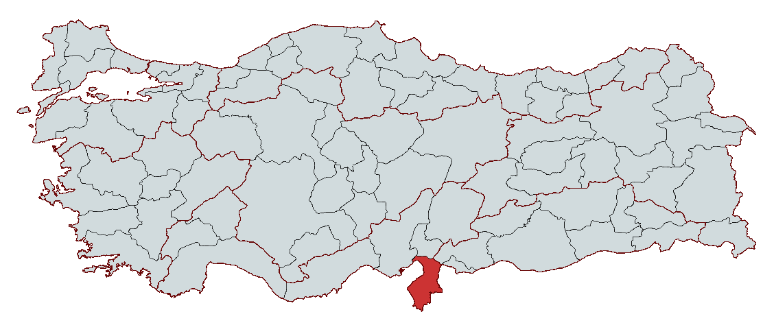
Hatay
Region | Mediterranean Region | ||||||||
|---|---|---|---|---|---|---|---|---|---|
Provincial Center | Antakya | ||||||||
Area | 5,524 km² | ||||||||
Population | Approximately 1,686,043 (2023) | ||||||||
Climate | Mediterranean Climate (Mild and rainy winters, hot and dry summers) | ||||||||
Prominent Tourist Areas | Habib-i Neccar Camii, Hatay Archaeology Museum, Saint Pierre Church, Uzun Çarşı, Payas Castle, Titus Tunnel, Harbiye Waterfalls | ||||||||
Governor | Mustafa Masatlı | ||||||||
Mayor | Mehmet Öntürk | ||||||||
Hatay, located in the south of Türkiye, has been a crossroads of various civilizations throughout history and has reached the present day as a city distinguished by its cultural, historical, and geographical richness. With its Mediterranean coastline, fertile lands, and strategic location, Hatay is an important center for trade, agriculture, and industry. The city, whose history extends thousands of years back, was founded along the Orontes River and has been a significant settlement since the Ancient Age. Hatay bears traces of different civilizations from the Hellenistic, Roman, Byzantine, Islamic, Seljuk, and Ottoman periods and continues to preserve this rich heritage today.
With its multicultural structure, Hatay is one of Türkiye’s most colorful cities. The city, where different religious communities have lived together for centuries, holds great significance for faith tourism due to its mosques, churches, and synagogues. Hatay’s cuisine, awarded the title of “City of Gastronomy” by UNESCO, is renowned worldwide for its unique flavors. Developed in terms of industry and trade, Hatay serves as the hub of economic activity, particularly through the Port of İskenderun and organized industrial zones. Severely damaged by the earthquakes of 6 February 2023, Hatay has entered a recovery process through joint efforts of the state and the public.

Hatay Antakya City Center
Hatay was established on the slopes of Habib Neccar Hill along the Orontes River, with the earliest settlement traces dating back to 8000 BCE. The city’s history is also associated with Habib al-Najjar, a figure of great importance in Islamic tradition. The region has served throughout history as a major center of trade and culture and has been home to various civilizations. In the 4th century BCE, a settlement named Antigonia existed in the same area. However, King Seleucus I of the Seleucid Empire destroyed Antigonia and founded Antiocheia (modern-day Antakya) on 30 May 300 BCE. This city became the capital of the Seleucid Empire and emerged as a major center during the Hellenistic period. Defne (Harbiye) was designated as the city’s sacred area, where large temples were constructed.
With the decline of the Hittites, the Assyrians gained dominance over the Hatay region in the 13th century BCE and brought it under their control. The ancestors of the Turkmen/Oghuz, the Sakas, under their leader Oghuz Han, captured Antakya in the mid-7th century BCE, which they named Batık Şehir. They remained there for 18 years before departing in 626 BCE.
In 550 BCE, the Persians rose to power in the Middle East and took control of Antakya and the Hatay region. In 333 BCE, Alexander the Great defeated the Persians at the Battle of Issus near Dörtyol, seized the region, and advanced through the Amanos Mountains into the Amik Plain. After Alexander’s death, the region was divided among his generals, and in 300 BCE, Seleucus I founded Antiocheia (modern Antakya). During this period, Antakya became a major cultural and commercial center.
In 64 BCE, Antakya became part of the Roman Empire and served as the capital of the province of Syria. Throughout the Roman period, the city became a major commercial hub due to its location at the intersection of important trade routes. By the 1st century CE, Antakya had become the third largest city in the empire after Rome and Alexandria. Large structures such as theaters, aqueducts, hippodromes, and baths were constructed. It was among the first cities to implement street lighting.
Antakya holds a significant place in Christian history. The sending of Saint Barnabas from the Jerusalem community to Antakya in 38 CE, followed by the arrival of Paul, and the first use of the term “Christian” to describe the community of former idol worshippers, established the city as a sacred center for Christians. From the 5th century onward, it became a patriarchal seat. Frequent earthquakes, particularly the major ones in 526 and 528 CE, caused widespread destruction.
During the Islamic conquests, Abu Ubayda ibn al-Jarrah, one of Caliph Umar’s commanders, captured Antakya in 638 CE after the Battle of Yarmouk, incorporating the city into Islamic lands. Under the Umayyads and Abbasids, Antakya developed as a major center of learning and culture. In 968 CE, it was recaptured by Byzantine Emperor Nikephoros II Phokas and remained under Byzantine rule for nearly a century.
In 1084, it was conquered by Süleyman Şah, founder of the Anatolian Seljuk State. However, during the Crusades, it was captured by Crusaders in 1098 and became the seat of the Principality of Antioch. Crusader rule ended in 1268 when Mamluk Sultan Baybars recaptured the city and returned it to the Islamic world. In 1516, Ottoman Sultan Yavuz Sultan Selim incorporated Hatay into Ottoman territories following the Battle of Marj Dabiq.
During the Ottoman period, Antakya was administered as a district (sancak) under the Aleppo province and developed as a regional center of trade and production. Numerous mosques, caravanserais, and baths were constructed during this era. Antakya experienced peace and stability under Ottoman rule, but faced increasing foreign interference and economic challenges toward the end of the 19th century.
Following the collapse of the Ottoman Empire after World War I, Antakya was occupied by the French in 1918. Under the Ankara Treaty signed between Türkiye and France on 20 October 1921, Antakya became part of French-mandated Syria.
After France granted independence to Syria in 1936, Hatay’s status became contentious. As a result of Türkiye’s diplomatic efforts, Hatay was declared an independent state in 1938, and on 2 September 1938, Tayfur Sökmen was elected as Hatay’s first president. On 29 June 1939, the Hatay Assembly voted unanimously to join Türkiye, and on 23 July 1939, French forces withdrew from the region.
After Hatay joined Türkiye, Antakya continued to develop as the provincial capital. As of 2021, the city’s population reached 400,000, and it stands out for its historical and cultural richness. The major earthquakes of 6 February 2023 caused severe damage to the city, but reconstruction efforts are progressing rapidly. Antakya continues to exist as a vital cultural heritage site, preserving traces of numerous civilizations from antiquity to the present.
Hatay Province lies in southern Türkiye along the eastern coast of the İskenderun Gulf. It is bordered by the Mediterranean Sea to the west, Syria to the south and east, Adana to the northwest, Osmaniye to the north, and Gaziantep to the northeast. Hatay consists of the districts of Antakya, Altınözü, Arsuz, Belen, Defne, Dörtyol, Erzin, Hassa, İskenderun, Kırıkhan, Kumlu, Payas, Reyhanlı, Samandağ, and Yayladağı. Its total area, excluding lakes, is 5,524 km²; 46.1% of the province consists of mountains, 33.5% of plains, and 20.4% of plateaus.
The surface features of Hatay exhibit diversity due to tectonic movements. Geological formations from the Lower Paleozoic to the present day are found within the province’s boundaries. Mesozoic ophiolites are common in the Southern Amanos Mountains, Paleozoic and Mesozoic limestones in the Central Amanos Mountains, and Tertiary limestones in the south and southeast. The Amik Plain and coastal plains are covered with alluvial deposits.
The most prominent landform is the Amanos Mountains, extending in a northeast-southwest direction, with their highest peak known as Mığır Tepe (2,240 m). The Amik Plain to the east is the province’s most fertile agricultural area. The Orontes Delta Plain, coastal plains along the İskenderun Gulf (İskenderun, Dörtyol, Payas, Erzin), and the Kuseyr Plateau at elevations of 400–900 m are other significant landforms. Isolated elevations such as Keldağ (1,730 m) are found in the south.
Hatay experiences a Mediterranean climate, with hot, dry summers and mild, rainy winters. Annual average temperatures range from 15.1 to 20 °C. The highest recorded temperature was 43.9 °C on 26 August 1962, and the lowest was −14.6 °C on 15 January 1950. Annual precipitation varies between 562.2 and 1,216.3 mm, with the highest rainfall occurring in winter months and the lowest in summer. Due to the Amanos Mountains’ perpendicular orientation to air currents from the sea, the area east of Dörtyol receives an average annual rainfall of about 1,500 mm.
The most important river in Hatay is the Orontes River, which originates in the Bekaa Valley of Lebanon, crosses the Türkiye-Syria border, and flows into the Mediterranean Sea at Samandağ after passing through Antakya. The river’s total length is 556 km, of which 94 km lie within Türkiye’s borders. Major tributaries include Küçükkaraçay, Büyükkaraçay, Afrin, and Karasu streams.
Hatay has no large natural lakes. The former Amik Lake was drained to convert it into agricultural land. Today, small lakes such as Gölbaşı Lake in Kırıkhan and Yenişehir Lake in Reyhanlı exist. Additionally, reservoir lakes such as Yarseli and Yayladağı are present in the province.
Hatay is a region rich in soil diversity. The most common soil types are red-brown Mediterranean soils, red Mediterranean soils, brown forest soils, colluvial soils, and alluvial soils. Red-brown Mediterranean soils predominate in areas with dense maquis and forests, while brown forest soils are found in regions with higher rainfall.
Due to climatic conditions, the natural vegetation of the province originally consisted of forests, but many forested areas have been destroyed and replaced by maquis communities. Low shrubs such as myrtle, laurel, carob, zakkum, delice, and wild olive are widespread. In areas where maquis has also been degraded, garig—dense woody plant communities—have formed. Protected forest areas are dominated by species such as pine, black pine, fir, oak, and juniper. In the area of the Amanos Mountains east of Dörtyol, characteristic Black Sea climate trees such as beech, hazelnut, and linden can be found.
The largest mountain range in Hatay is the Amanos Mountains, which include significant peaks such as Mığır Tepe (2,240 m), Kuşçu Tepe (2,076 m), Kızıldağ (1,700 m), and İkiztepe (1,668 m). The Amanos Mountains stretch 175 km in length and vary in width from 15 to 30 km. The most important pass is the Belen Pass at 660 m elevation. Other significant mountains within the province include Musa Dağı near Samandağ, El-Mansuriye Dağı in Yayladağı district, and Kızıldağ in the west.
Transhumance is an important activity in Hatay. High meadows (yaylas) are located at elevations of 800–1,000 m along the slopes of the Amanos Mountains. The best-known yaylas are Belen, Atik, Zorkun, and Güzelyayla (Soğukoluk). On the slopes of Keldağ facing the Orontes Valley, extensive plateaus at elevations of 350–400 m are found.
The most important plain in Hatay is the Amik Plain, located at the provincial center. Covering an area of 119,350 hectares, it is the largest and most productive agricultural area in the province. Other plains include İskenderun, Dörtyol, Payas, Erzin, and Arsuz, located around the İskenderun Gulf. The valley systems formed by the Orontes River and its tributaries significantly contribute to Hatay’s agricultural production. The Amik Plain, in particular, is highly productive due to its alluvial soils accumulated over time.
Hatay is one of the oldest settlement areas in Anatolia, with evidence of human activity dating back to the 3rd millennium BCE. However, reliable population data is available only from 1940 onward. As of 31 December 2023, Türkiye’s total population was 85,372,377, and Hatay’s population was 1,544,640. In terms of total population, Hatay ranks 13th among Türkiye’s 81 provinces.
Population Growth Rate: In 2023, Türkiye’s annual population growth rate was 1.1 per thousand, while Hatay recorded a rate of −87.6 per thousand. With this decline, Hatay ranks 80th among the 81 provinces in terms of annual population growth.
Population by Age Group: In Türkiye, 68.3% of the population is aged 15–64. In Hatay, 65.89% (1,017,917 people) are aged 15–64, 25.62% (395,878 people) are aged 0–14, and 8.47% (130,845 people) are aged 65 and over.
Population Density: In Türkiye, the population density is 110 people per square kilometer, while in Hatay it is 265. This places Hatay 7th among the 81 provinces in terms of population density.
The earthquakes centered in Kahramanmaraş on 6 February 2023 caused massive destruction and population displacement in Hatay. Thousands of buildings collapsed, tens of thousands of people lost their lives or were injured, and hundreds of thousands were forced to migrate. Prior to the earthquakes, Hatay was one of Türkiye’s fastest-growing provinces. In 2023, it experienced the most significant population decline, with a growth rate of −87.6 per thousand. Population density fell from 289 people per square kilometer in 2022 to 265 in 2023. Major population outflows occurred in densely populated urban areas such as Antakya, Defne, Samandağ, and İskenderun, while migration in rural areas and less affected districts remained limited. Although many residents of Hatay were forced to relocate to neighboring provinces and major cities, reconstruction efforts by the state and civil society organizations continue, and a gradual return of the population to the city is expected.
Hatay consists of 15 districts. Based on 2023 data, the populations of the districts are as follows:
The most populous district is Antakya, while the least populous is Kumlu.
Hatay, influenced by various civilizations throughout history, is a city renowned for its rich cultural heritage. This city, where different religious communities have coexisted, is a major center for faith tourism. In addition, it offers opportunities for thermal tourism, highland tourism, and visits to historical sites.
Hatay is a city where the call to prayer, church bells, and synagogue chants resonate together, and where different religions coexist peacefully. In Antakya and other parts of the city, mosques, churches, and synagogues are found side by side, reflecting Hatay’s cultural and religious diversity.

Habib-i Neccar Mosque
Armenian Places of Worship
Antakya Synagogue: Estimated to have been built in the 1700s, it houses a 500-year-old handwritten Tevrat.
Museum of Medicinal and Aromatic Plants:
Hatay is home to over 300 endemic plant species. The Museum of Medicinal and Aromatic Plants, opened in 2012, exhibits 280 medicinal and aromatic plants.
First Lead Museum: Located in Dörtyol, the museum displays wax figures, documents, and historical weapons from the National Struggle period.
Hatay Archaeology Museum: It houses the world’s largest mosaic collection. The exhibition halls, completed in 2018, contain artifacts from the Neolithic period to the Roman era.
Kurşunlu Han: Built in 1660 by Köprülü Mehmet Paşa. After restoration, it now hosts various commercial activities.
Uzun Çarşı: This bazaar, with its Ottoman-era origins, is famous for traditional crafts and local products.
Hatay possesses a rich culinary culture shaped by eight millennia of history and its multicultural character. Awarded the title of “UNESCO City of Gastronomy” in 2017, Hatay cuisine is recognized worldwide for its unique flavors and recipes.
Gastronomic Heritage: Hatay cuisine is distinguished by the extensive use of fresh vegetables, olive oil, legumes, and cereals typical of Mediterranean cooking. Unique flavors are created through the use of various spices and herbs. Cooking methods such as boiling, frying, grilling, stewing, and roasting are widely employed.
Signature Dishes
Cold Mezes
Desserts and Cookies
Künefe: One of the most iconic symbols of Hatay cuisine, künefe is made with fine kataifi pastry and flavored with unsalted Hatay cheese. Served on copper trays and soaked in syrup, künefe is a cherished dessert among locals. The production and consumption of künefe in Antakya represent a broad cultural tradition.

Hatay Künefe
Hatay’s economy is based on agriculture, industry, and trade. Thanks to its fertile lands, advanced industrial infrastructure, and ports, it serves as a central hub for numerous economic activities.
Hatay has abundant agricultural production due to its fertile soils and irrigation facilities. Modern agricultural techniques are widely used, resulting in the cultivation of a wide variety of crops. Major agricultural products include wheat, barley, rice, lentils, cotton, peanuts, tomatoes, eggplant, pepper, beans, and onions. In addition, Hatay is prominent in citrus production, particularly known for its Dörtyol oranges. Other fruits such as plum, apricot, pomegranate, almond, fig, and grape are also produced in large quantities.
Although the livestock sector declined in the past due to the conversion of pasturelands into agricultural fields, it has recently experienced a revival. Sheep, goat, and cattle farming are common. Beekeeping is also well-developed, and the honey produced is of high quality. Despite its long coastline, the fishing industry has not developed sufficiently, and most of the fish caught are consumed domestically.
Hatay is rich in forest resources, with 38% of its area covered by forests and maquis. Each year, significant quantities of firewood, industrial timber, and resin are harvested from these forests.
The mining sector includes deposits of chromium, copper, lead, iron, magnesite, marble, manganese, and dolomite. However, the primary active mineral extracted in the province is dolomite. Dolomite operations in Payas produce materials used in iron smelting, glass manufacturing, and the nitrogen industry. Some oil reserves have been identified in the İskenderun Gulf, but no large-scale commercial deposits have yet been discovered.
Hatay’s industrial sector is concentrated especially in the İskenderun region. The Port of İskenderun, one of Türkiye’s largest and busiest ports, serves the iron and steel, construction materials, food, and automotive industries. İSDEMİR, one of Türkiye’s largest iron and steel plants, is located in İskenderun and employs tens of thousands of people. The plant produces raw iron, steel billets, pig iron, and coke.
Hatay’s Organized Industrial Zones (OSB) enhance industrial production and provide employment. Textiles, food processing, machinery manufacturing, chemical industry, and furniture production are among Hatay’s leading industrial sectors. Additionally, factories producing cotton, soap, oil, flour, fertilizer, textiles, leather, furniture, and agricultural tools contribute to the economy. In recent years, new sectors such as electrical appliances, automotive spare parts, and packaging have begun to develop.
Hatay holds a strategic position in terms of logistics. Its Mediterranean coastline and proximity to the Middle East make it a key node in trade.
Road Network: The E-5 highway, connecting Europe, Anatolia, the Middle East, and South Asia, passes through Hatay. The Antakya–Reyhanlı road links to Aleppo in Syria, while the Kahramanmaraş–Antakya highway connects Hatay to Southeastern Anatolia.
Railway: A branch line from the Adana–Kahramanmaraş railway reaches İskenderun. The railway is primarily used for freight transport.
Sea Transport: The Port of İskenderun, the third largest export and import port in Türkiye after Istanbul and İzmir, is one of the most important trade hubs in the Eastern Mediterranean. It plays a major role in commercial shipments between Çukurova, Central Anatolia, and Middle Eastern countries.

Hatay İskenderun Port
Pipelines: The Batman–İskenderun pipeline transports crude oil from Batman to processing facilities in Dörtyol, from where it is shipped by tanker to refineries across the country.
Air Transport: Hatay Airport is of major importance for both domestic and international air travel.
Hatay provides services through coordinated central and local governance. The governorship, as the representative of the central government, ensures public order and security throughout the province, while the Metropolitan Municipality and district municipalities carry out activities related to the provision of local services, infrastructure projects, and the implementation of social programs.
The central administration of Hatay Province is managed by the governor, as the representative of the central government within the administrative structure of the Republic of Türkiye. The governor is responsible for ensuring the harmonious and effective operation of state institutions and implementing central government policies and laws. The governor also holds critical responsibilities such as maintaining public order, coordinating security services, and managing crises during extraordinary situations.
On 26 June 2023, Mustafa Masatlı was appointed as Governor of Hatay by Presidential Decree. Since assuming office, Governor Masatlı has continued his efforts in the areas of provincial development, security, and the effective delivery of public services.
Hatay has metropolitan status, and local administration is carried out by the Hatay Metropolitan Municipality. The Hatay Metropolitan Municipality manages administrative affairs in areas such as infrastructure, transportation, environmental planning, and social services. In the local elections held on 31 March 2024, Mehmet Öntürk of the Justice and Development Party (AK Party) won the Hatay Metropolitan Municipality mayoralty with 44.48% of the vote. Lütfü Savaş of the Republican People’s Party (CHP) came second with 44.05% of the vote.
In addition to the Metropolitan Municipality, the AK Party won mayoral positions in 8 districts, the Republican People’s Party (CHP) in 4, the Workers’ Party of Türkiye (TİP) in 1, the Nationalist Movement Party (MHP) in 1, and the Great Unity Party (BBP) in 1.
Antakya Belediyesi. "Antakya Tanıtım – Ekonomik ve Coğrafi Yapı." Accessed February 15, 2025.https://www.antakyatb.gov.tr/AntakyaTanitim/EkonomikveCografiYapi/tabid/4251/Default.aspx.
Antakya Ticaret ve Sanayi Odası. "Hatay Tarihi." Accessed February 15, 2025.https://www.antakyatso.org.tr/tr/genel-sayfa/hatay/hatay-tarihi-49.html
Coğrafya Gen.tr. "Hatay Ekonomi." Accessed February 15, 2025.https://www.cografya.gen.tr/tr/hatay/ekonomi.html
Hatay Büyükşehir Municipality. "Hatay’s History." Accessed February 15, 2025.https://hatay.bel.tr/sayfa/hatayin-tarihi
Hatay Valiliği. "Sosyal ve Coğrafi Durum." Accessed February 15, 2025.http://www.hatay.gov.tr/sosyal-ve-cografi-durum.
Hatay İl Kültür ve Turizm Müdürlüğü. "Hatay Coğrafya." Accessed February 15, 2025.https://hatay.ktb.gov.tr/TR-201496/cografya.html
Hatay İl Kültür ve Turizm Müdürlüğü. "Hatay Genel Bilgiler." Accessed February 15, 2025.https://www.kulturportali.gov.tr/turkiye/hatay/genelbilgiler
Islamic Encyclopedia. "Antakya." *TDV İslâm Ansiklopedisi.* Accessed February 15, 2025.https://islamansiklopedisi.org.tr/antakya.
Ministry of Culture and Tourism. "Medeniyetler Sofrası: Hatay." Accessed February 15, 2025.https://www.kulturportali.gov.tr/portal/medeniyetlersofrasihatay
NTV. "6 Şubat Depremlerinin Ardından Bölgedeki Nüfusta Düşüş." Accessed February 15, 2025.https://www.ntv.com.tr/galeri/turkiye/6-subat-depremlerinin-ardindan-bolgedeki-nufusta-dusus%2Cyc0vZSpdpkGta1JrFFS2tg?utm.
Nüfusune.com. "Hatay Nüfusu." Accessed February 15, 2025.https://www.nufusune.com/hatay-nufusu
Turk Maarif Ansiklopedisi. "Antakya." Accessed February 15, 2025.https://turkmaarifansiklopedisi.org.tr/antakya.
Türkiye İstatistik Kurumu. "CIP Portalı." Accessed February 15, 2025.https://cip.tuik.gov.tr/.
Şehrim Hatay. "Hatay’dan Kareler." Accessed February 15, 2025.https://hatay.bel.tr/sayfa/hataydan-kareler.

Hatay
Region | Mediterranean Region | ||||||||
|---|---|---|---|---|---|---|---|---|---|
Provincial Center | Antakya | ||||||||
Area | 5,524 km² | ||||||||
Population | Approximately 1,686,043 (2023) | ||||||||
Climate | Mediterranean Climate (Mild and rainy winters, hot and dry summers) | ||||||||
Prominent Tourist Areas | Habib-i Neccar Camii, Hatay Archaeology Museum, Saint Pierre Church, Uzun Çarşı, Payas Castle, Titus Tunnel, Harbiye Waterfalls | ||||||||
Governor | Mustafa Masatlı | ||||||||
Mayor | Mehmet Öntürk | ||||||||
History
Foundation and Early Periods
Assyrian and Oghuz Period (13th Century BCE–626)
Persian and Hellenistic Period (550–64 BCE)
Roman and Byzantine Period
Islamic and Turkish Rule
Ottoman Period and French Occupation
Republican Era and Present Day
Geography
Location
Geological Structure and Landforms
Climate
Rivers and Lakes
Soil Structure and Vegetation
Mountains and High Meadows
Plains and Valleys
Demographic Structure
Demographic Structure After the 6 February Earthquakes
Population Distribution by District
Tourism and Culture
Faith Tourism
Mosques
Christian Places of Worship
Jewish Places of Worship
Külliyes
Castles
Museums
Shopping Areas
Hatay Cuisine and Gastronomic Culture
Hatay Economy and Economic Activities
Agriculture and Livestock
Forestry and Mining
Industry and Trade
Transportation and Logistics
Administration