


This article was automatically translated from the original Turkish version.
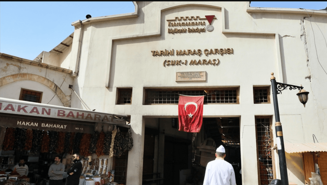
Kahramanmaraş, situated at the crossroads of a vast hinterland encompassing southern Anatolia, the Eastern Mediterranean, and the Arabian Peninsula, is home to one of its historic commercial structures. The bazaar is located within the old urban center, south of Kahramanmaraş Castle and surrounding the Ulu Camii, representing a classic example of the Ottoman covered bazaar system organized in a multi-tiered arasta layout. The structure acquired its present form in the late 19th century and suffered partial damage during the earthquake on 6 February 2023.
Kahramanmaraş developed an institutional urban structure beginning in the 15th century under the Dulkadiroğulları Beylik, during which the construction of the Ulu Camii and the commercial structures organized around it fostered the growth of the city’s internal commercial area. From the early 16th century onward, the commercial district took shape around Sûk-i Maraş (today’s Belediye Çarşısı) and the Eski Bedesten. By the late 16th century, a classical Ottoman bazaar centered on the Aşağı (Yeni) Bedesten emerged, with the Kapalı Çarşı developing as a southern extension of this commercial zone.
According to written sources, the Kapalı Çarşı evolved through four main construction phases.
The Kapalı Çarşı occupies an area measuring approximately 89.37 meters in length and 38.83 meters in width. It is bounded by the Yeni Bedesten to the north, the Taş Han and Kazazlar-Mazmanlar Çarşısı to the east, the Bakırcılar Çarşısı to the south, and Atatürk Bulvarı to the west. The ground level slopes gently, descending at a gradient of 3–4 percent from north to south and 5–6 percent from east to west. The structure was built using rubble masonry, with wall thicknesses ranging from 0.45 to 0.96 meters. Materials include rubble stone and roughly dressed stone, with cut stone preferred for arches and supports.
The Kapalı Çarşı comprises the Bezirgânlar, Kavaflar, Alacacılar arastas, and the now-vanished Köşkerler Arastası. The Bezirgânlar and Kavaflar arastas extend in a north-south direction, with the transition corridor linked to the Alacacılar Arastası. The arastas are covered with cradle and cross vaults. The Dua Kubbesi is an elevated structure resting on a four-cross-vaulted base. Skylights are integrated into the vaults, providing natural illumination. No traces of chimneys or hearths have been found. Today, the roof is covered with concrete slabs, corrugated metal sheets, and membrane materials, which pose both visual and structural problems.
The shops within the bazaar vary in size, ranging from an average of 4.08 m x 5.50 m to 1.50 m x 1.72 m. The Bezirgânlar Arastası contains 23 shops on the eastern side and 22 on the western side; the Kavaflar Arastası has 22 shops on the east and 21 on the west. The original plan of the Alacacılar Arastası included seven shops on each side, but the structure was later subdivided, with some sections repurposed as storage spaces. The Köşkerler Arastası once housed around 40 shops but was entirely demolished in the mid-20th century. Today, a total of 115 shops are active within the Kapalı Çarşı.
Basements have been identified in certain sections of the bazaar; however, a systematic basement layout cannot be confirmed. Archaeological excavations of the foundation structure are required to determine their extent. The facades feature aluminum, PVC, iron joinery, and various modern additions, which negatively affect the architectural integrity of the building.
Bozkurt, Tolga, and Ercan Aksoy. “Kahramanmaraş Kapalı Çarşı.” *Sanat Tarihi Dergisi* 32, no. 2 (October 2023): 711–739. https://doi.org/10.29135/std.1298288
T.C. Ministry of Culture and Tourism. "Kapalı Çarşı." *Kahramanmaraş İl Directorate of Culture and Tourism*. Accessed May 11, 2025. https://kahramanmaras.ktb.gov.tr/TR-152483/kapali-carsi.html.

No Discussion Added Yet
Start discussion for "Kahramanmaraş Covered Bazaar" article
Historical Background and Development Process
Structural Features
Spatial Organization and Use