This article was automatically translated from the original Turkish version.
+1 More
Mine Creek
Location | Karasu Türkiye Sakarya | ||||||||
|---|---|---|---|---|---|---|---|---|---|
Type(s) | Natural valley waterfall and recreation area | ||||||||
Ecosystem | Forest, stream, microclimate | ||||||||
Historical Elements | Ottoman-era stone quarries and tunnels | ||||||||
Conservation Status | Natural area planned for conservation | ||||||||
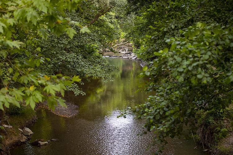
Maden Deresi and Waterfall is located within the boundaries of the Karasu district in Sakarya Province, Türkiye. This natural area is situated approximately 10 kilometers from the Karasu district center, nestled in a forested valley that merges with the lowland plains along the Black Sea coast. The region is distinguished by rock formations extending along the valley, waterfalls, springs, and a rich vegetation cover.
The Maden Deresi valley exhibits microclimatic characteristics typical of a stream bed environment. The stream flowing through the valley transforms into various small cascades and waterfalls, supporting the biological diversity of the ecosystem. The flora, particularly vibrant during spring and summer months, includes species such as plane tree, chestnut, oak, and linden. The area is also home to various bird species, reptiles, and small mammals.

Sakarya Maden Deresi (Ministry of Culture and Tourism)
The region served as a site for mining activities during the Ottoman period. This historical legacy is the origin of the valley’s name, “Maden Deresi.” Today, several stone quarries and tunnel remnants still stand, bearing witness to these industrial activities. These structures are significant both for preserving the historical landscape and for enhancing the area’s tourist appeal.
Maden Deresi and its surroundings attract considerable interest for recreational activities such as hiking, camping, climbing, photography, and waterfall tours. The area is especially favored by nature enthusiasts during weekends and holiday periods. Controlled picnic and rest areas are also provided for visitors.

Aerial View of Maden Deresi (AA)
Official statements by Sakarya Metropolitan Municipality and related public institutions indicate that various planning initiatives are underway to preserve Maden Deresi as a natural heritage site. Construction in the area has been restricted to protect its ecological balance, and environmental impact assessments have been initiated.
Projects aimed at the sustainable development of the region’s tourism potential have focused on infrastructure improvements including hiking trails, viewing platforms, directional signage, rest areas, and parking arrangements. According to recent data reported by the Anadolu Agency, efforts to establish Maden Deresi as a tourism center were largely completed by 2024.
Access to Maden Deresi and its waterfall is possible by private vehicle or public transportation from the Karasu district center. A road connection from Sakarya city center to Karasu ensures regular access to the area. Stabilized roads lead up to the entrance; however, certain sections require walking.
Maden Deresi Introduction (Onur Tokur)
Anadolu Ajansı. “Osmanlı Mirası Maden Deresi’ni Turizme Kazandıracak Projede Sona Yaklaşılıyor.” Accessed June 8, 2025. https://www.aa.com.tr/tr/kultur/osmanli-mirasi-maden-deresini-turizme-kazandiracak-projede-sona-yaklasiliyor/3294044
Anadolu Ajansı. “Sakarya'da Koruma Altındaki Maden Deresi ve Şelalesi FPV Dronla Görüntülendi.” Accessed June 8, 2025. https://www.aa.com.tr/tr/yasam/sakaryada-koruma-altindaki-maden-deresi-ve-selalesi-fpv-dronla-goruntulendi/3262816
Anadolu Ajansı. “İlkbaharla Canlanan Maden Deresi Doğaseverleri Bekliyor.” Accessed June 8, 2025. https://www.aa.com.tr/tr/yasam/ilkbaharla-canlanan-maden-deresi-dogaseverleri-bekliyor/2879809
Karasu Kaymakamlığı Governorship. "Maden Deresi." Accessed June 8, 2025. http://www.karasu.gov.tr/maden-deresi
Onur Tokur. "MADEN DERESİ | KARASU SAKARYA." Onur Tokur Youtube Kanalı. Accessed June 8, 2025. https://www.youtube.com/watch?v=USdOEMiq-PQ
Sakarya Büyükşehir Municipality. “Maden Deresi Turizm Merkezi Hâline Gelecek.” Sakarya Metropolitan Municipality. Accessed June 8, 2025. https://www.sakarya.bel.tr/a/Haber/maden-deresi-turizm-merkezi-haline-gelecek/22711
Sakarya İl Directorate of Culture and Tourism. "Maden Deresi ve Şelalesi." Sakarya Provincial Directorate of Culture and Tourism. Accessed June 8, 2025. https://sakarya.ktb.gov.tr/TR-340155/maden-deresi-ve-selalesi.html
T.C. Ministry of Culture and Tourism. "Maden Deresi Şelalesi ve Mesire Alanı." T.C. Ministry of Culture and Tourism. Accessed June 8, 2025. https://www.kulturportali.gov.tr/turkiye/sakarya/gezilecekyer/maden-deresi-selalesi-ve-mesire-alani

Mine Creek
Location | Karasu Türkiye Sakarya | ||||||||
|---|---|---|---|---|---|---|---|---|---|
Type(s) | Natural valley waterfall and recreation area | ||||||||
Ecosystem | Forest, stream, microclimate | ||||||||
Historical Elements | Ottoman-era stone quarries and tunnels | ||||||||
Conservation Status | Natural area planned for conservation | ||||||||
No Discussion Added Yet
Start discussion for "Maden Stream and Waterfall" article
Natural Structure and Ecosystem
Historical Background and Ottoman Era Remnants
Tourism Potential and Recreational Areas
Conservation Status and Environmental Planning
Recent Projects and Infrastructure Works
Access Information and Transportation Options