This article was automatically translated from the original Turkish version.
+2 More

Location | Nevşehir Province 'Kale' Hill Tatlarin Town Acıgöl District | ||||||||
|---|---|---|---|---|---|---|---|---|---|
Discovery Date | 1975 | ||||||||
Opening to Visit | 1991 | ||||||||
Historical Function | It is thought to have been a military garrison or monastery complex | ||||||||
Tatlarin Underground City is located within the boundaries of the Tatlarin township, approximately 10 kilometers north of Acıgöl district in Nevşehir Province, in Türkiye’s Central Anatolia Region. The underground city is situated on a hill known locally as “Kale.” The township of Tatlarin lies within Nevşehir Province, one of the cultural and historical centers of Cappadocia, and exhibits similarities with other underground settlements in the region. The underground city was constructed over a very extensive area.
Tatlarin Underground City (Nevşehir Governorate)
Tatlarin Underground City was first identified in 1975. Following this discovery, cleaning and restoration works were carried out, and a portion of the settlement was opened to visitors in 1991. Throughout its historical development, the site served various purposes. The size of the chambers, the large number of food storage rooms, and the presence of churches indicate that this underground city fulfilled a function beyond ordinary residential use. For this reason, Tatlarin Underground City is believed to have served as a military garrison or a monastic complex.
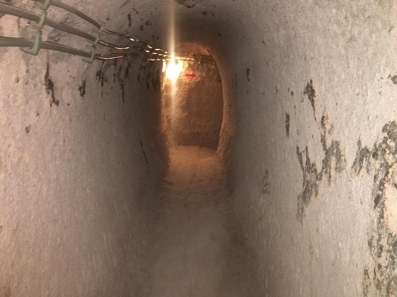
The original entrance gate has been destroyed. Today, access to the underground city is provided through two separate chambers on the western side. Additionally, entry is also possible via a curved tunnel approximately 15 meters in length. This tunnel opens into a rectangular hall with a rectangular plan, protected at its entrance by a large stone plug measuring about 1.5 meters in diameter and pierced through its center. These entrance systems demonstrate that the underground settlement was also designed with defense in mind.

Tatlarin Underground City (Ministry of Culture and Tourism)
The chambers of the underground settlement are spacious. Three skeletons were found within a niche on the right side of the main hall. This area is thought to have been used as a cemetery or prison during the Roman period and later deepened and converted into food storage pits during the Byzantine period. The niches in the settlement resemble the burial recesses found in Roman rock-cut tombs.
On the right side of the main chamber are areas used as storerooms and kitchens. A narrow, curved, and sloping corridor on the left side of the main chamber leads to a second large room. Toilets are present on both levels of the settlement. Access to the toilets is provided via L-shaped corridors, a design interpreted as intended to prevent the spread of odors. The toilet feature is found only in Tatlarin, Güzelyurt, and Saratlı underground settlements.
Another notable feature of Tatlarin Underground City is the presence of traps, 2 to 3 meters deep, placed along the corridors. Moreover, the settlement contains numerous food storage rooms and churches, suggesting that the structure may have also functioned as a military garrison or monastic complex. Most of the other churches located on the Kale site have been destroyed by natural factors.
Culture and Tourism Ministry – Museums and Archaeological Sites under theNevşehir Müze Directorate. Culture and Tourism Ministry, Nevşehir Museum Directorate. Accessed June 12, 2025. https://nevsehir.ktb.gov.tr/TR-230412/nevsehir-muze-mudurlugune-bagli-muze-ve-oren-yerleri-38-.html.
Ministry of Culture and Tourism. "Nevşehir, Tatlarin Yeraltı Şehrinde Çevre Düzenleme Çalışmalarına Yeniden Başlandı." Accessed June 12, 2025. https://kvmgm.ktb.gov.tr/TR-142052/nevsehir-tatlarin-yeralti-sehrinde-cevre-duzenleme-calismalarina-yeniden-baslandi.html.
Nevşehir Valiliği. *Tatlarin Yeraltı Şehri*. Accessed June 12, 2025. http://www.nevsehir.gov.tr/tatlarin-yeralti-sehri.
Location | Nevşehir Province 'Kale' Hill Tatlarin Town Acıgöl District | ||||||||
|---|---|---|---|---|---|---|---|---|---|
Discovery Date | 1975 | ||||||||
Opening to Visit | 1991 | ||||||||
Historical Function | It is thought to have been a military garrison or monastery complex | ||||||||
No Discussion Added Yet
Start discussion for "The Underground City of Tatlar" article
History
Structural Features