


This article was automatically translated from the original Turkish version.
+2 More
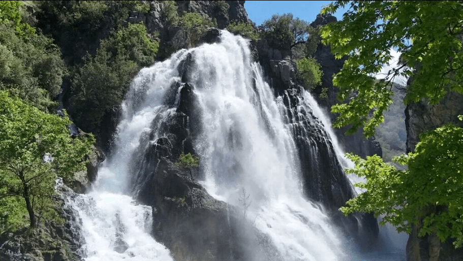
Uçansu Şelalesi (Anadolu Ajansı)
Location | Antalya Province, Gündoğmuş District | ||||||||
|---|---|---|---|---|---|---|---|---|---|
Geographical Type | Waterfall | ||||||||
Water Source | Snowmelt from the Taurus Mountains, Akdağ and Geyik Dağları | ||||||||
Transportation | Antalya–Serik–Alanya road, Gebiz–Akçapınar route | ||||||||
Activities | Nature hiking, day trip, nature tourism | ||||||||
Uçansu Waterfall is a natural waterfall formed by waters originating from the Taurus Mountains within the boundaries of Antalya Province. Located in the interior regions of Antalya, the waterfall is one of the prominent natural features due to its location, water sources, accessibility, and surrounding hiking routes.
Uçansu Waterfall is approximately 70 kilometres from the city centre of Antalya.【1】 The waterfall lies on the boundary between Kayabükü Village and Eskibağ Village and can be reached via a road branching off from the Abdurrahmanlar–Gebiz junction on the Antalya–Serik–Alanya highway. After passing through Akçapınar Village, which is administratively part of Gebiz, a route of approximately 17 kilometres must be followed.
The area where the waterfall is situated falls within the boundaries of Gündoğmuş District. It also constitutes one of the natural water sources in the upper catchment basin of the Alara River.
The name of the waterfall derives from the manner in which the water flows. The water descends in two distinct steps from a height of approximately 25 to 30 metres, gliding along rock surfaces rather than falling vertically.【2】 Due to this unique flow pattern, the waterfall is known as Uçansu.
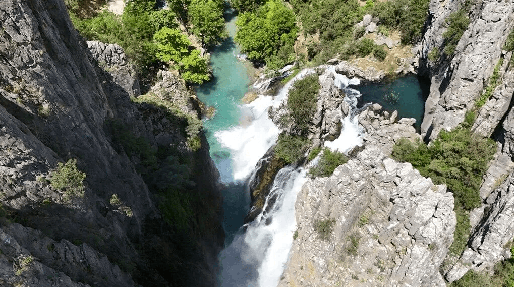
Uçansu Şelalesi (Anadolu Ajansı)
Uçansu Waterfall exhibits a two-tiered structure. Waters from the Taurus Mountains reach the lower level through two separate points within a lush green vegetation cover. The total drop of the water is approximately 50 metres. The flow does not originate from a single point but results from the convergence of waters from multiple branches.
The water feeding the waterfall originates from the high elevations of the Taurus Mountains.【3】 Meltwater from the Akdağ and Geyik Dağları regions forms the primary basis of the waterfall’s hydrological regime. Waters flowing from multiple tributaries combine to form the Alara River, which continues its course through Manavgat before emptying into the Mediterranean Sea.
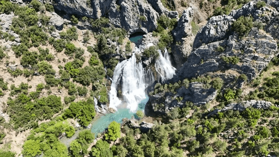
Uçansu Şelalesi ve Doğal Çevresi (Anadolu Ajansı)
The waterfall is situated within forested areas. Its surroundings are densely covered with vegetation, and the water flows through these green landscapes.
During the summer months, air temperatures in the area reach approximately 15 °C. As a result, the region exhibits climate conditions typical of alpine pastures.
Uçansu Waterfall is accessible by road. The final section of the road leading from Gebiz is stabilized. During spring, increased water volume can make vehicle access difficult in certain sections of the route, and passage may be impossible at some points.
The waterfall is located near one of the sections of the historic Silk Road.【4】 The hiking trail on the Gündoğmuş Narağacı–Ortakonuş route is approximately 10 kilometres long. Along this path, the Alara River is followed, and the hike concludes at Uçansu Waterfall.
Uçansu Waterfall has been recognized as one of the areas designated for nature tourism. Day trips and nature hikes are regularly conducted in the region. Along with the highland areas surrounding Gündoğmuş, İbradı and Akseki, it is considered a suitable location for outdoor activities and nature-based sports. Additionally, it has been included as one of the routes in organized hiking initiatives aimed at expanding tourism activities in Antalya beyond the coastal zones into the inland regions.
Anadolu Ajansı. “Antalya'da dağın içinden fışkıran Uçansu Şelalesi ziyaretçilerini ağırlıyor.” Anadolu Ajansı Foto Galeri. Accessed July 9, 2026.https://www.aa.com.tr/tr/pg/foto-galeri/antalyada-dagin-icinden-fiskiran-ucansu-selalesi-ziyaretcilerini-agirliyor/162865
Anadolu Ajansı. “Antalya'nın gizli cenneti: Uçansu Şelalesi.” Accessed July 9, 2026.https://www.aa.com.tr/tr/turkiye/antalyanin-gizli-cenneti-ucansu-selalesi-/1501824
Antalya Büyükşehir Municipality. Antalya'nın Şelaleleri. Antalya: Antalya Metropolitan Municipality Directorate of Urban History and Promotion, 2023.
T.C. Antalya Valiliği. “Saklı Cennet ‘Uçansu Şelalesi’ Doğa Severlerin Akınına Uğrayacak.” Accessed July 9, 2026.https://antalya.gov.tr/sakli-cennet-ucansu-selalesi-doga-severlerin-akinina-ugrayacak
T.C. Kültür ve Turizm Bakanlığı. “Uçansu Şelalesi.” Kültür Portalı. Accessed July 9, 2026.https://www.kulturportali.gov.tr/turkiye/antalya/gezilecekyer/ucansu-selalesi
[1]
T.C. Kültür ve Turizm Bakanlığı, “Uçansu Şelalesi,” Kültür Portalı, erişim 9 Temmuz 2026, https://www.kulturportali.gov.tr/turkiye/antalya/gezilecekyer/ucansu-selalesi
[2]
Antalya Metropolitan Municipality, *Antalya'nın Şelaleleri* (Antalya: Antalya Metropolitan Municipality Directorate of Urban History and Promotion, 2023), 20–21.
[3]
Anadolu Ajansı. “Antalya'nın gizli cenneti: Uçansu Şelalesi.” Accessed July 9, 2026.https://www.aa.com.tr/tr/turkiye/antalyanin-gizli-cenneti-ucansu-selalesi-/1501824.
[4]
T.C. Antalya Valiliği, “Saklı Cennet ‘Uçansu Şelalesi’ Doğa Severlerin Akınına Uğrayacak,” T.C. Antalya Valiliği, erişim 9 Temmuz 2026, https://antalya.gov.tr/sakli-cennet-ucansu-selalesi-doga-severlerin-akinina-ugrayacak.

Uçansu Şelalesi (Anadolu Ajansı)
Location | Antalya Province, Gündoğmuş District | ||||||||
|---|---|---|---|---|---|---|---|---|---|
Geographical Type | Waterfall | ||||||||
Water Source | Snowmelt from the Taurus Mountains, Akdağ and Geyik Dağları | ||||||||
Transportation | Antalya–Serik–Alanya road, Gebiz–Akçapınar route | ||||||||
Activities | Nature hiking, day trip, nature tourism | ||||||||
Location
Origin of the Name
Physical Characteristics
Water Sources
Natural Environment
Accessibility
Hiking Routes in the Vicinity
Nature Tourism