
Soğanlı Neighborhood is one of the neighborhoods of the Bahçelievler district, located on the European side of Istanbul. According to the latest census, its population is 66.182, making it a densely populated residential area. The neighborhood has transformed from rural lands into a residential center over time and today has a well-developed structure in terms of housing, trade, and service sectors.
Soğanlı Neighborhood is situated in the southeastern part of Bahçelievler district. Its boundaries are as follows:
The neighborhood is located close to the E-5 Highway, providing an advantageous position for transportation to other parts of Istanbul.
The history of Soğanlı Neighborhood is linked to the Kocasinan region. During the Ottoman period, the area was covered with vineyards, gardens, and farms. Additionally, the neighborhood was located on an important route connecting Istanbul to other cities in ancient times. Historical remnants of the neighborhood include the Soğanlı Fountain, of which only a replica remains today, and Mimar Sinan Street, which was formerly known as the Old Edirne Road.
Soğanlı Neighborhood is one of the neighborhoods that has received migration from different parts of Istanbul. The population distribution over the years is as follows:
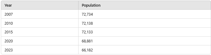
Yearly Population
The neighborhood is largely urbanized, with a predominance of young and middle-aged groups. In recent years, there has been a slow decline in population.
Soğanlı Neighborhood hosts various public and private educational institutions. Bahçelievler Anatolian Trade and Vocational High School is one of the key public high schools in the neighborhood. Füsun Yönder Anatolian High School is another institution known for its academic achievements. At the primary level, Ali Haydar Günver Primary School and Bağlar Primary School provide fundamental education to students. Additionally, the neighborhood has private educational institutions, including Özel Dört Mevsim Kindergarten.
Healthcare services in Soğanlı Neighborhood are provided through family health centers, clinics, and private healthcare institutions. The Soğanlı Family Health Center offers essential healthcare services to local residents. The Hekimbaşı Ömer Family Health Center, located on Mustafa Kemal Paşa Street, serves a large patient population. The 5th Family Health Center is another significant healthcare facility within the neighborhood.
Furthermore, family health centers in the neighboring Cumhuriyet and Siyavuşpaşa neighborhoods are frequently used by Soğanlı residents.
Soğanlı Neighborhood has several historical structures dating back to the Ottoman period:
Cultural facilities in the neighborhood include the Bahçelievler Municipality Public Library and the Soğanlı Information Center.
Soğanlı Neighborhood has a central location for urban transportation within Istanbul. It is accessible via metro, minibus, and bus routes. The main streets of the neighborhood include:
1. Mustafa Kemal Paşa Street
2. Kemal Sunal Street
3. Mimar Sinan Street
4. Old Edirne Road
5. Umut Street
6. Bağcılar Street
7. Ferit Selim Paşa Street
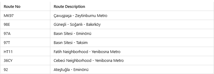
Bus Lines
Minibus lines also provide connections to key areas such as Bakırköy, Yenibosna, and Bahçelievler.
The M3 / Kayaşehir - Bakırköy Sahil metro line has its İlkyuva station located within Soğanlı Neighborhood.
Henüz Tartışma Girilmemiştir
"Soğanlı Neighbourhood" maddesi için tartışma başlatın
Geographical Location and Boundaries
History
Demographic Structure
Educational Institutions
Healthcare Services
Historical Monuments and Cultural Facilities
Main Arteries and Transportation
Bu madde yapay zeka desteği ile üretilmiştir.