Bu içerik Türkçe olarak yazılmış olup yapay zeka ile otomatik olarak İngilizceye çevrilmiştir.
+1 Daha
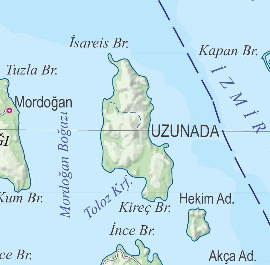
Uzunada ve İzmir Körfesi (HGM)
Uzunada is the fourth largest island in Türkiye, located in the İzmir Outer Gulf region of İzmir Province. The island is defined by its physical dimensions as well as its geological framework, which includes the Neogene basin development and volcanic-sedimentary stratigraphy in its vicinity; it is also mentioned in some historical accounts as a location of military use and naval significance. Today, there is no permanent settlement, and the island is used by the Turkish Naval Forces.

Location of Uzunada (HGM)
Uzunada has a surface area of 26.83 km² and a coastline length of 24.5 km. The geological structure of the island and its immediate surroundings consists of a stratigraphic sequence comprising products of calc-alkaline acidic to intermediate volcanism active during the Late Early Miocene, along with Middle Miocene lacustrine sediments and associated alkaline volcanics. The oldest unit in the stratigraphy is the Kocadağ Volcanoclastics, which are products of the Kocadağ volcanism characterized by calc-alkaline andesitic to dacitic outputs. This unit includes ignimbrites, pyroclastic flows of block-and-ash facies, and epiclastic deposits of lahar facies. The Foça Tuff, represented by rhyolitic ignimbrites, was emplaced in two distinct eruptive phases. During the quiescent period between these phases, coarse volcaniclastic alluvial deposits known as the Değirmentepe Member were deposited. Overlying the Foça Tuff with an unconformity is the Middle Miocene lacustrine sequence of the Urla Group. This group comprises, from bottom to top, the Beşiktepe Formation, Pırnallıada Volcanoclastics, Hekimadası Basalt, and Urla Limestone. The Beşiktepe Formation represents Middle Miocene basin-margin sedimentation and is exposed only on Uzunada.

Geological Map of Uzunada (Fikret Göktaş)
Geochronological data from units around Uzunada indicate a K/Ar age of 16.0 million years (My) for a rhyolitic dome associated with the Foça Tuff, which constrains the timing of Late Early Miocene volcanism. Samples from the Hekimadası Basalt within the Urla Group yield a K/Ar age of 14.8±0.8 My for basaltic lavas classified as trachibasalt and basaltic trachyandesite based on major element composition. Above the Hekimadası Basalt, peperite structures developed as a result of interaction between the lava flows and water-saturated sediments. Overlying this level is the transgressive Urla Limestone sequence. The Urla Limestone begins at its base with backshore mudstones, followed by nearshore deposits composed of stromatolitic oncoids and algal bioclasts. The sequence continues with conglomeratic limestones and extends to the end of the Middle Miocene.
The island appears in some historical records as “Kösten Adası (Uzun Ada).” During the spring of 1915, when the İzmir Gulf was under military threat, British forces occupied the island, deployed artillery units, and constructed an aircraft hangar. Monitor-type warships were positioned between the northeastern coast of the island and the Menemen Gulf, bringing Yenikale and surrounding batteries under fire; several structures in Urla town and along the shoreline were damaged by naval gunfire. It is noted that the small Urla Harbor lies approximately three kilometers from the town. Military troop movements and preparation activities took place on April 8, April 16, and April 17, 1916.
On the morning of May 6, as daylight broke, artillery opened fire on Kösten Harbor. The British warships anchored in the harbor weighed anchor and withdrew from the area. In response, British forces bombarded the Mordoğan Peninsula but failed to damage the coastal batteries. On the afternoon of May 13, the British monitor M 30, carrying two 12 cm and two 15 cm guns and manned by a crew of 70, entered Kösten Harbor and was hit. A boiler explosion caused the ship to catch fire and drift into the harbor, where it continued burning until the evening of May 14. On May 15–16, other batteries at Konica inflicted heavy damage on a British torpedo boat attempting to enter İzmir Harbor. In the following days, sustained fire from Konica and Mordoğan forced British forces to completely abandon Kösten Adası.
Following the military coup on September 12, 1980, several individuals were taken to the Uzunada Naval Base in İzmir. The island is visible from the Karşıyaka coastline and contains recreational facilities belonging to the Naval Forces. Those brought to the island were held there for approximately twenty days. Following the September 12 coup, Necmettin Erbakan, General Secretary of the National Salvation Party, and Alparslan Türkeş, General Secretary of the Nationalist Movement Party, were also detained on Uzunada for a period of time.
Uzunada ve İzmir Körfesi (HGM)
Henüz Tartışma Girilmemiştir
"Uzunada" maddesi için tartışma başlatın
Geographical Features
Geochronology and Numerical Age Data
Historical Significance