


This article was automatically translated from the original Turkish version.
+2 More
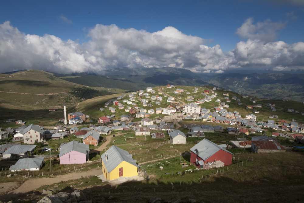
Bektaş Plateau (Giresun)
Location | Giresun Türkiye | ||||||||
|---|---|---|---|---|---|---|---|---|---|
Elevation(s) | 1600–2000 metres | ||||||||
Tourism Center Status Declaration | 1991 | ||||||||
Bektaş Yaylası is a highland located in the Giresun Province of Türkiye’s Black Sea Region. Situated approximately 56 kilometers from the city center of Giresun, the highland lies at an elevation between 1,600 and 2,000 meters. It features a plateau structure that corresponds to the rugged and forested topography of Eastern Black Sea. The name derives from the Turkish word “Bektaş,” meaning sacred mountain in Turkish mythology.
Bektaş Yaylası can be reached via several routes from the Giresun city center. The main route follows the Giresun–Evrenköy–Erimez–Yavuzkemal corridor. Additionally, three alternative routes are available:
A significant portion of these routes consists of asphalt or stabilized roads. During winter months, certain road segments may be temporarily closed due to snowfall. The condition and structure of the roads leading to the highland vary seasonally, depending on the region’s geographical and climatic characteristics.
Declared a Tourism Center in 1991, Bektaş Yaylası forms a cohesive tourism unit together with the surrounding Kulakkaya Yaylası, Melikli Obası, Kurttepe Mevkii, and Alçakbel Forest Picnic Area. The region offers natural environments suitable for activities such as hiking, camping, mountaineering, and picnicking.
Basic infrastructure services including electricity, drinking water supply, and telephone lines are available at Bektaş Yaylası. These services are essential for both residential and tourism activities on the highland. However, the continuity and capacity of these services may vary according to seasonal conditions in the region.
The climate of the highland is characteristic of the high-altitude areas of the Black Sea Region: cool and humid. Snow cover may persist in some elevated areas during early summer. Winter temperatures typically fall below zero, and snowfall is heavy. These climatic conditions support the diversity of the vegetation and natural ecosystems of the area.
Kurttepe Mevkii is one of the areas on the highland suitable for winter sports. Skiing is possible during the winter months. In summer, alternative activities such as grass sledding are practiced. Additionally, the highland and its surroundings are ideal for hiking, camping, and nature photography. The region’s topographical and climatic structure enables a variety of recreational activities throughout the year.
Bektaş Yaylası is one of the areas where the transhumance culture of the region continues. The annual Bektaş Highland Festival, held in July, is a social event featuring traditional folk dances, musical performances, and local cuisine. The festival plays a vital role in preserving the region’s cultural heritage and sustaining the transhumance tradition.
Bektaş Yaylası is surrounded by extensive forested areas. The region hosts various tree species, primarily black pine, fir, and hornbeam. The meadows around the highland are suitable for livestock farming. The vegetation includes diverse species adapted to the high altitude and humid climate. The local fauna includes various bird species, small mammals, and endemic plants.
Bektaş Yaylası is situated in the western section of the Eastern Black Sea Mountains, on a rugged plateau of volcanic origin. The geological structure of the region consists primarily of volcanic rocks. The highland has a well-developed drainage system and a topography with low risk of flooding and erosion. The landform supports the formation of water sources and natural habitats in the area.
Bektaş Yaylası (Youtube/Giresun)
Bekdemir, Ünsal, and Ünal Özdemir. “Doğu Karadeniz Bölümünde Gelişmekte Olan Yayla Turizm Merkezlerine Bir Örnek: Bektaş Yaylası / An Example to Developing Centers of Plateau Tourism in Black Sea Region: Bektaş Plateau.” *Doğu Coğrafya Dergisi* 7, no. 7 (2011). https://dergipark.org.tr/en/download/article-file/26827. Accessed May 21, 2025.
Bulancak Kaymakamlığı Governorship. "Yaylalarımız." T.C. Bulancak District Governorship Official Website. Accessed May 21, 2025.
Culture Portal. "Bektaş Yaylası." Culture Portal. Accessed May 21, 2025.
Dereli Kaymakamlığı. "Bektaş Turizm Merkezi." T.C. Dereli Kaymakamlığı Resmî Web Sitesi. Accessed May 21, 2025.
Giresun İl Kültür ve Turizm Müdürlüğü. "Bektaş Yaylası Turizm Merkezi." Giresun İl Kültür ve Turizm Müdürlüğü Resmî Web Sitesi. Accessed May 21, 2025.
YouTube. “Giresun Bektaş Yaylası – Tanıtım Filmi.” Published by Giresun. https://www.youtube.com/watch?v=udlOzx2UqCc. Accessed May 21, 2025.

Bektaş Plateau (Giresun)
Location | Giresun Türkiye | ||||||||
|---|---|---|---|---|---|---|---|---|---|
Elevation(s) | 1600–2000 metres | ||||||||
Tourism Center Status Declaration | 1991 | ||||||||
No Discussion Added Yet
Start discussion for "Bektaş Plateau (Giresun)" article
Location and Access
Tourism Center Status and Surrounding Natural Areas
Infrastructure
Climate and Natural Conditions
Nature Sports and Recreational Activities
Transhumance and Cultural Activities
Natural Structure and Ecosystem
Geological and Geomorphological Features