This article was automatically translated from the original Turkish version.
+2 More
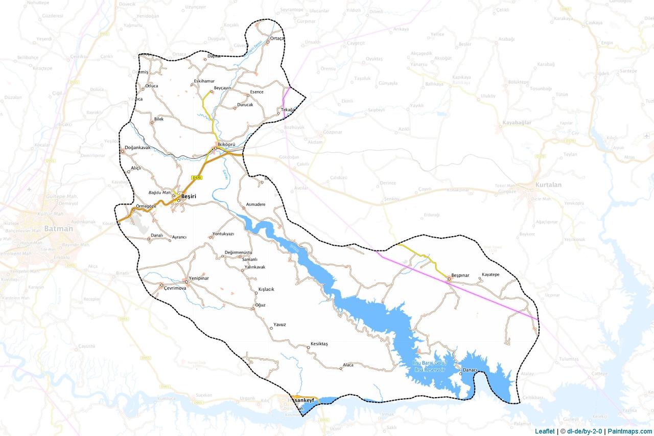
Beşiri (District)
Location | Batman | ||||||||
|---|---|---|---|---|---|---|---|---|---|
Area(s) | 889 km² | ||||||||
Neighbors | East: Siirt (Kurtalan district) North: Kozluk district South: Hasankeyf district West: Batman center | ||||||||
Beşiri is a district of Türkiye’s Batman province. Located parallel to the Garzan Çayı, with its historical past and rural settlement structure, it is one of the settlements of the Southeastern Anatolia Region. Spanning an area of 889 km², Beşiri possesses distinct administrative, geographical and social characteristics.
Beşiri’s history extends back to before the Republic. During the Ottoman period, Beşiri was known as Kobin and was a small village under the Garzan district of Siirt province. In 1926, it experienced a major hello disaster that marked a turning point. This event led to the transfer of Beşiri from the Elmedine kazas of Diyarbakır province, after which it adopted the name Beşiri and gained the status of a district under Siirt province. With Batman’s elevation to provincial status in 1990, Beşiri became a district subordinate to Batman. Throughout its history, its strategic location and the fertile agricultural lands provided by the Garzan Çayı have shaped the district’s settlement and administrative structure. Ottoman archives and local narratives contain some records on the region’s importance in agriculture and trade, but detailed archaeological studies remain limited.
Beşiri covers an area of 889 km² and is located in the eastern part of Batman province. The district’s geographical structure is defined by the valley formed by the Garzan Çayı and the surrounding plains. The Garzan Çayı is the most important natural feature influencing both the settlement pattern and agricultural activities in the district. Beşiri is bordered by Kurtalan district of Siirt to the east, Kozluk district to the north, Hasankeyf district to the south, and Batman provincial center to the west. The district’s villages are predominantly concentrated along the banks and east sections of the Garzan Çayı. Topographically, Beşiri features gently undulating terrain that offers fertile agricultural land along the tea valley. The region also includes small hills and plateaus, but high mountainous areas are limited.
Beşiri’s climate exhibits the continental characteristics typical of the Southeastern Anatolia Region. Summers are hot and dry, while winters are cold and rainy. Average temperatures reach 30–35°C in write months and can drop to around 0°C in winter months. Rainfall is concentrated mainly in winter and spring, with annual precipitation ranging between 500 and 600 mm. The presence of the Garzan Çayı creates microclimatic effects in certain areas of the district, providing higher humidity along the riverbanks.
The Plant cover is characterized by steppe and grasslands, adapted to the region’s continental climate. Along the riverbanks, poplar söğüt, willow like tree species and wetland plants are found, while herbaceous vegetation and steppe formations dominate the interior areas. Due to the extensive coverage of agricultural land, the natural vegetation has diminished in some areas, yet plant diversity continues in certain zones around the river valley. Beşiri’s ecosystem has been shaped by agricultural and livestock activities.
Beşiri has a rural and community oriented social structure. The district’s social fabric is defined by the density of villages and mezra settlements. Traditional lifestyle, family ties and local culture form the foundation of social relations. The district center and İkiköprü Beldesi serve as centers for social and cultural activities. Although education, health and social services remain dependent on the Batman provincial center, basic infrastructure services are available within the district. Local festivals, weddings and religious holidays are important elements of social life. Ethnic and cultural diversity in the region adds richness to Beşiri’s social structure, although detailed data on this aspect is limited. Communities along the Garzan Çayı that rely on agriculture and livestock determine the community structure.
Beşiri’s economy is largely based on agriculture and livestock farming. The irrigation potential of the Garzan Çayı supports the production of cereals (wheat, barley), legumes and vegetable-fruit. The fertile lands along the river form the backbone of agricultural production. Livestock farming, particularly small ruminants (sheep and goats) and large ruminant animal breeding, is widely practiced among the district’s economic activities. Dairy and meat production contribute to the local economy.
Proximity to the Batman provincial center has facilitated the development of small-scale trade and service sectors in Beşiri. Local markets exist for the sale of agricultural products, but industry activities remain limited. Although indirect effects of Batman’s petroleum industry are felt in terms of employment and commerce, Beşiri’s economy remains predominantly focused on agriculture and livestock. In recent years, agricultural modernization and irrigation projects have been among the efforts aimed at increasing economic efficiency.
Beşiri is worthy of consideration for tourism due to its natural and historical richness, but this potential has not been systematically evaluated. The Garzan Çayı is the district’s most important natural attraction. The riverbank areas are suitable for activities such as picnicking, nature walks and fishing. The landscapes formed by the river offer nature-based visitation opportunities. Historically, Beşiri’s settlement history during the Ottoman and Republican periods may serve as a subject for research for history enthusiasts, but there is limited information regarding prominent archaeological sites or tourist structures in the region.
Beşiri’s proximity to the Batman provincial center and to the historically and touristically significant area of Hasankeyf provides convenient access. Hasankeyf’s cultural heritage and the appeal of the Tigris River can make Beşiri a transit point for day trips. Developing tourism infrastructure in the district (accommodation, guided services) could contribute to the growth of tourism activities.
Beşiri’s demographic structure reflects a profile dominated by rural settlements. The district comprises 54 villages and 62 mezras attached to these villages. The majority of the population resides in these villages and mezras. The district center consists of 6 neighborhood, while İkiköprü Beldesi has 3 neighborhoods, totaling 9 neighborhoods. Population data is not specified in available sources, but considering Batman’s general demographic characteristics, Beşiri’s population is estimated to be between 20,000 and 30,000 (this requires verification against official data as of 2025).
The majority of the population earns its livelihood through agriculture and livestock farming. The youth population is relatively high, but due to limited employment opportunities, migration to the Batman provincial center or other major cities is observable. Education levels are basic in rural areas, while more developed schools are found in the district center. Health services are provided in the district center and beldes, but advanced medical care continues to depend on the Batman provincial center.
Beşiri is a district under Batman province and administratively has two municipalities: Beşiri District Municipality and İkiköprü Town Municipality. The district has a total of 9 neighborhoods: six in the district center and three in İkiköprü Town. The 54 villages and their 62 attached mezras constitute the rural administrative structure of the district. Most villages are located along the Garzan Çayı and in the eastern part of the district due to the agricultural advantages provided by the river. The district’s administrative governance is carried out under the authority of the Batman Provincial Governorship. The district governorship, municipalities and village headmanships play a fundamental role in local administration.
Beşiri Belediyesi. "Doğal Güzellikler." Accessed April 19, 2025. https://besiri.bel.tr/icerik/dogal-guzellikler.
Beşiri Belediyesi. "Kentsel Doku." Accessed April 19, 2025. https://besiri.bel.tr/icerik/kentsel-doku.
Beşiri Belediyesi. "Kültürel Zenginlik." Accessed April 19, 2025. https://besiri.bel.tr/icerik/kulturel-zenginlik.
Beşiri Belediyesi. "Tarihçe." Accessed April 19, 2025. https://besiri.bel.tr/icerik/tarihce.
Beşiri Kaymakamlığı. "İdari Yapısı." Accessed April 19, 2025. http://besiri.gov.tr/idari-yapisi.

Beşiri (District)
Location | Batman | ||||||||
|---|---|---|---|---|---|---|---|---|---|
Area(s) | 889 km² | ||||||||
Neighbors | East: Siirt (Kurtalan district) North: Kozluk district South: Hasankeyf district West: Batman center | ||||||||
History
Geographical Structure
Climate and Vegetation
Social Structure
Economic Structure
Tourism Potential
Demographic Structure
Administrative Structure