This article was automatically translated from the original Turkish version.
+2 More
Elevation(s) | 30–120 metres | ||||||||
|---|---|---|---|---|---|---|---|---|---|
Conservation Status | Philippines' Third National Geological Monument | ||||||||
Location | Bohol Island Philippines Central Visayas | ||||||||
Ecosystem Characteristics | Habitats Diverse Vegetation Tropical Karst Area | ||||||||
Geological Structure | Hemispherical Hills Conical Karstic | ||||||||
Cultural Significance | Cultural Landscape Showing Human Settlements and Agricultural Adaptations | ||||||||
UNESCO Status | Philippines' First and Only UNESCO Global Geopark in 2024 | ||||||||
Number of Hills | Approximately 1776 | ||||||||
Chocolate Hills are distinctive conical karst formations located on the island of Bohol in the central Visayas region of the Philippines. This natural structure consists of approximately 1,776 hills formed through prolonged erosion and dissolution of limestone bedrock. The area holds significant geomorphological importance and influences the region’s hydrological and ecological balance. The Chocolate Hills are protected as a Natural Monument under national legislation and are monitored under environmental management practices.
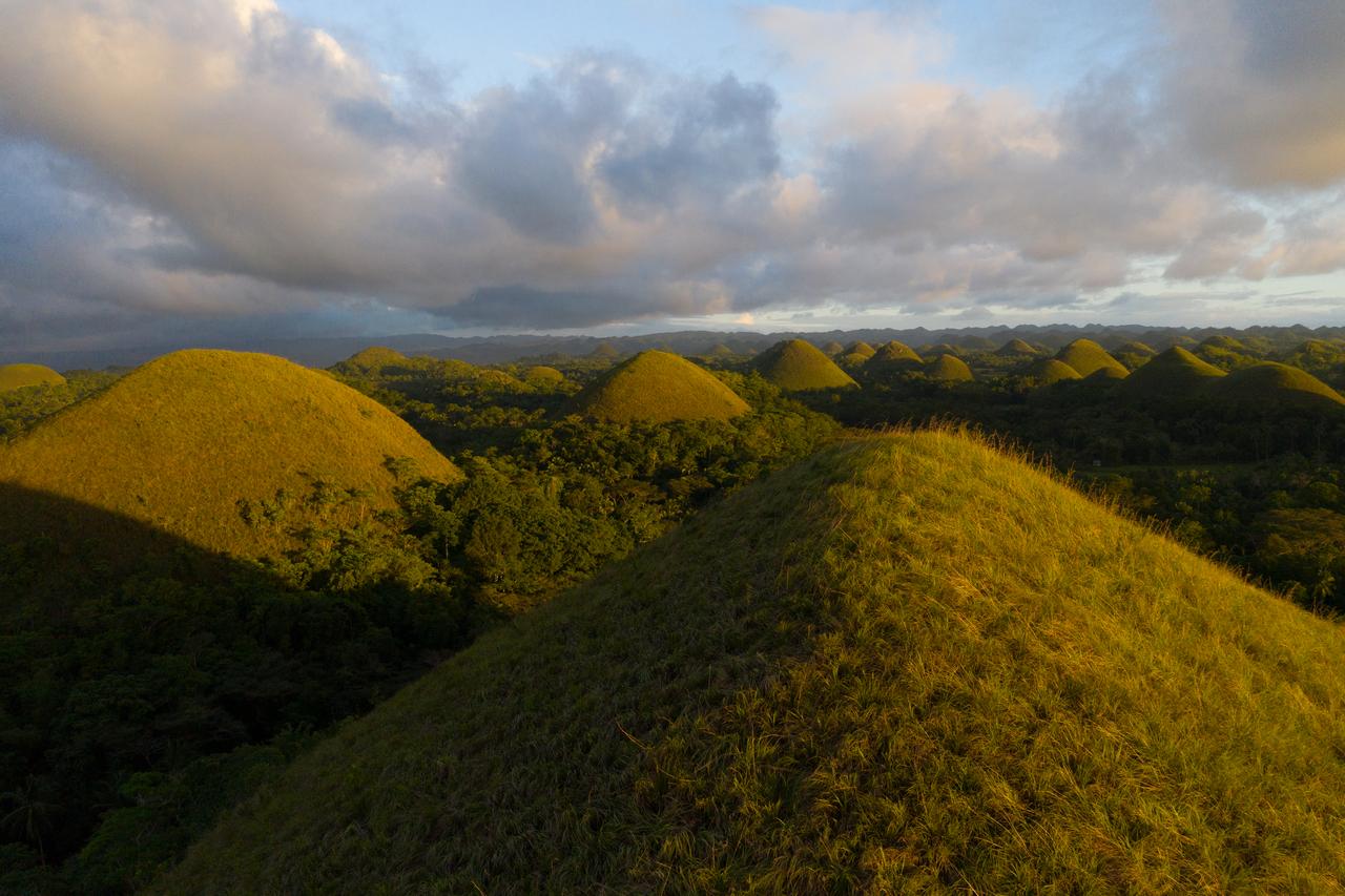
Chocolate Hills (Flickr)
The Chocolate Hills are situated in the central part of Bohol Island within the Central Visayas region of the Philippines. The area lies northeast of the city of Tagbilaran and falls within the municipal boundaries of Carmen, Batuan, Sagbayan and Sevilla. This karst landscape, encompassing approximately 1,776 hills, features closely spaced conical and hemispherical structures.【1】 The hills vary in height between 30 and 120 metres.【2】 This density and regularity form the defining characteristic of the region’s landscape and represent a clear indicator of its karstic morphology.
Geographically, the Chocolate Hills lie within the tropical climate zone, and the soil composition consists largely of thin, stony soils formed by the dissolution of limestone. The surface has been shaped by rainfall and subsurface water movement, with agricultural and settlement areas found in the valleys between the hills. The base of the hills typically features gently sloping farmland and patches of natural vegetation. The topographic arrangement and karstic structure directly influence the pattern of water infiltration, groundwater aquifers and drainage systems; these features play a vital role in ecosystem services and local community access to water and agricultural resources.
The Chocolate Hills are composed of limestone layers formed through ancient marine sedimentary processes. Long-term chemical dissolution and erosion have resulted in the emergence of conical and hemispherical hill structures on the surface. Cracks and cavities in the limestone, expanded by water and rainfall, define the area’s karstic character. These structural features form the fundamental elements shaping the irregular topography.
The valleys and transitional zones between the hills have been shaped by subsurface water movement and surface runoff. Cavities formed by the dissolution of limestone deposits guide drainage systems and influence land use. The complexity of the geological structure enhances the landscape’s morphological diversity and determines how water circulates through the terrain. Additionally, this structure plays a critical role in ecosystem processes and natural habitat distribution.
Due to its karstic terrain and variable microhabitats, the Chocolate Hills support a variety of plant species. Shrubs and ground-cover plant communities dominate the ridges and slopes, while more moisture-adapted species concentrate in the valleys. This variation enhances the area’s microecosystem diversity and creates unique habitats for the local flora. The natural vegetation, which also affects soil stability and surface water infiltration, contributes to slowing erosion processes.
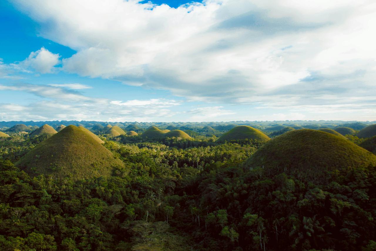
Chocolate Hills (Pexels)
In terms of animal communities, the hills and intervening habitats provide living space for birds, reptiles and small mammals. Karstic fissures and cavities serve as shelters for various invertebrate species. The region indirectly contributes to the sustainability of local water sources by regulating water infiltration into the ground and plays a role in supplying clean water for agricultural use. Furthermore, the structural diversity of the landscape supports the continuity of ecosystem processes and enables the maintenance of the area’s ecological functions.
The Chocolate Hills were declared the third National Geological Monument of the Philippines on 18 June 1988.【3】 This status aims to preserve the area’s natural structure and karstic landscape features. Conservation is implemented through a management approach requiring the participation of various stakeholders, primarily local communities. However, the rapid and limited implementation of conservation measures has occasionally led to conflicts between landowners and local residents. Management plans prioritize the protection of the karstic structure and natural landscape, and legal regulations prohibit mining, large-scale agricultural interventions and land degradation within the area.
One of the challenges in the management process is delays in enforcing the legal framework and insufficient public awareness among local residents. Local governance conducts public awareness programs, land use regulations and environmental monitoring mechanisms to ensure the protection and sustainable use of the area. In addition, collaboration between national and local authorities to update the conservation status and develop appropriate management plans serves as a vital tool for safeguarding both the ecological integrity and social harmony of the region.
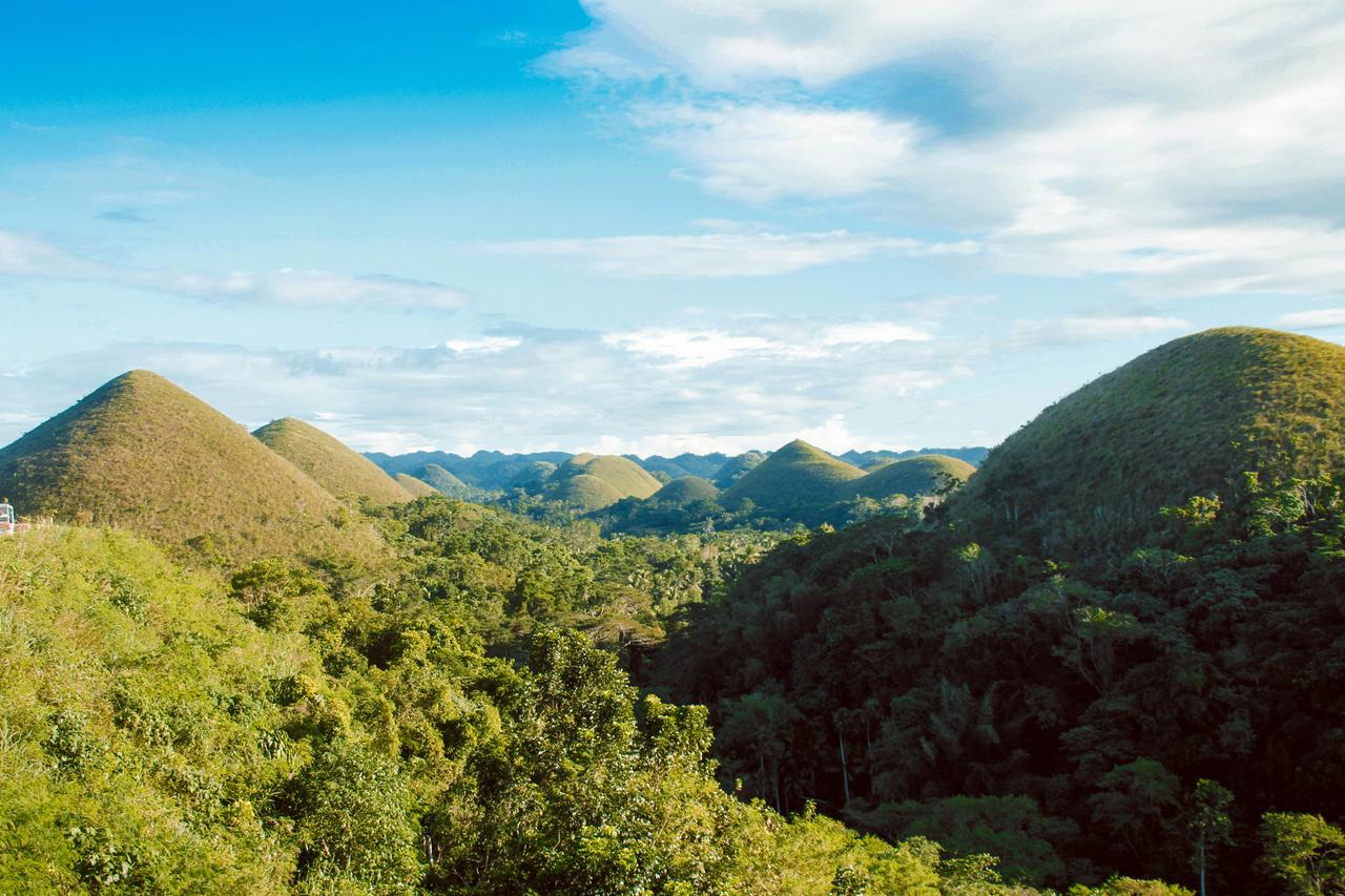
Chocolate Hills (Pexels)
The Chocolate Hills hold cultural value as an area in dynamic interaction with the local communities and historical landscape of Bohol Island. The region can be studied as an example of a landscape shaped by traditional agricultural and settlement patterns. At the national and international levels, recognizing the cultural and geological significance of the hills, in 2024 the Province of Bohol was declared the Philippines’ first and only UNESCO Global Geopark, with the Chocolate Hills designated as its premier geological site.【4】 This designation formally underscores the region’s scientific and cultural heritage value and provides guidance for conservation, education, tourism and environmental awareness initiatives.
LambdaScorpii. "Tepeler, Çikolata hills, Filipinler görseli." Pixabay. Accessed March 2, 2026. https://pixabay.com/tr/photos/tepeler-%c3%a7ikolata-hills-filipinler-3634445/
Law, Nic. “Ağaçlarla çevrili Tepelerin Manzarası.” Pexels. Accessed March 2, 2026. https://www.pexels.com/tr-tr/fotograf/agaclarla-cevrili-tepelerin-manzarasi-757430/
Law, Nic. “Ağaçlarla çevrili Tepelerin Manzarası.” Pexels. Accessed March 2, 2026. https://www.pexels.com/tr-tr/fotograf/agaclarla-cevrili-tepelerin-manzarasi-757444/
Law, Nic. “Ağaçlarla çevrili Tepelerin Manzarası.” Pexels. Accessed March 2, 2026. https://www.pexels.com/tr-tr/fotograf/agaclarla-cevrili-tepelerin-manzarasi-757450/
Municipality of Carmen, Bohol. "Chocolate Hills." Municipality of Carmen Tourism site. Accessed March 2, 2026. https://carmen-bohol.gov.ph/tourist-spot/chocolate-hills/
Salomon, Jean Noel. "A Mysterious Karst: the 'Chocolate Hills' of Bohol (Philippines)." *Acta Carsologica* 40, no. 3 (2011): 429-444. Accessed March 2, 2026. https://ojs.zrc-sazu.si/carsologica/article/view/3
Tura, Rogel. "Bohol's Chocolate Hills." Flickr. Accessed March 2, 2026. https://www.flickr.com/photos/1ightchaser/50056563836/
UNESCO National Commission of the Philippines. "Global Geopark – Philippines." UNESCO National Commission of the Philippines website. Accessed March 2, 2026. https://www.unesco.gov.ph/global-geopark-philippines/
UNESCO World Heritage Centre. "Chocolate Hills Natural Monument." *Tentative List.* sy. 5024. Accessed March 2, 2026. https://whc.unesco.org/en/tentativelists/5024/
Urich, Peter B., Michael J. Day, and Fiona Lynagh. "Policy and Practice in Karst Landscape Protection: Bohol, the Philippines." *The Geographical Journal* 167, no. 4 (2001): 305–323. Accessed March 2, 2026. https://www.academia.edu/10945733/Policy_and_practice_in_karst_landscape_protection_Bohol_the_Philippines
[1]
UNESCO World Heritage Centre, "Chocolate Hills Natural Monument," Tentative List, no. 5024, Last Accessed: 2 March 2026, https://whc.unesco.org/en/tentativelists/5024/
[2]
Jean Noel Salomon, "A Mysterious Karst: the “Chocolate Hills” of Bohol (Philippines),” Acta Carsologica 40, no. 3 (2011): 433, Last Accessed: 2 March 2026, https://ojs.zrc-sazu.si/carsologica/article/view/3
[3]
UNESCO World Heritage Centre, "Chocolate Hills Natural Monument," Tentative List, no. 5024, Last Accessed: 2 March 2026, https://whc.unesco.org/en/tentativelists/5024/
[4]
Municipality of Carmen, Bohol, "Chocolate Hills," Municipality of Carmen Tourism website, Last Accessed: 2 March 2026, https://carmen-bohol.gov.ph/tourist-spot/chocolate-hills/
Elevation(s) | 30–120 metres | ||||||||
|---|---|---|---|---|---|---|---|---|---|
Conservation Status | Philippines' Third National Geological Monument | ||||||||
Location | Bohol Island Philippines Central Visayas | ||||||||
Ecosystem Characteristics | Habitats Diverse Vegetation Tropical Karst Area | ||||||||
Geological Structure | Hemispherical Hills Conical Karstic | ||||||||
Cultural Significance | Cultural Landscape Showing Human Settlements and Agricultural Adaptations | ||||||||
UNESCO Status | Philippines' First and Only UNESCO Global Geopark in 2024 | ||||||||
Number of Hills | Approximately 1776 | ||||||||
Location and Geographic Features
Formation Process and Geological Structure
Biodiversity and Ecosystem Services
Conservation and Management Practices
Cultural Significance
