This article was automatically translated from the original Turkish version.
+1 More
Location | Ağrı | ||||||||
|---|---|---|---|---|---|---|---|---|---|
Period of Construction | Early Iron Age | ||||||||
Civilization to Which It Belongs | Kingdom of Urartu | ||||||||
Castle Type | Stone-based defensive castle on Sarp cliffs | ||||||||
Structural Elements | and channels water cisterns temple remains rock-cut tombs Stone rampart walls | ||||||||
Doğubeyazıt Urartu Kalesi is an early Iron Age defensive structure built on steep basalt cliffs at the Belleburç site, northeast of the Doğubayazıt district in Ağrı Province. It is one of the best-preserved Urartian remains in the region, exhibiting a multi-layered settlement pattern with rooms carved into the rock, cisterns, and burial niches.
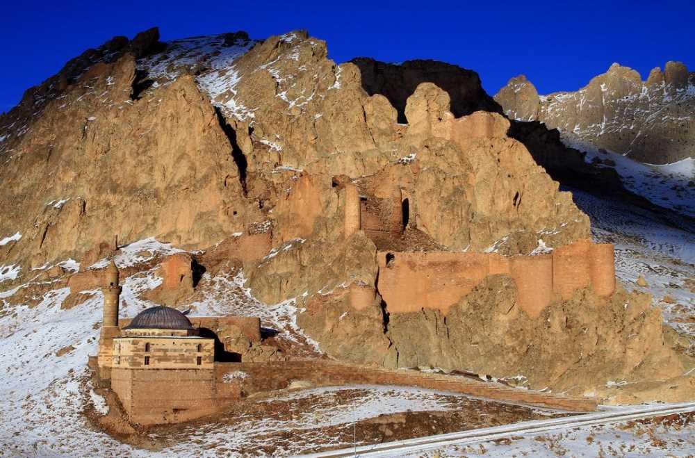
Doğubeyazıt Urartu Kalesi (Türkiye Culture Portal)
The fortress overlooks the Doğubayazıt Plain from a commanding position, controlling the pass route between the Aras Mountains and the Greater and Lesser Ağrı Mountains, as well as the İpek Geçidi. Its location at the junction of the ancient Silk Road, which connected the plain to the Caucasian Pass to the north, rendered it a key element in Urartu’s eastern frontier defense and trade security. The region’s abrupt topographical elevation, abundant water sources, and rich pastures made it a focal point of intensive settlement throughout the Early Iron Age.
As the Urartian Kingdom consolidated power in the Lake Van basin at the beginning of the 9th century BCE, its northern expeditions reached the Doğubayazıt-Iğdır corridor, where it encountered local Iron Age polities such as the Erikua Kingdom. This expansion led to the incorporation of regional fortresses into Urartian administration. The fortress was likely constructed to safeguard the kingdom’s eastern borders and maintain control over vital trade routes.

Location of Doğubayazıt and Expansion Routes of the Urartian Kingdom (Dergipark)
Wall System and Entrance: The natural rock ridge was reinforced with multi-tiered ashlar and rubble stone walls. The main entrance is a narrow gateway accessed via a zigzagging ramp. The use of large, partially worked stone blocks with irregular joints, characteristic of Urartian masonry, is clearly evident in the structure.
Internal Layout: On the fortress plateau are foundations of temples, rock-cut tombs, cylindrical-circular cisterns, and storage spaces.
Defensive Elements: The steep western and southern slopes naturally form precipitous cliffs; only the northeast side features a defensive wall, approximately 160 meters in length.
Within Urartian layers, archaeologists have identified ceramic fragments with deeply grooved rims and dark glazes; rock-cut cisterns and channels; observation terraces; and multi-chambered rock-cut tombs. These findings indicate that the fortress served the Urartian military and administrative system between the 9th and 7th centuries BCE. Nearby low kurgan-type burials point to burial customs associated with rural settlements under the fortress’s control.
Doğubayazıt Urartu Kalesi, together with Akçukur and Kalus fortresses, forms the first line of defense along the strategic corridor extending from the Tendürek Pass to the Lake Van basin. These fortresses jointly controlled access to the Silk Road and the Caucasian route, ensuring Urartu’s border security and tax regulation.
Sections of the fortress walls retain elevations exceeding two meters; however, some stone blocks have been dislodged or removed. Archaeological excavations have been limited, and illegal dig pits have left visible signs of damage. The site is designated as a protected area by the Ministry of Culture and Tourism and requires detailed scientific excavation and conservation efforts.
Ablak, Şüheda. “Doğubayazıt Ovası’nın Güneybatısı’nda Akçukur Kalesi ve Nekropolü.” *Amisos* 1, Özel Sayı (2022): 1–8. Accessed July 7, 2025. https://dergipark.org.tr/tr/download/article-file/2165682.
Ministry of Culture and Tourism of the Republic of Turkey. “Doğubayazıt Urartu Kalesi.” Ağrı İl Kültür veTurizm Müdürlüğü. Accessed July 7, 2025. https://agri.ktb.gov.tr/TR-393057/dogubeyazit-urartu-kalesi.html.
Ministry of Culture and Tourism of the Republic of Türkiye. "Urartu Kalesi - Ağrı." *Kültür Portalı*. Accessed July 7, 2025. https://kulturportali.gov.tr/turkiye/agri/gezilecekyer/urartu-kalesi.
Location | Ağrı | ||||||||
|---|---|---|---|---|---|---|---|---|---|
Period of Construction | Early Iron Age | ||||||||
Civilization to Which It Belongs | Kingdom of Urartu | ||||||||
Castle Type | Stone-based defensive castle on Sarp cliffs | ||||||||
Structural Elements | and channels water cisterns temple remains rock-cut tombs Stone rampart walls | ||||||||
No Discussion Added Yet
Start discussion for "Doğubeyazıt Urartu Castle" article
Location and Strategic Importance
Historical Background
Architectural and Structural Features
Archaeological Findings
Role within the Regional Defense Network
Current Condition and Conservation
