This article was automatically translated from the original Turkish version.
+1 More
Saklıkent Waterfall
Distance(s) | Approximately 5 km to Yığılca | Approximately 40 km to Düzce center | ||||||||
|---|---|---|---|---|---|---|---|---|---|
Elevation(s)(Text) | 10 meters | ||||||||
Activities | Hiking, picnicking, photography, short camping | ||||||||
Forest Types | Oak, hornbeam, linden, oak, pine | ||||||||
Location | Yağcılar Village Düzce Yığılca | ||||||||
Located within the boundaries of the Yığılca district of Düzce province, near Yağcılar Village. It is approximately 5 kilometers from the Yığılca district center and 40 kilometers from the Düzce provincial center. Access to the waterfall is provided via a stabilized road leading from Yığılca center toward Yağcılar; it is also regarded as a transit point along the interconnected nature walking trails of Yedigöller.
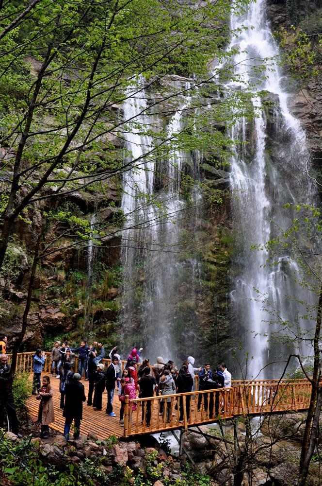
The Saklıkent Waterfall derives its name “saklı” (hidden) from its geographically concealed position within the valley. The waterfall, which cascades from a height of approximately 10 meters, is situated within a narrow valley surrounded by dense forests. The area offers a microclimatic environment that is cool and humid. The surroundings of the waterfall feature a unique landscape characterized by natural rock formations, moss-covered ground, and sloping topography. These characteristics confer both visual and ecological value to the site.

Saklıkent Şelalesi (Düzce Provincial Directorate of Culture and Tourism)
According to the Düzce Walking Trails Guidebook, the area surrounding Saklıkent is enveloped by a Black Sea forest structure composed primarily of hornbeam, oak, linden, and pine trees. This mixed forest cover of deciduous and coniferous species provides habitat for local bird species, amphibians, and small mammals. The immediate vicinity of the waterfall is also botanically significant due to its moist microclimatic conditions, supporting a variety of ferns, mosses, and riparian vegetation.
The Saklıkent Waterfall is utilized as a day-trip and picnic destination through environmental improvement initiatives coordinated by the Düzce Governorship and the Provincial Directorate of Culture and Tourism. Wooden seating areas, viewing platforms, nature walking paths, and informational signage have been installed around the waterfall to create a controlled and accessible experience for visitors. Additionally, the waterfall route provides a natural setting suitable for nature photography and picnicking.
The waterfall can be integrated with walking trails located to the east and south of Yığılca. According to the Düzce Walking Trails Guide, the Saklıkent route lies along the path connecting Yığılca–Hebeler–Yağcılar–Saklıkent and is suitable for nature walking over a distance of approximately 7 kilometers. Due to the limited presence of directional signage along this route, visitors are advised to use GPS devices, maps, and appropriate footwear.

Saklıkent Şelalesi (Düzce Provincial Directorate of Culture and Tourism)
Ministry of Culture and Tourism of the Republic of Türkiye. "Saklıkent Şelalesi – Gezilecek Yerler." Accessed June 29, 2025. https://www.kulturportali.gov.tr/turkiye/duzce/gezilecekyer/saklikent-selalesi-1
T.C.Düzce Yürüyüş Directorate of Culture and Tourism. *Düzce Walking Trails Information Brochure*. Accessed June 29, 2025. https://duzce.ktb.gov.tr/Eklenti/59104,duzce-yuruyus-12x22-tr-08-ocak-2018pdf.pdf?0
T.C.Düzce İl Directorate of Culture and Tourism. "Saklıkent Şelalesi." Accessed June 29, 2025. https://duzce.ktb.gov.tr/TR-236607/saklikent-selalesi.html
Saklıkent Waterfall
Distance(s) | Approximately 5 km to Yığılca | Approximately 40 km to Düzce center | ||||||||
|---|---|---|---|---|---|---|---|---|---|
Elevation(s)(Text) | 10 meters | ||||||||
Activities | Hiking, picnicking, photography, short camping | ||||||||
Forest Types | Oak, hornbeam, linden, oak, pine | ||||||||
Location | Yağcılar Village Düzce Yığılca | ||||||||
No Discussion Added Yet
Start discussion for "Saklıkent Waterfall" article
Natural Structure and Landscape Character
Ecosystem Components and Biodiversity
Tourism Use and Recreational Potential
Integration with Walking Trails and Access Recommendations