This article was automatically translated from the original Turkish version.
+1 More
Karakoçan (District)
Province(s) | Elazığ | ||||||||
|---|---|---|---|---|---|---|---|---|---|
District Formation | 1936 | ||||||||
Region(s) | Eastern Anatolia Region | ||||||||
Area(s) | 1085 km² | ||||||||
Elevation (Altitude) | 1090 m | ||||||||
Climate(s) | Continental (semi-humid cold and snowy winters) dry summers | ||||||||
Karakoçan is a district located in the Eastern Anatolia Region of Türkiye and is administratively subordinate to Elazığ Province. It was established in 1936 within the framework of administrative reorganizations during the Republican era. The district was formed by merging the nahiyehs of Ohi and Başyurt (formerly Lahan), which were previously under Palu, and the Çan nahiyeh, which belonged to the Kiğı district of Bingöl. The name Karakoçan, after which the district is named, is also the name of one of its central villages. However, Tepe Köyü was chosen as the district center due to its more favorable topographical conditions.
Karakoçan District lies on a tectonic plain formed along the Karakoçan Fault Zone within the Upper Euphrates Basin. The plain is covered by extensive Holocene alluvial deposits and is surrounded by high mountains. To the north are the Gaz and Çopur Mountains; to the northeast is Kurucadağı (2372 m); to the east are the Hesesek Mountains; and to the south are the Mazı Mountains. These mountainous areas consist of basalt, andesite, and tuff. The average elevation of the plain ranges between 1085 and 1110 meters.
The main rivers in the district are Peri Suyu, Ohi Çayı, and Kuşçu Çayı. In addition to the Kalecik Irrigation Reservoir located on the Kalecik Creek within the district boundaries, there are also Seyrantepe, Özlüce, Pembelik, Kalecik, and Tatar dams. The plain has a gentle slope toward the southwest and exhibits a simple topography. Due to climatic conditions and limited irrigation opportunities, the range of agricultural products is narrow.
The dominant climate type in Karakoçan is continental climate. According to data from 1975 to 2006, the annual average temperature is 11.1°C, the lowest average temperature is -3.1°C, and the highest average temperature is 24.1°C. The annual thermal amplitude reaches up to 27.2°C. The average annual precipitation is 654.5 mm, with 60% occurring in spring and autumn. During winter months, the number of snowfall days exceeds 35, and average snow depth reaches 8.5 cm. According to the Thorntwaite climate classification, the region exhibits a semi-humid, mesothermal climate with summer water deficiency.
In the northern parts of the district, oak forests constitute the natural climax vegetation. However, over historical periods, anthropogenic steppe formations have become widespread due to increasing settlement. Although arable land is limited, cereal production is practiced. Limited irrigated agriculture has been possible since the construction of the Kalecik Dam, which came into operation in 1975. However, some agricultural lands have been abandoned due to urban expansion.
The settlement history of Karakoçan extends back to the Chalcolithic period. Archaeological investigations conducted in Bahçecik Village in 1987 revealed evidence of Urartian settlement in the region. In 1990, an inscription dating to the Urartian period was discovered in the same area. Throughout history, the district has been under the rule of the Hittites, Urartians, Medes, Persians, Romans, Byzantines, Seljuks, Akkoyunlus, and Ottomans. The first entry of Islamic armies into the region occurred during the caliphate of Hz. Ömer, when troops commanded by Khalid ibn al-Walid conquered Kiğı.
As of 2019, the total population of Karakoçan is 28,142. The district comprises one central municipality, one town municipality (Sarıcan), 88 villages, and 52 hamlets, totaling approximately 150 settlement units. The total number of households in the district is approximately 3,540.
Economic activities are primarily based on agriculture and animal husbandry. The main agricultural products are cereals. Income from labor migration abroad—particularly to European countries such as Germany since the 1960s—has been channeled into housing investments within the district. Sugar beet production has declined over time, and animal husbandry has become the primary source of livelihood. Additionally, Karakoçan-specific highland honey and dairy products are sold in provincial and regional markets.
Among the district’s tourist attractions, Golan Hot Springs hold significant importance. The springs, located along the Peri Çayı, are known for their thermal waters, which are believed to be beneficial for rheumatism, neuritis, skin diseases, and women’s health conditions. The area around Kalecik Dam, Güzel Baba Forest, and Beyaz Çeşme Recreation Area are frequently visited natural sites by the local population. Moreover, local pilgrimage sites such as Garip Baba, Pir Cemal Abdal, Güzel Baba, and Sefkar Baba hold religious significance.
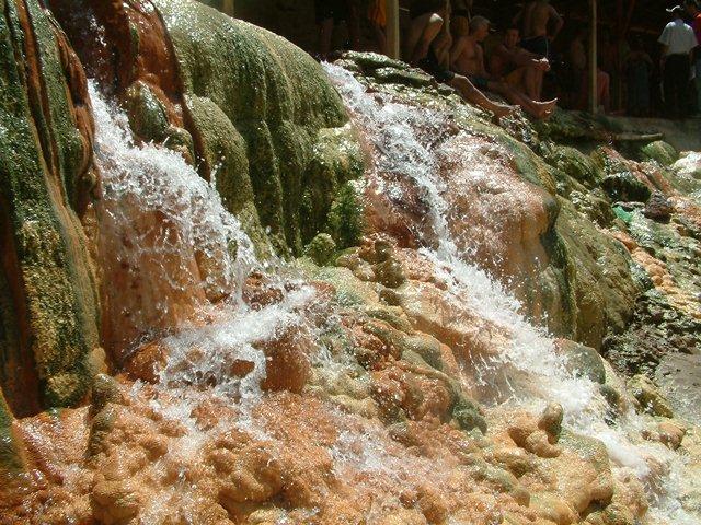
Golan Hot Springs (Ministry of Culture and Tourism)
Karakoçan’s urbanization process accelerated after it gained district status in 1936. The urban population, which was only 324 in 1940, reached 14,923 by 1990. Rapid construction occurred after the 1960s due to the influence of migrant workers. As of 2007, the town had approximately 2,242 houses and 3,798 apartments. The New Neighborhood stands out in terms of housing density. Most of the housing units in Karakoçan were built by workers employed abroad.
The dominant function in Karakoçan District is the service sector (88.6%). Agriculture accounts for 8.6% and industry for 2.8%. The service sector has led to the development of public institutions, healthcare facilities, educational institutions, and commercial areas. The district hosts a state hospital, community health centers, and various health units. In education, the district includes boarding regional schools, Imam Hatip high schools, primary education institutions, and a public education center. Commercial activities are concentrated mainly along Cumhuriyet Avenue and its surroundings. The weekly neighborhood market is an important commercial event, attracting shoppers from neighboring districts. Karakoçan has a total of 785 commercial enterprises, distributed across retail, wholesale, and service sectors.
Atasoy, Ahmet. “Şehir Coğrafyası Açısından Karakoçan (Elazığ).” *Mustafa Kemal Üniversitesi Sosyal Bilimler Enstitüsü Dergisi* 8, no. 16 (2011): 159–183. Accessed June 20, 2025. https://dergipark.org.tr/tr/download/article-file/182985
Elazığ Belediyesi. “Karakoçan.” Elazığ Municipality Official Website. Accessed June 20, 2025. https://www.elazig.bel.tr/kent-rehberi/karakocan/228/
Elazığ Governorship. "Karakoçan." *T.C. Elazığ Valiliği Resmî Web Sitesi*. Accessed June 20, 2025. http://www.elazig.gov.tr/karakocan
Elazığ İl Directorate of Culture and Tourism. "Karakoçan." Ministry of Culture and Tourism of the Republic of Turkey. Accessed June 20, 2025. https://elazig.ktb.gov.tr/TR-58511/karakocan.html
Karakoçan District Governorship. "Tarihçe." *T.C. Karakoçan Kaymakamlığı Resmî Web Sitesi*. Accessed June 20, 2025. http://www.karakocan.gov.tr/tarihce
Turkiye İstatistik Kurumu (TÜİK). "Adrese Dayalı Nüfus Kayıt Sistemi Sonuçları, 2019." TÜİK Kurumsal. Accessed June 20, 2025. https://data.tuik.gov.tr/bulten/index?p=adrese-dayali-nufus-kayit-sistemi-sonuclari-2019-33705#:~:text=T%C3%9C%C4%B0K%20Kurumsal&text=T%C3%BCrkiye’de%20ikamet%20eden%20n%C3%BCfus,433%20bin%20861%20ki%C5%9Fi%20oldu
Karakoçan (District)
Province(s) | Elazığ | ||||||||
|---|---|---|---|---|---|---|---|---|---|
District Formation | 1936 | ||||||||
Region(s) | Eastern Anatolia Region | ||||||||
Area(s) | 1085 km² | ||||||||
Elevation (Altitude) | 1090 m | ||||||||
Climate(s) | Continental (semi-humid cold and snowy winters) dry summers | ||||||||
No Discussion Added Yet
Start discussion for "Karakoçan (District)" article
Geographical Location and Physical Structure
Climate
Natural Vegetation and Land Use
Historical Development
Settlement Structure and Demography
Economic Structure
Tourism and Cultural Heritage
Urbanization and Construction
Urban Functions
