This article was automatically translated from the original Turkish version.
+1 More
Samandere Şelalesi Tabiat Anıtı (Gülcan Acar. Kültürportalı)
The district of Kaynaşlı, located immediately south of the city center of Düzce, possesses a rich topographical structure and forested landscape due to its position within the transition zone between the Black Sea and Central Anatolia regions. Thanks to these characteristics, various nature walking trails of different lengths and difficulty levels have been established in the district. The diversity of natural landscapes and ease of access have made Kaynaşlı one of Düzce’s key focal points for nature tourism.
This long-distance route spans approximately 18 km, beginning in Kaynaşlı district and extending through Eğrelti Plateau, Yeniyurt Plateau, and Sinekli Plateau to reach the Abant region at the border with Bolu. Along the route, travelers encounter plateau transitions, forest paths, and seasonal meadows. This trail is open year-round and requires high physical fitness and navigation skills. The use of a GPS device, map, and sturdy hiking boots is recommended.
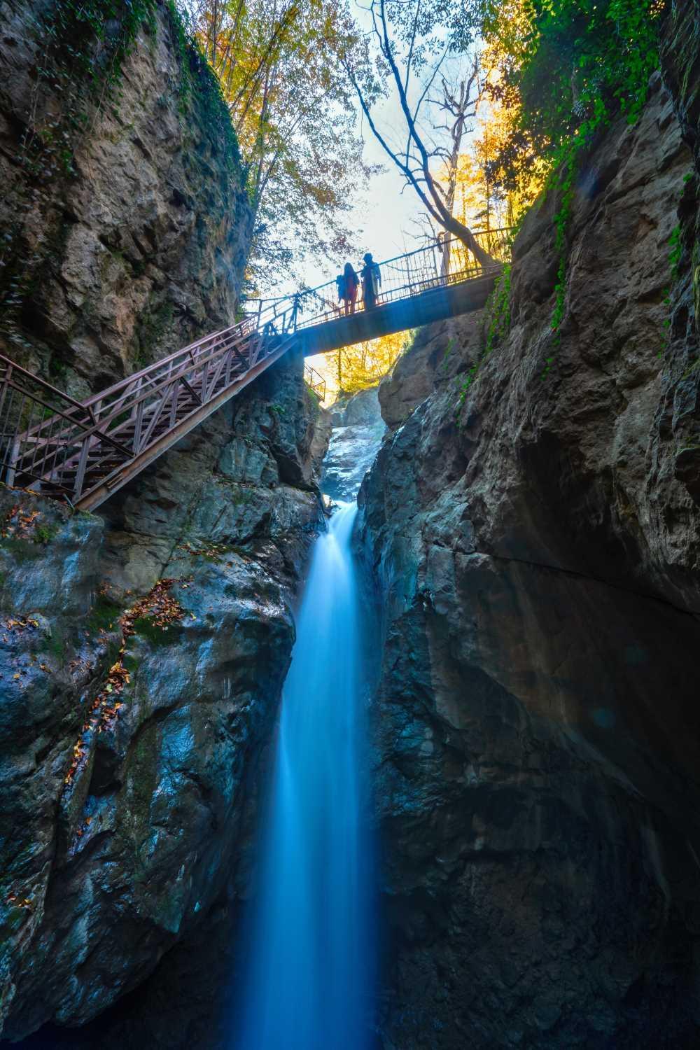
This approximately 18 km one-way trail offers a mixed experience combining natural and cultural elements. Walkers traverse through forests dominated by species such as beech, fir, hornbeam, chestnut, and holm oak, culminating at Samandere Waterfall, one of Turkey’s officially registered natural monuments. Additionally, settlements like Sazköy, inhabited by populations of Caucasian origin, provide hikers with opportunities for ethnographic observation.

Samandere Waterfall (Gülcan Acar. Culture Portal)
This route, averaging 11 km in length, features a gentler gradient compared to other trails. The center of this trail is the area surrounding Kurugöl Lake, which is particularly suitable for sport fishing, lakeside camping, and wildlife photography. Nearby villages also offer opportunities to experience rural life and observe traditional architecture. This trail is ideal for family walks or less experienced nature enthusiasts.
All walking routes in the district pass through mixed forest ecosystems shaped by the influence of the Black Sea transition zone, dominated by tree species such as beech, hornbeam, fir, chestnut, pine, linden, and holm oak. Seasonally, visitors may encounter fungi, ferns, and ground-cover plant species within these forests. Faunistically, birdwatching and tracking small mammals are possible. The area around Kurugöl Lake is especially notable for waterfowl and amphibian life.
The walking trails accommodate a broad spectrum of tourism activities beyond trekking, including camping, sport fishing, nature observation, photo-safaris, and motor sports. The proximity of the Kaynaşlı Motor Sports Center enables these routes to be utilized effectively for both adventure tourism and eco-tourism.
The guide prepared by the Düzce Provincial Directorate of Culture and Tourism specifies trail signage, start and end points, and difficulty levels for each route. However, due to the risk of getting lost, particularly in forested sections, inexperienced hikers are advised to carry a GPS device, map, and compass. It is also recommended that designated camping or emergency areas be identified along certain trails.
Düzce Yürüyüş Directorate of Culture and Tourism. *Düzce Walking Trails Information Brochure*. Accessed July 1, 2025. https://duzce.ktb.gov.tr/Eklenti/59104,duzce-yuruyus-12x22-tr-08-ocak-2018pdf.pdf?0
Ministry of Culture and Tourism of the Republic of Turkey. "Doğa Yürüyüşü (Trekking) – Kaynaşlı Yürüyüş Parkurları." Accessed July 1, 2025. https://www.kulturportali.gov.tr/turkiye/duzce/TurizmAktiviteleri/kaynasli-yuruyus-parkurlari
T.C.Düzce İl Directorate of Culture and Tourism. "Dağ ve Doğa Yürüyüşü Portalı." Accessed July 1, 2025. https://duzce.ktb.gov.tr/TR-211014/dag-ve-doga-yuruyusu.html
Samandere Şelalesi Tabiat Anıtı (Gülcan Acar. Kültürportalı)
No Discussion Added Yet
Start discussion for "Kaynaşlı Nature Walking Trails" article
High-Altitude Trail System Connecting Topuk, Eğrelti, Yeniyurt, Sinekli and Abant
Nature, Culture and Waterfall Experience Trail Along the Kaynaşlı – Sazköy – Tavak – Çakırsayvan – Samandere Waterfall Route
Low-Difficulty Walking Trail Along the Muncurlu – Kurugöl – Yörükler Sarıçökek Village Route, Harmonizing with Lake Ecosystems and Rural Life
Ecological Assessment of Floristic and Faunistic Diversity Observed on Kaynaşlı Trails
Function of Kaynaşlı Trails in Terms of Recreational Use and Multifaceted Nature Tourism Activities
Signage Infrastructure, Trail Safety, and Navigation Recommendations