
This article was automatically translated from the original Turkish version.
+2 More
Location | Ağrı Province 16 kilometers west of Iran and 32 kilometers south of Armenia | ||||||||
|---|---|---|---|---|---|---|---|---|---|
Elevation | 5,137 meters (Türkiye's highest peak) | ||||||||
Geological Type | Volcanic, approximately 25 million years ago | ||||||||
Mount Ağrı, Türkiye’s highest peak, is a massive volcanic massif located in the Eastern Anatolia Region, near the point where the borders of Türkiye, Iran, and Armenia meet. The mountain holds significant importance in the geography of the Near East due to its physical characteristics as well as its historical and mythological associations. Mount Ağrı possesses a multi-layered structure from geographical, geological, climatic, cultural, and historical perspectives.
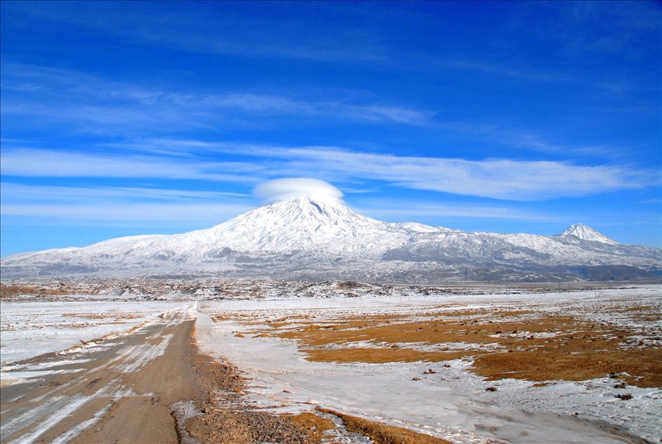
Mount Ağrı is situated within the boundaries of Ağrı Province, near Iğdır and surrounding districts, at coordinates 38° 44' 00" North latitude and 44° 18' 00" East longitude. This mountain massif rises over a broad base of approximately 1,200 km² and has a perimeter of about 130 km. The mountain features two distinct conical peaks: Greater Ağrı (5,137 m) and Lesser Ağrı (3,896 m). These two cones are connected by the Serdarbulak Saddle at an elevation of 2,700 meters. This feature demonstrates that Mount Ağrı is not a single summit but a vast system composed of two interlinked volcanic cones.
The areas above 4,000 meters are covered with snow throughout the year. The glacier covering approximately 12 km² at the summit is the largest of the few glaciers found in Türkiye. These glaciers, located within the boundaries of Mount Ağrı National Park, are among the key elements shaping the mountain’s physical appearance.

Mount Ağrı (Anadolu Agency)
Mount Ağrı has a volcanic origin and is primarily composed of andesite and basalt lava flows. Its formation dates back to the Miocene Epoch, approximately 25 million years ago. Volcanic activity during this period shaped the mountain through successive lava flows, resulting in a layered volcanic structure. The summit and upper elevations exhibit dense accumulations of volcanic rocks, lava strata, and vesicular (porous) lavas. Over time, these hardened lavas formed the foundation of the mountain’s current mass. Smaller volcanic elevations surrounding the mountain reflect the regional impact of its historical volcanic activity. Additionally, some of the rocks in the area show evidence of metamorphic processes.
Mount Ağrı has a high mountain climate. Temperatures near the summit can drop to as low as -20°C during winter months. Even in summer, temperatures remain low around the peak. The lower slopes experience a milder climate, where vegetation is more dense. The higher elevations are largely treeless; today, the mountain is mostly devoid of forests. However, some areas feature juniper shrubs and dwarf birch trees. Lower elevations contain stands of oak, pine, and cedar. As altitude increases, vegetation becomes sparse, giving way to alpine meadows and various succulent species. The flora of Mount Ağrı National Park includes 21 endemic plant species. Fauna in the region includes the wild goat, roe deer, bear, and wild boar. Among the mountain’s significant species are the endemic and endangered Süphan lizard and the Apollo butterfly.【1】
The historical and cultural significance of Mount Ağrı extends beyond its geographical features. The mountain has been regarded as sacred in Near Eastern cultures for centuries. The most well-known narrative relates to the Story of Noah’s Flood. In Islamic, Christian, and Jewish traditions, there is a widespread belief that Noah’s Ark came to rest on Mount Ağrı after the flood.【2】
Mount Ağrı has been known by various names across different cultures: in Yakut, “Ağr”; during the Seljuk period, “Eğri Dağ” or “Ağır Dağ”; in Persian sources, “Kûh-ı Nûh”; in Arabic sources, “Cebelülhâris” for Greater Ağrı and “Cebelülhuveyris” for Lesser Ağrı; and by Armenians as “Massis” or “Masik”. The Western geographical term “Ararat” derives from the biblical phrase “Mountains of Ararat”. The term Ararat is historically linked to the Urartu Kingdom. The name Urartu, originating from the Assyrian “Uruatri”, was mispronounced in Hebrew texts as “Ararat”. This designation originally referred to the mountainous region southeast of Lake Van. Therefore, the direct identification of the “Mountains of Ararat” mentioned in the Hebrew Bible with today’s Mount Ağrı is not definitively supported by historical sources. Babylonian, Syriac, and other regional traditions describe the location of Noah’s Ark differently.【3】
The strategic location and mythological importance of Mount Ağrı have attracted numerous researchers and climbers since the 18th and 19th centuries. The first scientifically documented ascent was made in 1829 by Friedrich Parrot, who reached the summit and described a flat area believed by some to be the remains of Noah’s Ark. In the 19th century, other climbers such as Antonomoff (1834, 1843), Wagner and Abich (1845), Albay Chodsko (1850), and Stuart and Monteith (1856) also ascended the mountain. In 1876, James Bryce claimed to have seen a carved wooden fragment among lava deposits at around 4,000 meters. In 1893, Dr. Nuri, the Patriarch of Jerusalem, asserted that the middle section of the ark was buried under ice. However, none of these claims are supported by scientific evidence. In the 20th century, claims continued; structures reportedly seen by Russian and Soviet pilots from the air became subjects of various investigations. In 1937, a Turkish expedition led by Lieutenant Colonel Cevdet Sunay reached the summit and conducted surveys but found no remnants. Another expedition in 1968 under Colonel Turhan Selçuk reached similar conclusions. More recently, claims by American astronaut James Irwin also lack concrete evidence.【4】
Mount Ağrı and its immediate surroundings were declared Mount Ağrı National Park in 2004. The park encompasses the districts of Doğubayazıt in Ağrı and Aralık and Karakoyunlu in Iğdır. This area consists of three main sections: Greater Ağrı and Lesser Ağrı mountains, a meteor crater, and areas claimed to be the resting place of Noah’s Ark.
Numerous outdoor activities are practiced in this region, including mountaineering, hiking, camping, paragliding, photography, and angling. Climbing the mountain is typically undertaken during summer months, with July and August preferred due to favorable weather conditions. The ascent to the summit generally takes 4 to 6 days and is recommended to be done with a guide. Infrastructure such as camping areas and mountain huts is available around Doğubayazıt.

Mount Ağrı National Park (Ağrı Provincial Directorate of Culture and Tourism)
Mount Ağrı provides economic resources for the local population primarily through tourism activities. Mountaineering and nature tourism generate income for local businesses and the service sector.
Anadolu Ajansı. “Ağrı Dağı.” Anadolu Ajansı. Accessed December 9, 2025.https://www.aa.com.tr/tr/pg/foto-galeri/agri-dagi/0
Ağrı İl Kültür ve Turizm Müdürlüğü. "Ağrı Dağı Milli Parkı." T.C. Kültür ve Turizm Bakanlığı. Accessed December 9, 2025.
Ağrı İl Kültür ve Turizm Müdürlüğü. "Ağrı Dağı." T.C. Kültür ve Turizm Bakanlığı. Accessed December 9, 2025.
Kültür Portalı. "Ağrı Dağı-Ağrı." Türkiye Kültür Portalı. Accessed December 9, 2025.https://www.kulturportali.gov.tr/turkiye/agri/gezilecekyer/agri-dagi
Tanyu, Hikmet. “Ağrı Dağı.” *Türkiye Diyanet Vakfı İslâm Ansiklopedisi*, vol. 1, İstanbul, 1988, pp. 481–482. Accessed December 9, 2025.https://islamansiklopedisi.org.tr/agri-dagi
[1]
Kültür Portalı, “Ağrı Dağı-Ağrı,” Türkiye Kültür Portalı, Erişim tarihi: 9 Aralık 2025. https://www.kulturportali.gov.tr/turkiye/agri/gezilecekyer/agri-dagi
[2]
Hikmet Tanyu, “Ağrı Dağı,” Türkiye Diyanet Vakfı İslâm Ansiklopedisi, Erişim tarihi: 9 Aralık 2025. https://islamansiklopedisi.org.tr/agri-dagi
[3]
Hikmet Tanyu, “Ağrı Dağı,” Türkiye Diyanet Vakfı İslâm Ansiklopedisi, Erişim tarihi: 9 Aralık 2025. https://islamansiklopedisi.org.tr/agri-dagi
[4]
Hikmet Tanyu, “Ağrı Dağı,” Türkiye Diyanet Vakfı İslâm Ansiklopedisi, Erişim tarihi: 9 Aralık 2025. https://islamansiklopedisi.org.tr/agri-dagi

Location | Ağrı Province 16 kilometers west of Iran and 32 kilometers south of Armenia | ||||||||
|---|---|---|---|---|---|---|---|---|---|
Elevation | 5,137 meters (Türkiye's highest peak) | ||||||||
Geological Type | Volcanic, approximately 25 million years ago | ||||||||
Geographical Features
Geological Structure and Volcanic Origin
Climate, Vegetation, and Ecosystem
Historical and Mythological Context
Research and Climbing History of Mount Ağrı
Current Use of the Mountain and Its Surroundings
Social and Economic Impacts