This article was automatically translated from the original Turkish version.
+2 More
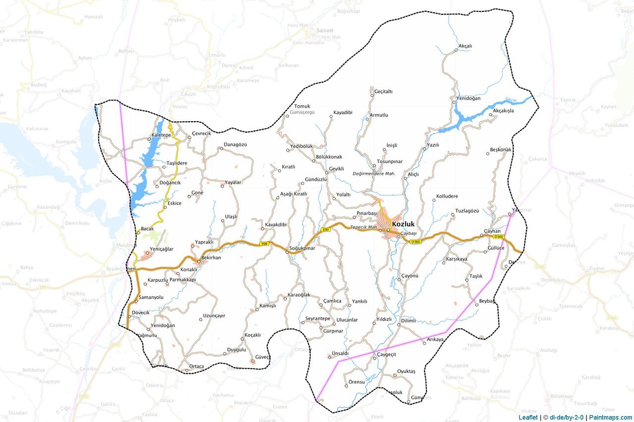
Kozluk is a district affiliated with Batman. Formerly known as Hazo, Kozluk is located on the northern frontier of Mesopotamia, within the east section of Anatolia, at place. Its history extends back to the Neolithic period and due to its strategic location it has been inhabited by various civilizations. It has an area of 1,101 km² and a population of 61,100. The district includes one township (Bekirhan), 30 neighborhood, 69 village, and 115 hamlets.
Pre-Islamic Period: The upper Tigris valley where Kozluk is situated has been home to settlements since the Neolithic, Chalcolithic, and Bronze Ages. Excavations conducted in 1990 at the Hallan Çemi mound in Kaletepe village uncovered female ornaments, animal figurines, and stone weapons dating back approximately 12,000 years. These findings demonstrate that the region predates Çayönü as a settlement site. Throughout history, Kozluk has been inhabited by the Subarians, Hurrians, Sumerians, Akkadians, Assyrians, Babylonians, Urartians, Medes, Persians, Macedonians, Seleucids, Sassanids, Romans, and Byzantines. In the 10th century BCE, the Assyrians waged war against the Khasi tribe in the Hazo mountains and captured the fortress of Nishtun.
Early Islamic Period: Kozluk was conquered by Iyad ibn Ghanem during the time of Hz. Omar (AH 18/639) and incorporated into Islamic territories. It was subsequently governed by the Umayyads, Abbasids, Hamdanids, Marwanids, Seljuks, Dilmaçoğulları, Artuqids, Ayyubids, Kara Koyunlu, Akkoyunlu, and Safavids. During the Seljuk period (after 1085), the Hazo-Sason fortresses came under Seljuk control. The Ayyubids established dominance in the region during the 13th century, followed by the Akkoyunlus in the 15th century. Under pressure from the Safavids, the Ottomans, through the efforts of Idris-i Bitlisi, gained control of the region in 1515–1516.
Ottoman Period: During the Ottoman era, Kozluk was administered as the Sason-Hazo beylik. According to the Şerefname, the beylik’s origins trace back to the brothers İzzeddin and Ziyaeddin. In the 16th century, it was governed as a liva subordinate to the Diyarbekir Eyalet, with government status during time times. Evliya Çelebi described Hazo in 1655 as a castle and town. In the 19th century, Hazo, a township under the Siirt sanjak, had a population of 10,000. According to Vital Cünet, half the population was Muslim and the other half consisted of Armenian Gregorians and Catholics.
Republican Period: In the early years of the Republic, Hazo was initially attached to Muş, then became a subdistrict of Sason. In 1938, it attained district status under Siirt and adopted the name Kozluk. In 1990, with Batman’s elevation to provincial status, Kozluk became affiliated with Batman. Tobacco cultivation and leaf enterprises spurred economic growth, but due to tobacco quotas and security issues, significant migration to large cities occurred. Investments in Infrastructure have positioned the district favorably for economic development.
Kozluk is located in the Southeastern Anatolia Region, on the northern frontier of Mesopotamia. It is 59 km from the center of Batman and 132 km from Diyarbakır. It lies between 41°10’ and 41°41’ east longitude and 38°40’ and 37°50’ north latitude, at an elevation of 750 meters. Its area is 1,101 km². Thirty percent of its terrain is mountainous, 45 percent is plain, 15 percent is pastureland, and 10 percent is undulating. Its main mountains are Avcı, Crown, Aşit, Meydanoktepe, and Çikalotepe. The northern boundary is surrounded by steep mountains, while the southern part slopes toward the Tigris valley and the Batman River bed. The northern, eastern, and western boundaries of the district are encircled by rivers, giving it a peninsula-like appearance.
A continental climate prevails in Kozluk. The coldest months are January to February, and the hottest are July to August Türkiye. Soil is fertile and suitable for agriculture and animal husbandry. Major crops include tobacco, wheat, barley, lentils, and cotton. Kozluk tomato, grown in villages such as Gümüşörgü and Yedibölük, is a thin-skinned, juicy variety. Highland areas feature pastures and cold springs. Plant cover consists of agricultural land in plains and pastures, and sparse forests and grazing areas in mountainous regions.
The population of Kozluk largely descends from communities that migrated from Basra during the Umayyad or Abbasid periods. The majority speak Arabic, although some have been assimilated. Kurdish elements such as the Rojkan tribe are also present. Evliya Çelebi described the population as adhering to the Shafi’i school of thought. Migration to west provinces began after 1933, and in recent years economic and security issues have intensified emigration. Family ties are strong and social solidarity is widespread.
The economy of Kozluk is based on agriculture and animal husbandry. Major agricultural products include tobacco, wheat, lentils, cotton, tomatoes, cereals, vegetables, and fruits. Rock salt production in the villages of Tuzlagözü and Derince is used in pickling, cheese-making, and pickling. Rock salt is extracted from wells during spring months using evaporation methods. Livestock farming, both large and small animal husbandry, and sweet water fishing are common. Oil exploration in the Şelmo region, textile workshops, and industries producing soil, concrete, brick, and pumice provide employment. The Small Industrial Zone has increased commercial activity. Kozluk lies along the Türkiye-Iran route.
Malabadi Bridge, built during the Artuqid period (1147), is one of the world’s widest stone-arched bridges with a span of 38.6 meters and is listed on UNESCO’s Tentative World Heritage List. Kozluk Castle, İbrahim Bey Mosque, and Hızır Bey Mosque (1512) are among its historical structures. The Hallan Çemi Mound carries an archaeological heritage spanning 10,000 years. Taşlıdere Hot Springs are developing for thermal tourism. The healing spring in Halile village, the fish-filled lake in Oyuktaş Yeşilyurt, the Ayngebire (Tosunpınar) area, and the Garzan-Cefan Reservoir are natural sites. The Malabadi Nature Park and the forest park project support tourism.
Kozluk has a population of 61,100 (population density: 55 people per km²). Approximately 30,000 live in the center, with a total of 65,000 close residents. The majority are Muslim; Armenian Gregorians and Catholics were present in the past. Population growth was supported by tobacco farming, but migration has occurred due to quotas and security concerns. People is of Arab and Kurdish origin. It shares cultural and demographic similarities with Sason.
Dicle Kalkınma Ajansı. "Yerleşik Yaşamın Başladığı Nokta: Kozluk." Accessed April 19, 2025. https://www.dika.org.tr/batman/ilceler/yerlesik-yasamin-basladigi-nokta-kozluk.
Kozluk Kaymakamlığı. "Coğrafya." Accessed April 19, 2025. http://www.kozluk.gov.tr/cografya.
Kozluk Kaymakamlığı. "Kaya Tuzu." Accessed April 19, 2025. http://www.kozluk.gov.tr/kaya-tuzu.
Kozluk Kaymakamlığı. "Kozluk Domatesi." Accessed April 19, 2025. http://www.kozluk.gov.tr/kozluk-domatesi.
Kozluk Kaymakamlığı. "Malabadi Köprüsü." Accessed April 19, 2025. http://www.kozluk.gov.tr/malabadi-koprusu.
Kozluk Kaymakamlığı. “Kozluk Tarihçesi.” Accessed April 19, 2025. http://kozluk.gov.tr/kozluk-tarihcesi.
History
Geographical Structure
Climate and Vegetation
Social Structure
Economic Structure
Tourism
Demographic Structure