


This article was automatically translated from the original Turkish version.
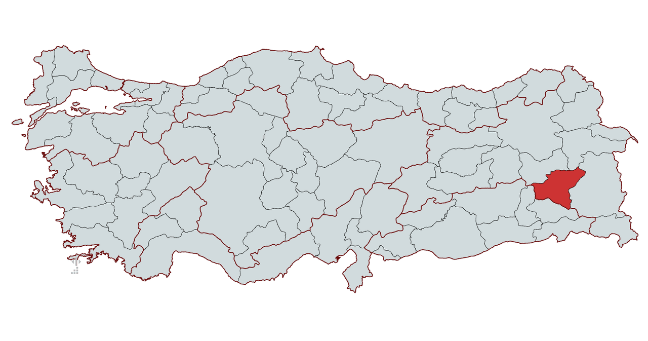
Bitlis
Country | Türkiye | ||||||||
|---|---|---|---|---|---|---|---|---|---|
Area | 8.294 km² | ||||||||
Population | 359.80 | ||||||||
Districts | Adilcevaz Ahlat Güroymak Hizan Mutki Tatvan | ||||||||
Climate | Continental climate | ||||||||
License Plate | 13 | ||||||||
Area Code(s) | 434 | ||||||||
Mayor | Nesrullah TANĞLAY | ||||||||
Governor | Ahmet KARAKAYA | ||||||||
Important Structure | Ahlat Museum Bitlis Castle Ahlat Seljuk Tombs Nemrut Lake Nazik Lake İhlasiye Medresesi El-Aman Hanı | ||||||||
Bitlis is a city in the Eastern Anatolia Region of Türkiye, known for its historical and cultural richness. It is bordered by Van to the east, Muş to the west, Ağrı to the north, and Siirt to the south. Due to its strategic location, Bitlis has served as a home to numerous civilizations throughout history. Its position along the Silk Road route transformed the region into a significant center for trade and cultural exchange. Today, Bitlis attracts attention through its historical structures, natural beauty, and rich culinary culture.【1】

Bitlis (Murat Marangoz, pexels.com)
There are various etymological theories regarding the origin of the name Bitlis. Throughout its historical development, the city’s name has appeared in different forms across multiple languages. In Arabic sources, it is recorded as Badlîs, while in Armenian it appears as Bağağéş, and in local dialects likely as Aramaic or Assyrian Balalêş. This suggests that the name Bitlis may be linked to ancient languages and reflects the region’s exposure to diverse cultures since prehistoric times.【2】
According to a widely held folk tradition, the name Bitlis is attributed to one of Alexander the Great’s commanders. However, this narrative is considered legendary and lacks historical foundation. The more plausible etymological origin lies in the ancient languages of the region. In this context, the historical evolution of the name Bitlis is closely tied to the region’s cultural diversity and multilingual character.
The history of Bitlis extends back to the Urartian period. In the 9th century BCE, the Kingdom of Urartu established dominance over Lake Van and its surroundings, becoming the region’s first major political power. With the decline of the Urartians, the region came successively under the control of the Medes, Persians, the Kingdom of Macedonia, and later the Roman-Byzantine Empire. During the Persian Empire, Bitlis was administered within the satrapy system and gained importance as a key location along east-west trade routes. In the 4th century BCE, Alexander the Great’s conquest of Persia brought the region under Hellenistic influence. However, after Alexander’s death, the area changed hands frequently among the Hellenistic successor states. Under Roman-Byzantine rule, Bitlis and its surroundings became a frontier zone of strategic importance, repeatedly contested during the Sassanian-Byzantine conflicts and serving as a military and commercial hub.
With the Islamic armies’ entry into Anatolia in the 7th century, Bitlis came under the rule of the Umayyads and Abbasids. During this period, the region frequently changed hands between Byzantine and Muslim forces. In the 11th century, with the Seljuk Turks’ arrival in Anatolia, Bitlis came under Seljuk control. During this era, the region was entrusted to local Kurdish beyliks, which preserved their autonomy and continued to govern until the Ottoman period.
Bitlis became part of the Ottoman territories following the Battle of Chaldiran in 1514. While contesting the Safavids, the Ottomans collaborated with local Kurdish beyliks and entrusted the administration of Bitlis to the Şerefhan Beylik. One of its most prominent rulers, Şeref Han, detailed the region’s political structure in his 16th-century work, Şerefname.
Throughout the 17th century, the Ottoman central administration sought to establish direct control over Bitlis, but this process was fraught with difficulties due to resistance from local beyliks. In the 19th century, the Ottoman central government implemented administrative reforms to weaken local authorities. Following the Tanzimat Decree, Bitlis was formally incorporated into the Ottoman provincial system. In 1879, the Bitlis Vilayet was established, and the city became a major center along the eastern frontier of the Ottoman Empire.
During World War I, Bitlis became a battleground between Ottoman and Russian forces. In 1916, Russian troops occupied Bitlis, but after the Bolshevik Revolution of 1917, Russian forces withdrew, and Ottoman troops regained control of the city. However, during the war, Bitlis suffered extensive destruction, and a large portion of its population was forced to migrate.

Bitlis in the early 20th century (Photograph: TDV Islamic Encyclopedia)
Bitlis continued as a province of the Republic of Türkiye after its founding in 1923. Having suffered population losses due to wars and migrations during the Ottoman era, the city underwent economic and social reorganization in the early years of the Republic.
Throughout the Republican period, Bitlis remained a city centered on intensive agriculture and animal husbandry. Due to security issues in the region after 1980, the city experienced significant emigration. Beginning in the 2000s, however, efforts focused on tourism and cultural activities revitalized the city. Today, Bitlis maintains its status as one of the important provinces of Eastern Anatolia through its historical structures, natural beauty, and cultural heritage.
Bitlis is one of the provinces of Türkiye’s Eastern Anatolia Region, situated between 36° 30' and 38° 30' north latitudes and 41° 33' and 43° 11' east longitudes. The province covers an area of approximately 8,294 km². It is bordered by Van to the east, Muş to the west, Ağrı to the north, and Siirt and Batman to the south.
The western boundary with Muş is defined by the Murat River, while the eastern boundary with Van is marked by the shores of Mount Nemrut and Lake Van. The southern part of the province, surrounded by Siirt and Batman, features predominantly mountainous and rugged terrain. The most significant geographical features of Bitlis are Mount Süphan in the north and Nemrut Lake in the east.
Due to its location within the Lake Van Basin, Bitlis possesses significant water resources. The northwestern shores of Nemrut Crater Lake and Lake Van form the natural boundaries of the province. Additionally, high-altitude mountains and plateaus dominate the western and southern regions, where a harsh continental climate prevails throughout the province.
Bitlis experiences a continental climate. Due to its location in Eastern Anatolia, summers are short and cool, while winters are long, severe, and characterized by heavy snowfall. Its topography, with elevations exceeding 1,500 meters above sea level, contributes to pronounced temperature variations.
Winter temperatures in Bitlis frequently range between -15°C and -20°C, with heavy snowfall common. Snow typically begins in November and can remain on the ground until April. Summer temperatures range between 20°C and 30°C, though nights remain cool. The proximity of Nemrut Lake and Lake Van slightly moderates the climate in the eastern part of the province.
Bitlis’s vegetation, shaped by high altitude and harsh climatic conditions, consists primarily of steppe and forested areas. High mountain meadows and alpine flora are common in the northern and eastern regions. In the western and southern areas, oak and juniper forests are prominent. Particularly near the Muş border and around Mount Nemrut, forested areas constitute vital ecosystems preserving the region’s natural structure. However, in high-altitude zones, alpine meadows dominate, and agricultural activity is limited. Agricultural lands are concentrated mainly in valley floors and near lake shores.
Bitlis’s vegetation is a combination of high-altitude forests, alpine meadows, and steppe. However, overgrazing and human activity have caused degradation in some areas.
Bitlis is a province characterized by mountainous and rugged terrain in Eastern Anatolia. With an average elevation ranging between 1,500 and 2,500 meters, its geography is shaped largely by volcanic mountains, plateaus, highlands, and rivers. The majority of the province’s land is uneven, and settlements are concentrated primarily in valley floors and along lake shores.
One of Bitlis’s most prominent natural features is its high mountains. Mount Süphan (4,058 m), Türkiye’s third-highest peak, lies in the northeastern part of the province and forms a natural boundary with Van. In addition, the volcanic Mount Nemrut (2,948 m) and its surrounding crater lake significantly contribute to the province’s geographical character. In the southern region, Mount Ziyaret (2,531 m) and surrounding high peaks are notable. Due to this mountainous structure, extensive flatlands are very limited in Bitlis.

Mount Süphan (Photograph: Havle Kaya, unsplash.com)
Although the province lacks extensive agricultural plains, the Bitlis Plain and Ahlat Plain are important agricultural areas. The Bitlis Plain, located near the provincial center, is surrounded by mountains. The larger Ahlat Plain, situated along the shores of Lake Van, contains some of the most fertile soils in the province. Much of the province is covered by highland meadows and plateaus. One of the most important meadows, Rahva Meadow, located along the Bitlis-Tatvan road, features extensive pastures. Hizan and Ahlat meadows are particularly significant for small livestock farming.
Bitlis is rich in river systems. The Murat River, one of the province’s most important water sources, flows from the western boundary into the Euphrates River. The Bitlis Creek flows through the provincial center and empties into Lake Van, sustaining local settlements. The Karasu Creek passes through the districts of Ahlat and Adilcevaz before reaching the lake.
Lakes are among Bitlis’s most important water resources. Lake Van, Türkiye’s largest lake, lies along the province’s eastern border, with the districts of Tatvan, Ahlat, and Adilcevaz situated on its shores. Nemrut Lake, a volcanic lake located at the summit of Mount Nemrut, is a significant ecosystem renowned for its natural beauty. Nazik Lake, a freshwater lake within the boundaries of Adilcevaz district, supports fishing activities in its vicinity. These lakes are vital components supporting Bitlis’s water resources and natural diversity.
Bitlis province, with its rich natural structure and diverse ecosystems, provides habitat for numerous species of wild animals and birds. Mountains, lakes, forested areas, and wetlands form the habitats of these species. Notably, the Adilcevaz Süphan Mountain Wildlife Development Area (WDA), covering approximately 30,000 hectares, serves as a habitat for wild goats, bezoar goats, various raptors, and eagles. This area was designated for wildlife conservation on 16 October 2005.
Due to its strategic location along bird migration routes, Bitlis hosts approximately 300 different bird species. Wetland areas in the Lake Van Basin, including Nemrut Lake and the Iron Marsh, provide valuable habitats for both migratory and resident waterfowl. Numerous species, including raptors, fish-eaters, songbirds, and waterfowl, can be observed in these areas.
Heybeli Lake is a significant site for avian diversity. A study conducted between March 2017 and April 2018 identified 78 bird species belonging to 32 families and 14 orders. Of these, 34 were resident, 35 were summer visitors, 5 were winter visitors, and 4 were transients. Additionally, threatened species such as the White-headed Duck (Oxyura leucocephala) are also found in this region.
Bitlis province is located in eastern Türkiye and, as of 2024, has a total population of 359,808. Of this population, 50.2% are male and 49.8% are female. Bitlis has a youthful demographic profile: 30.2% of the population is aged 0–14, 64.1% is of working age (15–64), and 5.7% is aged 65 and over.
In education, the literacy rate in Bitlis is 91.5%, with 95.2% among men and 87.8% among women. The proportion of primary school graduates is 35.4%, those with middle school or equivalent education is 22.7%, those with high school or equivalent education is 18.9%, and those with higher education is 7.3%.
The average household size in Bitlis is 5.2 persons, above the national average. There are 69,174 households in the province. Of these, 12.3% are single-person households, 15.8% are single-parent households, 67.4% are nuclear families, and 4.5% are extended families.
The total fertility rate in Bitlis is 2.7 children per woman, higher than the national average of 1.88. The crude birth rate is recorded at 14.3 per 1,000 population. According to labor force data, the labor force participation rate is 48.1%, with 68.4% among men and 27.8% among women. The unemployment rate is 9.7% overall.
Adilcevaz: 29,290
Ahlat: 45,096
Güroymak: 46,090
Hizan: 31,030
Mutki: 27,872
Tatvan: 103,752
The economy of Bitlis province is primarily based on agriculture, animal husbandry, and handicrafts. Industrial and commercial activities are limited, but local production and traditional handicrafts hold significant importance in the provincial economy.
Bitlis’s geography and climate shape its agricultural and animal husbandry activities. The majority of the province’s area is mountainous and rugged, limiting arable land. Nevertheless, extensive agricultural areas exist in the districts of Ahlat and Adilcevaz, where wheat, barley, sugar beet, and potatoes are cultivated. Additionally, thanks to the microclimate along the shores of Lake Van, fruit cultivation, particularly walnuts and apricots, is practiced.
Animal husbandry is a cornerstone of Bitlis’s economy. The province’s mountainous and highland pastures provide suitable grazing areas for both small and large livestock. Sheep and goat farming are widespread, with milk and meat products used for both local consumption and commercial sale. Beekeeping is also significant in the province, producing high-quality honey.
Industrial activity in Bitlis is limited. Although large-scale industrial facilities are absent, small and medium-sized enterprises contribute to the local economy. Businesses in food processing, textiles, and construction materials are relatively more numerous. However, industrial development is constrained by infrastructure deficiencies and transportation challenges.
Commercial activity is primarily oriented toward local markets. Agricultural and animal husbandry products produced in the province are sold locally and also exported to neighboring provinces. Additionally, Bitlis’s traditional handicrafts meet local needs and are in demand as tourist souvenirs. Notably, Ahlat walking sticks, handwoven kilims and carpets, ceramic products, and regional clothing are important commercial items reflecting the province’s cultural heritage.
The Eastern Anatolia Project (EAP) is a comprehensive initiative aimed at accelerating development in Eastern Anatolia. Bitlis is one of the 15 provinces included in the EAP and possesses significant potential in agriculture and animal husbandry. The EAP Regional Development Administration supports agricultural production in Bitlis and promotes the adoption of modern farming techniques.
In the district of Ahlat, with EAP support, apple cultivation is carried out on 3,000 decares, targeting a total yield of 2,000 tons. Ahlat apples are among the region’s key agricultural products and are in demand in the domestic market.
Additionally, in Tatvan district, Bitlis has implemented the “EAP with Agriculture 4.0 Early Warning Systems” and “EAP with the Future of Agriculture: Drones” projects. These initiatives enhance agricultural productivity and promote environmentally friendly practices. Early warning systems enable effective combat against crop diseases and pests, while drones facilitate controlled and efficient application of pesticides and fertilizers.
Bitlis, with its deep historical roots and cultural heritage, hosts numerous traditional handicrafts. The province’s geography, climate, and historical exposure to diverse civilizations have contributed to the diversity of these crafts. Today, traditional handicrafts remain vital elements of Bitlis’s cultural identity.
One of Bitlis’s most famous handicrafts is the production of Ahlat walking sticks. These sticks are crafted from specially selected walnut, cherry, and mulberry wood, requiring skilled craftsmanship and intricate detailing. The shafts are commonly engraved with motifs of dragons, snakes, lions, and eagles. Due to their handmade nature and fine workmanship, Bitlis walking sticks are regarded as an important cultural value of the region.

Ahlat walking stick (Photograph: Serdar Adıyaman, Anadolu Agency)
Kilim weaving in Bitlis is a longstanding craft passed down through generations. Local kilims are typically woven with wool thread and dyed using plant-based pigments. Traditional kilim motifs frequently depict nature, animal figures, and geometric patterns. Bitlis and surrounding kilims are known for their durability and color quality. Handwoven carpets produced on looms are often considered part of a bride’s dowry.
Goat hair weaving is a widespread handicraft in rural areas of Bitlis. Woolen felt products are produced in regions with high livestock density and are used primarily for shepherd’s cloaks, hats, and floor coverings. Felt products are manufactured to suit cold climates due to their waterproof and durable properties.
Harik, a traditional handmade shoe, is among Bitlis’s traditional handicrafts and an important part of its cultural heritage. This footwear, produced for centuries using only natural materials, is known for its durability. Hariks are carefully crafted by artisans in Bitlis and its surroundings and are traditionally worn with local attire.

Harik (Photograph: Şener Toktaş, Anadolu Agency)
Wood carving holds an important place in Bitlis. The art of wooden decoration, seen in historical structures such as mosques, medrese, and türbe, has been preserved from antiquity to the present. Wood carving is commonly used in furniture, chests, and door decorations. Another longstanding craft in Bitlis is copperwork. Copper vessels, coffee pots, and decorative items are produced using traditional hammering and engraving methods.
The Ahlat Seljuk Cemetery, located in the district of Ahlat, is an important cultural heritage site listed on UNESCO’s Tentative World Heritage List. Dating from the 12th and 13th centuries, the cemetery features large stone sarcophagi, stelae, and monumental tombstones. This site, containing some of the most important examples of Turkic-Islamic tombstones, demonstrates Ahlat’s historical significance as a major center.

Ahlat Seljuk Tombs (Photograph: Turkish Museums)
One of the city’s most important historical structures, Bitlis Castle is traditionally believed to have been built by one of Alexander the Great’s commanders in the 4th century BCE. Built atop a high rock, the castle secured a strategic position. It remained an important defensive point during the Ottoman period and is now open to visitors.

Bitlis Castle (Photograph: TDV Islamic Encyclopedia)
One of Bitlis’s most important natural attractions, Nemrut Lake is the world’s second-largest and Türkiye’s largest crater lake. Located on Mount Nemrut, the lake is divided into warm and cold sections. Thermal springs are present, offering opportunities for nature walks and camping for visitors.

Nemrut Lake (Photograph: Şener Toktaş, Anadolu Agency)
The El Aman Han, built in the 16th century during the Ottoman period, is a significant caravanserai located along the Silk Road route. It is one of the finest examples of Ottoman architecture and has been restored for tourism purposes.
One of the most important structures from the Seljuk period, the İhlasiye Medrese is located in the center of Bitlis city. Built in the 13th century, it is notable for its stonework and decorative details. Previously used as a center for science and education, it is now open to visitors.

İhlasiye Medrese (Photograph: TDV Islamic Encyclopedia)
The Şerefiye Mosque, built in the 16th century, is an Ottoman-era structure reflecting classical Ottoman architectural elements. Notable for its stonework and spacious interior, the mosque remains active for worship and is among Bitlis’s important religious buildings.
Located to the east of Bitlis, Lake Van is one of the province’s main tourist attractions. The district of Adilcevaz lies along the lake’s shore, offering relaxation and water sports opportunities with scenic views. The shoreline is also an important center for fishing and water tourism.
Bitlis has numerous historic bridges from the Ottoman and Seljuk periods. Structures such as the Ahlat Emir Bayındır Bridge, Hizan Bridge, and Mutki Arched Bridge served as vital transportation nodes along ancient trade routes. Today, these bridges are preserved in their historical form and remain open to visitors.
The Ahlat Museum, located in the district of Ahlat, is one of the most important museums showcasing the region’s rich historical and cultural heritage. Established in 1970, the museum displays artifacts from the Urartian, Roman, Byzantine, Seljuk, and Ottoman periods.
The museum houses an extensive collection of archaeological, ethnographic, and numismatic items. Particularly, inscriptions excavated from the Ahlat Seljuk Tombs are among the most important examples of Seljuk stone craftsmanship. Additionally, traditional Ahlat handicrafts, weapons, kitchen utensils, and regional clothing are exhibited.

Ahlat Museum (Photograph: Turkish Museums)
Bitlis cuisine consists of traditional flavors reflecting the rich and unique culinary culture of Eastern Anatolia. Dishes centered on meat and grains, along with regional spices and cooking methods, distinguish Bitlis cuisine.
One of the most famous dishes of Bitlis cuisine is Büryan Kebab. Goat or lamb meat is slowly roasted over wood fires in special pits. This dish, traditionally consumed in the morning, has survived as a local custom to the present day.
In Bitlis, stuffed meatballs are called Kitel. A dough made from bulgur and meat encloses a filling of minced meat, onion, and spices. Boiled and served as a dish, Kitel is an indispensable part of Bitlis dining tables.
Keledoş is a legume dish unique to Bitlis cuisine. Made with green lentils, chickpeas, çökelek, wheat, and bone-in meat, it is seasoned with yogurt and butter. Keledoş, commonly prepared in winter, is a nutritious and filling dish.
One of Bitlis’s popular stuffed dishes is Katıklı Dolma. The interior of a pumpkin is filled with minced meat, bulgur, rice, and spices, then served with yogurt. This dish is commonly featured on guest tables.
Bitlis province has historically been an important center of education. Islamic sciences taught in madrasas played a central role in the city’s educational life. Today, Bitlis continues to develop in the field of education.
The province has numerous primary, middle, and high schools under the authority of the Ministry of National Education. Vocational and technical education institutions are also present. In higher education, Bitlis Eren University serves students through various faculties and colleges.
To ensure equal educational opportunities, a mobile education system operates in rural areas, providing various supports to students. Additionally, adult education centers offer courses to promote professional and personal development.
Bitlis has important road connections in east-west and north-south directions. The D300 highway links the province to Van in the east and Muş and Elazığ in the west, while the D955 highway connects to Ağrı in the north and Siirt in the south. These roads facilitate access to other regions and play a critical role in commercial activity.
Tatvan district in Bitlis is a key node in rail transport. The Tatvan Ferry Terminal provides rail connections across Lake Van to Van and further to Iran. This route holds strategic importance for international freight and passenger transport.
The nearest airport to Bitlis provincial center is the Muş Sultan Alparslan Airport, located approximately 30 km away. This airport offers regular domestic flights to major cities such as Istanbul and Ankara. Additionally, the Van Ferit Melen Airport, approximately 100 km away, serves as an alternative for national and international flights.
In recent years, various improvements have been made to Bitlis’s infrastructure. Expansion and maintenance of the road network have enhanced safety and comfort in transportation. New bridge and tunnel projects have been implemented to improve access to rural settlements. The province’s energy infrastructure has been strengthened, with electricity and natural gas services extended to a wide area. Modernization of water and sewage networks aims to improve residents’ quality of life.
The current governor of Bitlis is Ahmet KARAKAYA, appointed by Presidential Decree No. 2024/321 dated 18 September 2024 and published in the Official Gazette No. 32667 on 19 September 2024.
Abdurrezzak, Bakış. Ercan, Işık. "Bitlis Ulaşım Analizi ve Ulaşım Sorunları Çözüm Önerileri." BEÜ Fen Bilimleri Dergisi 1, no. 1 (2012): 19-33.
Bitlis Kültür and Tourism Provincial Directorate. "Camii ve Kümbetler." Accessed February 19, 2025.https://bitlis.ktb.gov.tr/TR-56226/camii-ve-kumbetler.html
Bitlis Tarım of Agriculture and Forestry. "İlimiz Hakkında Genel Bilgiler." Ministry of Agriculture and Forestry of the Republic of Turkey. Accessed February 19, 2025.https://bitlis.tarimorman.gov.tr/Menu/17/Ilimiz-Hakkinda-Genel-Bilgiler
Havle, Kaya. Mount Süphan, Yıldızköy/Adilcevaz/Bitlis, Turkey [JPG]. Accessedhttps://unsplash.com/photos/a-snowy-mountain-range-j56XC3TJuzM.
Metin, Tuncel. “Bitlis.” TDV İslam Ansiklopedisi. Accessed February 19, 2025.
Nişanyan Yeradları. "Bitlis." Nişanyan Yeradları Türkiye ve Çevre Ülkeler Yerleşim Birimleri Envanteri. Accessed February 19, 2025.https://www.nisanyanyeradlari.com/?y=Bitlis&ul=Hepsi&o=c&s=1&n=0
PHOTOGRAPHS
RESEARCH WORKS
Serdar, Adıyaman. Bitlisli usta 24 Oğuz boyuna ait tamgaları Ahlat bastonuna işliyor [JPG]. Anadolu Ajansı. Accessed [CITATION_LINK_0].
T.C. Bitlis Valiliği. "Bitlis Tarihçesi ve Genel Bakış." Accessed February 19, 2025.http://www.bitlis.gov.tr/bitlis-tarihcesi-ve-genel-bakis
T.C. Bitlis Valiliği. "BİTLİS VALİSİ AHMET KARAKAYA." Accessed February 19, 2025.http://www.bitlis.gov.tr/sayin-valimiz
T.C. Bitlis Valiliği. "El Sanatları." Accessed February 19, 2025.http://www.bitlis.gov.tr/el-sanatlari
T.C. Bitlis Valiliği. "Kültür." Accessed February 19, 2025.http://www.bitlis.gov.tr/kultur
T.C. Bitlis Valiliği. "Mutfak." Accessed February 19, 2025.http://www.bitlis.gov.tr/mutfak
T.C. Bitlis Valiliği. "Turizm." Accessed February 19, 2025.http://www.bitlis.gov.tr/turizm1
Turkish Museums. Bitlis Ahlat Museum [JPG]. Accessedhttps://www.turkishmuseums.com/museum/detail/2002-bitlis-ahlat-muzesi/2002/1.
Turkish Museums. Bitlis Ahlat Selçuklu Mezarlığı [JPG]. Accessed [insert date from CITATION_LINK_0].https://www.turkishmuseums.com/museum/detail/2004-bitlis-ahlat-selcuklu-mezarligi/2004/1
Türkiye Kültür Portalı. "Bitlis Genel Bilgiler." Kültür ve Turizm Bakanlığı. Accessed February 19, 2025.https://www.kulturportali.gov.tr/turkiye/bitlis/genelbilgiler
Türkiye İstatistik Institute (TÜİK). "Adrese Dayalı Nüfus Kayıt Sistemi Sonuçları 2024." Accessed February 19, 2025.https://data.tuik.gov.tr/Bulten/Index?p=Adrese-Dayali-Nufus-Kayit-Sistemi-Sonuclari-2024-53783
Türkiye İstatistik Kurumu (TÜİK). "CİP - Coğrafi Bilgi Sistemi." Accessed February 19, 2025.https://cip.tuik.gov.tr/
Şener, Toktaş. Bitlis'teki son harik ustası, mesleğini 25 yıldır yaşatmaya çalışıyor [JPG]. Anadolu Ajansı. Accessedhttps://www.aa.com.tr/tr/yasam/bitlisteki-son-harik-ustasi-meslegini-25-yildir-yasatmaya-calisiyor/2767322
Şener, Toktaş. Nemrut Krater Gölü görenleri büyülüyor [JPG]. Anadolu Ajansı. Accessedhttps://www.aa.com.tr/tr/yasam/nemrut-krater-golu-gorenleri-buyuluyor/1582709
[1]
T.C. Bitlis Valiliği, “Bitlis Tarihçesi ve Genel Bakış,” son erişim 19 Şubat 2025, http://www.bitlis.gov.tr/bitlis-tarihcesi-ve-genel-bakis
[2]
Nişanyan Yeradları.,‘' Bitlis,’’ Nişanyan Yeradları Türkiye ve Çevre Ülkeler Yerleşim Birimleri Envanteri, Son erişim: 19 şubat 2025, https://www.nisanyanyeradlari.com/?y=Bitlis&ul=Hepsi&o=c&s=1&n=0

Bitlis
Country | Türkiye | ||||||||
|---|---|---|---|---|---|---|---|---|---|
Area | 8.294 km² | ||||||||
Population | 359.80 | ||||||||
Districts | Adilcevaz Ahlat Güroymak Hizan Mutki Tatvan | ||||||||
Climate | Continental climate | ||||||||
License Plate | 13 | ||||||||
Area Code(s) | 434 | ||||||||
Mayor | Nesrullah TANĞLAY | ||||||||
Governor | Ahmet KARAKAYA | ||||||||
Important Structure | Ahlat Museum Bitlis Castle Ahlat Seljuk Tombs Nemrut Lake Nazik Lake İhlasiye Medresesi El-Aman Hanı | ||||||||
Etymology
History of Bitlis
Ancient Period
Ottoman Period
Republican Period
Geography
Location and Boundaries
Climate and Vegetation
Topography
Plains
Rivers
Lakes
Wildlife
Demographic Structure
Districts and Population (2024)
Economy
Agriculture and Animal Husbandry
Trade and Industry
Bitlis within the Eastern Anatolia Project (EAP)
Culture and Tourism
Traditional Handicrafts
Ahlat Walking Stick
Kilim and Carpet Weaving
Goat Hair Weaving
Harik (Traditional Footwear)
Wood and Copper Craftsmanship
Tourist Sites
Ahlat Seljuk Tombs
Bitlis Castle
Nemrut Lake
El Aman Han
İhlasiye Medrese
Şerefiye Mosque
Lake Van and Adilcevaz Shoreline
Historic Bridges in Bitlis
Ahlat Museum
Cuisine
Büryan Kebab
İçli Köfte (Kitel)
Keledoş
Katıklı Dolma
Education
Transportation and Infrastructure
Road Transport
Rail Transport
Air Transport
Infrastructure
Local Government
Governor