This article was automatically translated from the original Turkish version.
+2 More
Province(s) | Bursa | ||||||||
|---|---|---|---|---|---|---|---|---|---|
Population | Approximately 72,439 (2021) | ||||||||
Area(s) | 423 km² | ||||||||
Climate(s) | Transition between humid temperate and Mediterranean climates continental | ||||||||
District Governor | Recep Öztürk | ||||||||
Mayor(s) | Ferhat Erol | ||||||||
Kestel is a district located in the southern Marmara region of Türkiye, east of Bursa province. Its geographic coordinates are approximately 29°12' east longitude and 40°9' north latitude. It is bordered by Yenişehir and İnegöl to the east, Yıldırım and Osmangazi to the west, Keles and Osmangazi to the south, and Gürsu and Gemlik districts to the north. The district center is approximately 11 to 12 kilometers from the city center of Bursa. With an area of 423 km² (42,310 hectares), Kestel is the second largest district among Bursa’s central districts by area.
The history of Kestel extends back to the 300s BCE. The region’s earliest settlers are believed to have been the Megarians. Later, under the rule of the Roman Empire, the area came to be known by the Latin name “Castel,” meaning “little castle.” This name derives from Kestel Castle, a structure built by the Eastern Roman (Byzantine) Empire to defend against incursions from Asia.
During the Ottoman period, following the Battle of Dimboz in 1306 between Osman Bey and forces in the region between Yenişehir and Bursa, the area was incorporated into Ottoman territory and gradually came to be known as “Kestel.” As it lost its function as a frontier fortress, Kestel evolved into a settlement center. Şeyhülislam Vani Mehmet Efendi played a pivotal role in this transformation. He commissioned the construction of a mosque, imaret, bakery, madrasa, flour mill, and bathhouse, which significantly promoted settlement and social life in the region.
In the 19th century, particularly after the Russo-Turkish War of 1877–78, Kestel experienced rapid population growth due to migrations from the Balkans and other regions. In 1938, Kestel became a subdistrict center. In 1960, it was granted municipal status as a town, and on 9 May 1990, it attained district status. Since 2004, Kestel has been within the boundaries of the Bursa Metropolitan Municipality.
Kestel’s natural beauty, especially its green spaces and waterfalls in rural neighborhoods, attracts both domestic and international tourists. The Saitabat, Küreklidere, and Alaçam waterfalls are popular destinations for hiking and picnicking. The Barakfakih and Babasultan türbes, along with traditional events held in rural neighborhoods, contribute significantly to cultural tourism.
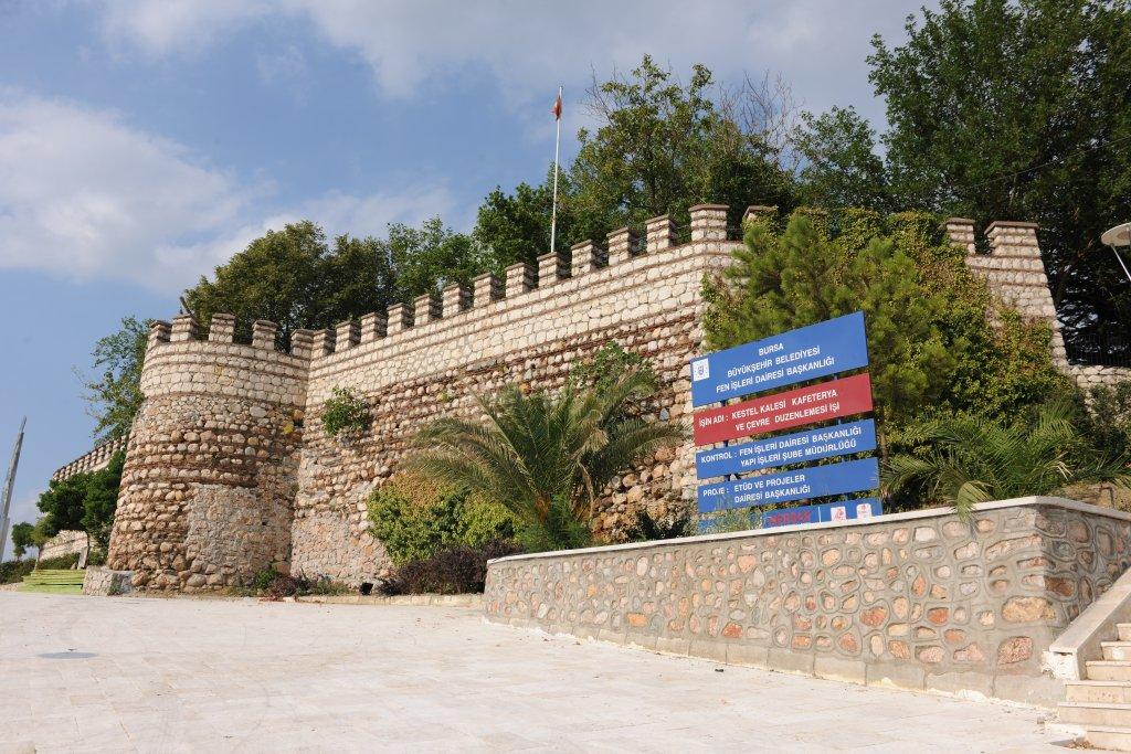
Kestel Kalesi (Bursa Tourism Portal)
Historically, Kestel Kalesi is a historic structure located approximately 12 kilometers east of the center of Bursa province. It was constructed during the Byzantine period to protect Bursa from incursions from Asia. The name “Kestel” derives from the Latin word “Castel,” referring to the castle.
After being incorporated into Ottoman territory in 1306, the castle retained its strategic importance during the Ottoman period. However, after Kestel became a district, it lost its function as a frontier fortress. Today, much of the castle has been destroyed, and its ruins reflect the region’s historical legacy.
Kestel Kalesi remains an important part of the region’s defensive history and cultural heritage.

Vani Mehmet Efendi Camisi (Kestel Municipality)
The Vani Mehmet Efendi Camii and its külliye are among the most significant historical structures remaining from the Ottoman period in Kestel. Commissioned by Şeyhülislam Mehmet Vani Efendi, who was born in the Hoşap kazası of Van, the complex was built after Mehmet Vani Efendi completed his education and held important positions in the imperial court. Following his participation in the Second Siege of Vienna, he was exiled to Kestel by order of Sultan Mehmed IV.
The külliye originally consisted of a mosque, imaret, bakery, madrasa, flour mill, and bathhouse. Today, only the Vani Mehmet Efendi Camii and the bathhouse remain. Within the mosque’s courtyard lies the türbe of Mehmet Vani Efendi. This külliye played a vital role in transforming Kestel into a settlement center and in fostering the development of social life.
Kestel lies at an average elevation of 155 meters above sea level, with terrain generally characterized by mountainous topography. The district contains 24,588 hectares of forested land. The predominant tree species include pine, oriental beech, and chestnut. Agricultural land covers approximately 15,652 hectares, with the majority of land outside forests and settlements used for farming.
Climatically, Kestel lies within a temperate and humid zone, exhibiting transitional characteristics between continental and Mediterranean climates. The warmest month is August, and the coldest is January. The annual average precipitation is 759.4 kg/m². The district lies within a first-degree earthquake zone, with the plain areas particularly vulnerable to seismic risk.

Kestel Organize Sanayi Bölgesi (District Governorship of Kestel, Republic of Türkiye)
Kestel has a cosmopolitan structure, hosting a wide variety of migrant groups. The district’s population was approximately 526 in 1927, rising to 15,239 in 1990, 27,496 in 2000, and 37,282 in 2009. This population growth was significantly influenced by migrants from the Balkans (Bulgaria, Greece, Bosnia-Herzegovina), Eastern Anatolia, and the Black Sea region. The ethnic composition of neighborhoods and villages varies: some are predominantly migrant, while others have a higher proportion of native residents.
Kestel holds a significant position in both industry and agriculture. More than half of the district’s land area consists of first-class agricultural land, allowing for three harvests per year. The agricultural sector employs approximately 25 percent of the district’s population. Agricultural production is dominated by vegetable and fruit cultivation, with major products including pear, strawberry, blackberry, peach, cherry, and apple.
Animal husbandry also plays an important role in the district’s economy. Livestock products such as milk, meat, eggs, honey, and yogurt are prominent. Kestel is one of Türkiye’s key centers for fruit sapling production. Fruit sapling cultivation, which began in 1942, and the development of outdoor ornamental plant production over the last two decades have made significant contributions to the local economy. Approximately 200 sapling producers operate in Kestel, most of which are small family enterprises.
The industrial sector employs approximately 75 percent of the district’s population. Since the 1980s, industrial development has concentrated in major centers including the Kestel Organized Industrial Zone, Kestel 2nd Industrial Zone, Barakfakih Industrial Zone, and Turan Village Industrial Zone. The district hosts over 300 industrial establishments.
Throughout history, Kestel has occupied a strategic location, serving as a frontier fortress during the Ottoman and pre-Ottoman periods. Today, it is a key center in eastern Bursa, marked by significant developments in industry, agriculture, and tourism. With its natural resources, agricultural output, and industrial facilities, Kestel continues to contribute to the regional economy. Sustainable development policies are essential to address urbanization challenges such as seismic risk and the need for urban renewal.
Accessed November 26, 2025.
Accessed November 26, 2025.
Accessed November 26, 2025.
Accessed November 26, 2025.
Bursa Valiliği. Kestel. Accessed June 23, 2025.
Bursa.com.tr. Kestel Kalesi. Accessed June 23, 2025.
Kalkınma Kütüphanesi. Kestel İlçe Raporu. Accessed June 23, 2025.
Kestel Belediyesi. Kültür. Accessed June 23, 2025.
Kestel Belediyesi. Tarihi Merkez / Vani Mehmet Efendi Camisi. Accessed June 23, 2025.
Kestel Belediyesi. Tarihçe. Accessed June 23, 2025.
Kestel Kaymakamlığı. Bursa’nın Güneşi Kestel’den Doğar. Accessed June 23, 2025.
Kestel Kaymakamlığı. Ekonomi. Accessed June 23, 2025.
Kestel Kaymakamlığı. Tarihçe. Accessed June 23, 2025.

Province(s) | Bursa | ||||||||
|---|---|---|---|---|---|---|---|---|---|
Population | Approximately 72,439 (2021) | ||||||||
Area(s) | 423 km² | ||||||||
Climate(s) | Transition between humid temperate and Mediterranean climates continental | ||||||||
District Governor | Recep Öztürk | ||||||||
Mayor(s) | Ferhat Erol | ||||||||
History
Cultural and Touristic Values
Geographical and Natural Structure
Population and Migration
Economic Structure
