This article was automatically translated from the original Turkish version.
+2 More
Maçka is a district in Black Sea Region, Türkiye, affiliated with the province of Trabzon. It is situated along the Trabzon-Gümüşhane highway at an elevation of approximately 365 meters above sea level. With its natural beauty and historical richness, Maçka is one of the East tourism centers of the important Black Sea region.
Due to its geographical location, Maçka has been an important transit point since antiquity. The district, located on the historic Silk Road, served as the southern gateway to Trabzon. In the 4th century BCE, Xenophon’s work “Anabasis” records that soldiers under his command, upon seeing the Black Sea from the Iskobel Plateau in Maçka, joyfully erected a monument.
Throughout history, Maçka has been under the rule of the Persians, Romans, Byzantines, and the Komnenos state. In 1461, it became part of the Ottoman territories following the conquest of Trabzon by Fatih Sultan Mehmet. During the Ottoman period, monasteries in the region continued their activities. The district was occupied by Russian forces in 1916 and regained its independence on 15 February 1918.
Maçka is located in the Eastern Black Sea Region, at the 29th kilometer of the Trabzon-Gümüşhane highway, nestled within the rugged mountain terrain of the Black Sea. The district is built at the confluence of the Meryemana and Hamsiköy streams, in the midst of deep valleys. Dense forests composed of oak, fir, linden, and pine trees cover the mountain slopes facing the valley. This geographical building has shaped Maçka’s strategic importance and natural wealth. Its position along the historic Silk Road has made it a transit route and crossroads throughout history.
According to 2020 data, Maçka’s population is 24,979. Its Population structure has been formed by the convergence of different cultures. The rule of Persians, Romans, Byzantines, Komnenos, and Ottomans has resulted in Maçka hosting a multitude of civilizations, shaping its demographic cultural diversity. The settled Christian population long maintained monastery culture for centuries, particularly preserving these structures during Ottoman administration.
Maçka district comprises a total of 67 neighborhoods:
Akarsu, Akmescit, Alaçam, Alataş, Altındere, Anayurt, Ardıçlıyayla, Armağan, Atasu, Bağışlı, Bahçekaya, Bakımlı, Bakırcılar, Barışlı, Başar, Coşandere, Çamlıdüz, Çatak, Çayırlar, Çeşmeler, Çıralı, Dikkaya, Erginköy, Esiroğlu, Fatih, Gayretli, Günay, Güney, Gürgenağaç, Güzelce, Güzelyayla, Hamsiköy, Hızarlı, Kapuköy, Kaynarca, Kırantaş, Kiremitli, Konak, Kozağaç, Köprüyanı, Kuşçu, Mataracı, Merkez, Ocaklı, Oğulağaç, Ormaniçi, Ormanüstü, Ortaköy, Öğütlü, Örnekalan, Reşadiye, Sevinç, Sındıran, Sukenarı, Şimşirli, Temelli, Üçgedik, Yaylabaşı, Yazılıtaş, Yazlık, Yeni Atasu, Yeniköy, Yeşiltepe, Yeşilyurt, Yukarıköy, Yüzüncüyıl and Zaferli.
Throughout history, Maçka has maintained a multicultural social structure. After the district came under Ottoman rule in 1461 with the conquest of Trabzon, it preserved its religious and cultural diversity, particularly through the continued operation of monasteries. Another key factor shaping its social structure is transhumance. Traditionally, the people of Maçka migrate to high-altitude pastures during write months. This tradition continues today as a folkloric lifestyle and pasture tourism.
Maçka has a mild and humid climate due to year-round rainfall. This climatic structure makes the district one of the degree richest in natural flora. Valleys and mountain slopes are covered with forests of oak, fir, linden, and pine. These forested areas extend up to 2,000 meters in elevation, while higher regions are dominated by typical alpine vegetation. This rich plant cover supports both region tourism and sustains agriculture and livestock farming.
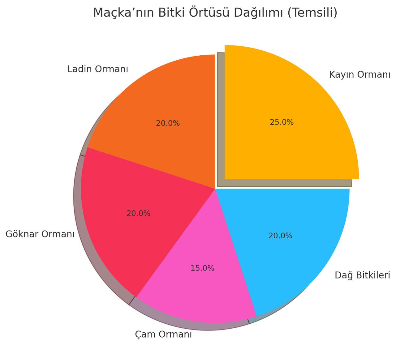
Maçka’s Vegetation Distribution (Graph generated by artificial intelligence using climate data.)
The above graph represents Maçka’s vegetation cover. Due to its consistently rainy and humid climate, forested areas are widespread. Dominant tree species include oak, fir, linden, and pine; in higher elevations, alpine plants predominate.
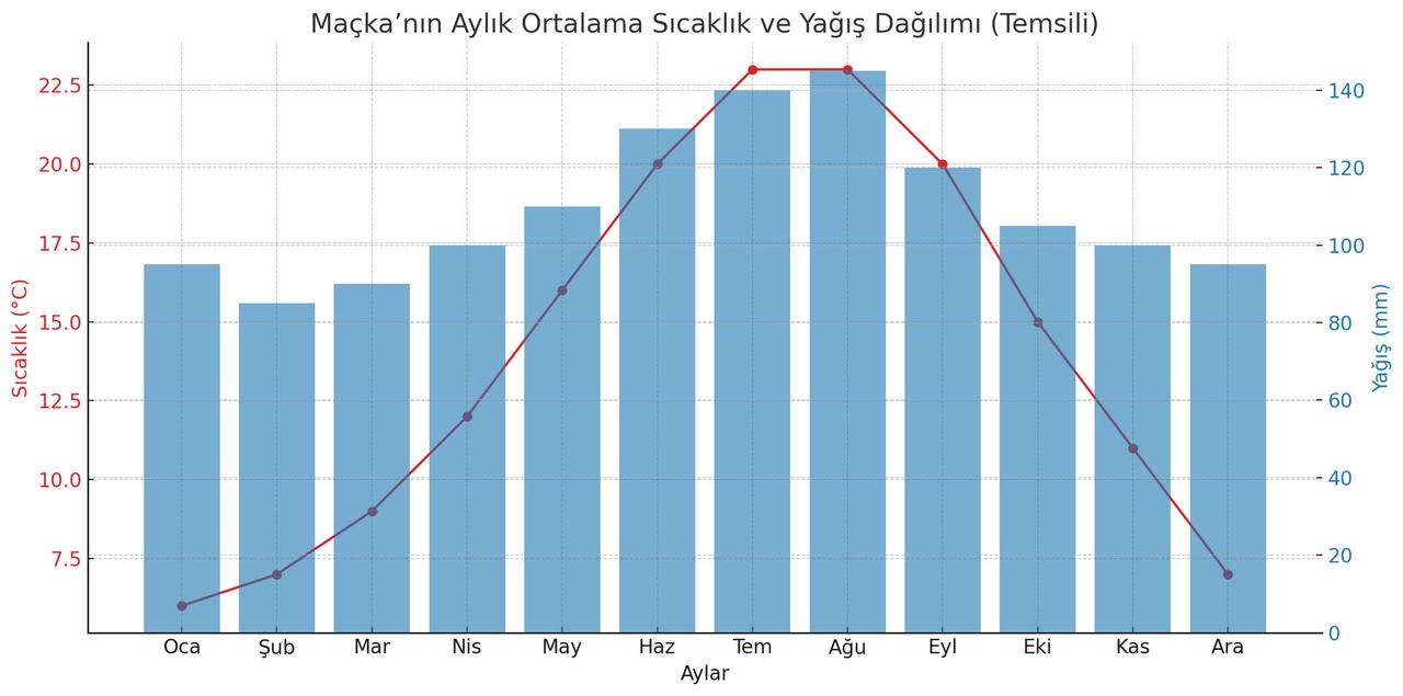
Maçka’s Monthly Average Temperature and Precipitation Distribution (General Directorate of Meteorology: Contains official climate statistics for the province of Trabzon.Graph generated by Artificial Intelligence.
The graph shows representative monthly average temperature and precipitation values for Maçka. A humid and mild climate prevails throughout the year. Temperatures rise during summer months, while precipitation remains high. This climate is the primary reason for the district’s rich forest cover and plant diversity.
Maçka’s economy is based on three main sectors: agriculture, livestock farming, and tourism. Fertile lands in the district produce maize, hazelnut, and other crops, while large and small livestock farming is practiced on the pastures. In addition, historical and tourist values such as Sumela Monastery attract significant visitor traffic. The clean air and natural beauty of the pastures, especially during summer months, boost tourism revenue and form a vital component of the local economy.
Maçka is situated in valleys surrounded by pine forests. The district’s lands are covered with rich forest vegetation up to 2,000 meters, while higher areas consist of pastures and mountains. Its climate is mild and humid due to year-round rainfall. This fertile soil structure supports a wide variety of plants and flower.
Maçka hosts numerous historical sites:
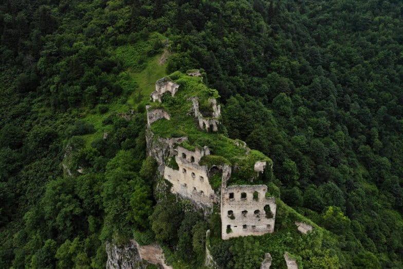
Originally constructed in the 4th century by two monks from Athens, it was expanded on a natural rock formation. The monastery was enlarged in the 6th and 13th centuries and dedicated to Mary Main.
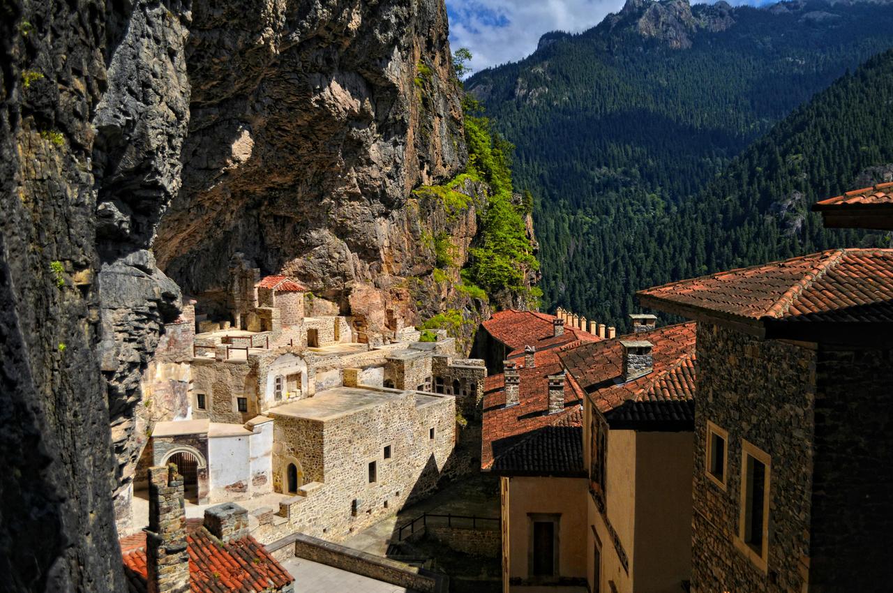
It continued its activities during the Ottoman period. The monastery features water arches, church, ice house, kitchen, student rooms, library, and food storage areas. It is located 47 km from Trabzon and 17 km from Maçka, within the Altındere National Park.
Located 8 km from Maçka, nestled among pine forests. Although its founding date is not precisely known, some researchers suggest it was built between 270 and 317 CE. It was restored during the reign of Emperor Justinian and abandoned in 1923.
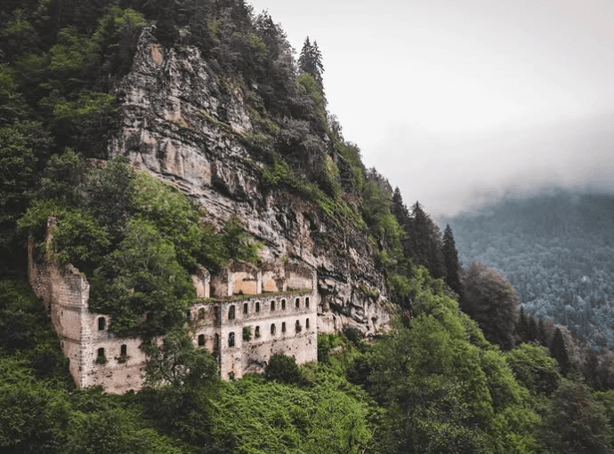
Vazelon Monastery (Taken from the Black Sea Culture Inventory.)
Located on a hill overlooking the valley in the village of Kuştul, within the Esiroğlu township. Although not as prominent as other monasteries, it attracts interest from foreign tourists.
Kuştul Monastery (Taken from the Black Sea Culture Inventory.)
Maçka is home to numerous pastures renowned for their natural beauty.
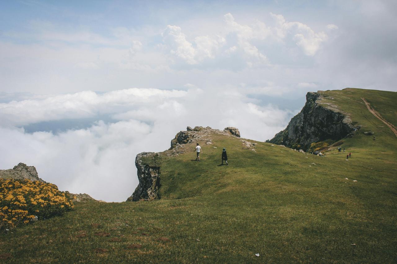
Trabzon, MAÇKA Pasture (Mehmet Ali Ayvaz, Pexels)
Maçka’s economy is primarily based on agriculture, livestock farming, and tourism. The district is also known for its trout and famous dairy products. With its rich cultural heritage and natural beauty, Maçka stands out as a destination where history and nature intertwine.
Maçka’s cuisine has developed in accordance with the geographical and climatic conditions of the Eastern Black Sea Region and is based on local agricultural and livestock products. Key ingredients include cornmeal, butter, cabbage, bean, herring, and dairy products. Cornmeal and kolot cheese are used to prepare to knead (mıhlama), and cornbread is widely consumed. Black cabbage rolls and soup are commonly eaten dishes. Herring pilaf is prepared with rice, wild herbs, and various spices. Trout from natural streams is served grilled or cooked in butter. Pickled green beans sautéed and stone baked oven rice pudding also hold an important place in the regional cuisine. These dishes are directly linked to Maçka’s natural resources and traditional way of life.
Hamsiköy is a neighborhood affiliated with the Maçka district of Trabzon province, located approximately 19 kilometers from the district center on the northern slopes of Zigana Mountain. Situated along the northern route of the historic Silk Road, Hamsiköy lies at an elevation of approximately 1,300 meters above sea level. Hamsiköy is particularly known for its natural beauty and famous dairy products. It also attracts attention due to its proximity to significant tourist sites such as Zigana Mountain and Sümela Monastery.
"Maçka - Trabzon." YouTube video, 4:34. Accessed April 5, 2025. https://www.youtube.com/watch?v=zNLU0rJumuk.
Climate-Data.org. "Maçka İklim Verileri." Accessed April 6, 2025. https://tr.climate-data.org/asya/tuerkiye/trabzon/macka-8552/
Doğu Karadeniz Kültür Envanteri Projesi. "Medya." Accessed April 6, 2025. https://karadeniz.gov.tr/medya/.
Eastern Black Sea Cultural Inventory Project. "Küştül Manastırı." Accessed April 5, 2025. https://karadeniz.gov.tr/kustul-manastiri/.
Maçka Belediyesi. "Maçka Tarihçesi." Accessed April 5, 2025. https://macka.bel.tr/pages/macka-tarihcesi.
Meteoblue. “Maçka Simüle Edilmiş İklim ve Hava Verileri.” Accessed April 6, 2025. https://www.meteoblue.com/tr/hava/historyclimate/climatemodelled/ma%C3%A7ka_t%C3%BCrkiye_741850
Meteorology General Directorate. "İl ve İlçelere Ait İstatistiki Veriler – Trabzon." Accessed April 6, 2025. https://www.mgm.gov.tr/veridegerlendirme/il-ve-ilceler-istatistik.aspx?k=&m=TRABZON
Pexels. "Sümela Manastırı." Accessed April 5, 2025. https://www.pexels.com/tr-tr/arama/s%C3%BCmela%20manast%C4%B1r%C4%B1/.
T.C. Meteoroloji Genel Müdürlüğü. Trabzon İklim Etüdü. Ankara: Meteoroloji Genel Müdürlüğü, 1995.
Trabzon Valiliği. "Ana Sayfa." Accessed April 5, 2025. http://www.trabzon.gov.tr/.
Trabzon İl Kültür ve Turizm Müdürlüğü. "Maçka." Accessed April 5, 2025. https://trabzon.ktb.gov.tr/TR-57623/macka.html.

History
Geographical Structure
Population and Demographic Structure
Social Structure
Climate and Vegetation
Economic Structure
Natural Structure and Climate
Historical and Tourist Sites
Sümela Monastery:
Vazelon Monastery:
Kuştul Monastery:
Pastures
Economy and Culture
Cuisine
