


This article was automatically translated from the original Turkish version.
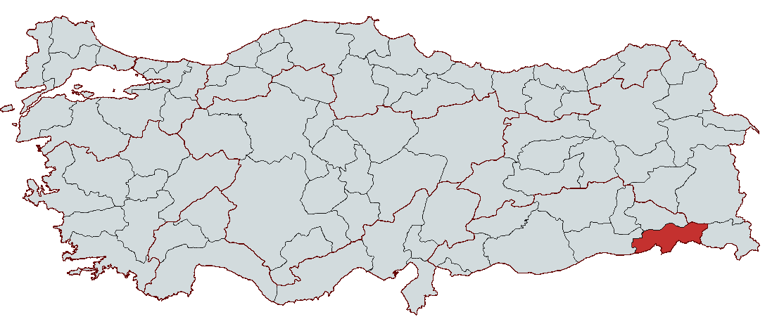
Şırnak
Region | Southeastern Anatolia Region | ||||||||
|---|---|---|---|---|---|---|---|---|---|
Surface Area | 7,172 km² | ||||||||
Elevation | 1,375 m | ||||||||
Neighboring Provinces | Mardin, Siirt, Van, Hakkâri | ||||||||
Border Neighbors | Iraq, Syria | ||||||||
Population (2023) | 570,745 | ||||||||
Historical Structures | Cizre Castle, Finik Castle, Hamidiye Barracks | ||||||||
Religious Tourism | Cizre Grand Mosque, Tomb of Prophet Noah, Tomb of Mem and Zin | ||||||||
Prominent Personality | Al-Jazari (1136–1206), pioneer of robotics | ||||||||
Governor | Birol Ekici | ||||||||
Mayor | Mehmet Yarka | ||||||||
Şırnak is a province located in southeastern Türkiye, distinguished by its historical and cultural depth, natural beauty, and strategic location. Situated at the crossroads of Mesopotamia, Iran, and Anatolia, it has attracted the interest of numerous civilizations throughout history and emerged as a significant settlement center. Since ancient times, Şırnak has served as a home to many cultures. During the Ottoman period, it was a district subordinate to Siirt, and in 1990 it attained provincial status, becoming Türkiye’s 73rd province.
Şırnak carries traces of diverse cultures throughout history and is also regarded as an important religious and cultural center due to the belief that Prophet Noah’s Ark came to rest on Mount Cudi. In addition to religious tourism, the city attracts attention through its historical structures and natural beauty, and in recent years it has gained prominence due to developments in the energy sector.
Despite its mountainous and rugged terrain, Şırnak possesses significant economic diversity through fertile agricultural lands, extensive pasture areas, and border trade. The discovery of oil reserves on Mount Gabar has transformed Şırnak into one of Türkiye’s most important energy centers, reshaping its economic structure.

【1】
Şırnak province lies in southeastern Türkiye, although part of its territory extends into eastern Türkiye. It is situated along the extensions of the Southeastern Taurus Mountains, on the southwestern slopes of Namaz Mountain. Throughout its historical development, this region at the intersection of Mesopotamia, Iran, and Anatolia came under the control of numerous civilizations. However, historical records mentioning the name Şırnak do not appear before the late 19th century; during that period it was known only as a village. Before attaining provincial status, Şırnak was a district under Siirt and became Türkiye’s 73rd province by Law No. 3647 dated 16 May 1990.
The history of settlement in Şırnak and its surroundings extends back to around 7000 BCE. However, limited archaeological excavations in the region have made it difficult to obtain definitive information about the prehistoric period. Nevertheless, as a transitional zone between Mesopotamia and Anatolia, the region was dominated by numerous civilizations including the Sumerians, Subartians, Gutians, Hurrians, Mitanni, Babylonians, Assyrians, and Urartians.
Şırnak, maintaining close relations with Mesopotamian civilizations, held a significant strategic position especially during the Assyrian and Babylonian periods. From the 7th century BCE onward, raids by nomadic groups such as the Cimmerians and Scythians were recorded in the region. Later, it came under the control of the Medes and subsequently the Persian Empire.
Following Alexander the Great’s campaigns in the 4th century BCE, the region fell under Macedonian rule and was later controlled by the Seleucids after his death. During the Roman and Byzantine periods, Şırnak remained an important frontier region and served as a battleground in the conflicts between the Byzantine and Sassanian Empires.
The region came under Islamic rule during the caliphate of Ömer. In 639 CE, Islamic armies under the command of Iyaz ibn Ghanm conquered southern Eastern Anatolia and incorporated Şırnak and its surroundings into Abbasid authority. Under Islamic rule, the region was attached to the Diyarbekir district of the al-Jazira province.
Throughout the Middle Ages, Şırnak and its surroundings came under the control of various states:
In 1514, following Sultan Yavuz Selim’s Çaldıran Campaign, Safavid dominance in the region ended and Şırnak was incorporated into Ottoman territory.
Under Ottoman administration, Şırnak became part of the Siirt Sanjak within the Diyarbekir Eyalet. After the proclamation of the Tanzimat Decree and the transition to the Ottoman provincial system, Şırnak was attached to the Bitlis Vilayet in 1884. Until the late 19th century, Şırnak remained a small village within the Eruh kazas of Bitlis Vilayet.
In the final years of the Ottoman Empire, Sultan II. Abdülhamid established the Hamidiye Regiments and formed military units from local tribes loyal to the Ottoman state. The transition to a settled lifestyle in Şırnak also accelerated significantly during this period.
In the early years of the Republic, Şırnak continued as a district under Siirt province. According to the 1925–1926 State Yearbook of the Republic of Türkiye, Şırnak gained independent district (kaza) status after separating from Eruh district of Siirt.
During this process, the districts of İdil, Cizre, and Silopi from Mardin and the district of Güçlükonak from Siirt were attached to Şırnak. Its population, which stood at 25,059 upon attaining provincial status in 1990, rose to 54,302 by 2007.
There are various theories regarding the origin of the name Şırnak. Known in the 19th century as the name of a tribe, Şırnak was also recorded in Ottoman documents as Şîrhâr. However, according to a widespread local tradition, the name is said to derive from the story of Noah’s Flood. According to the narrative in Surah Hud of the Qur’an, Noah’s Ark came to rest on Mount Cudi, and those who survived the flood established settlements there. It is claimed that this settlement was originally called Şehr-i Nuh and gradually evolved into Şarnah, then Şırnek, and finally Şırnak. However, these claims are not supported by historical documents.
Şırnak is a strategic province located at the intersection of southeastern and eastern Türkiye, characterized by a mountainous and rugged topography with high mountains, deep valleys, and wetlands fed by the Tigris River. A continental climate prevails throughout the province, while the southern districts experience a hotter and drier climate. The vegetation cover is predominantly steppe and oak forests in mountainous areas.
Şırnak province is located in southeastern Türkiye, bordered by Syria and Iraq to the south, Mardin to the west, Siirt to the north, Van to the northeast, and Hakkâri to the east. Its geographic coordinates lie between 37º31’ north latitude and 42º28’ east longitude. With a total area of 7,172 km², the province lies at the intersection of the Southeastern Anatolia and Eastern Anatolia regions.
Şırnak is situated at a key junction of major transportation routes. The road connecting Siirt to Hakkâri intersects with roads linking Mardin to Hakkâri, and these routes also connect the al-Jazira plains to the Eastern Anatolian highlands and further to Azerbaijan.
The elevation of the provincial center above sea level is approximately 1,375 meters, and the terrain is mountainous and rugged. Administratively, Şırnak consists of seven districts along with the central district:
A large portion of Şırnak consists of high mountains belonging to the Southeastern Taurus system. Mountain peaks in the region rise above 3,000 meters in places. The most significant elevations are:
Except for some plains in the western and southern areas, the province features deep valleys and plateaus shaped by rivers. The Tigris River is the province’s most important water source; other major rivers include Kızılsu Çayı, Habur Çayı, and Hezil Çayı. The main valleys are Dicle, Kızılsu, Behram, and Habur Valleys.
The climate in Şırnak varies according to elevation and geographic location. In the higher elevations, a harsh continental climate typical of Eastern Anatolia prevails, while other areas experience a continental climate.
The average annual precipitation in Şırnak is approximately 633 mm. Drought is distinctly felt during summer months, while winter months bring heavy rainfall and snowfall.
Şırnak’s vegetation cover, shaped by the continental climate, consists of steppe and sparse forests in mountainous areas. Due to the harsh and dry climate, the natural vegetation is predominantly composed of steppe plants.
Agricultural land is limited, but extensive plains in Cizre, Silopi, and İdil districts are suitable for agricultural production.
According to data released by the Turkish Statistical Institute (TÜİK), as of 31 December 2023, Şırnak’s population was recorded at 570,745. This population consists of 296,978 males and 273,848 females, meaning males constitute 52.03% and females 47.97% of the total population.
Şırnak ranks among Türkiye’s provinces with the highest proportion of young population. In 2023, Hakkâri had the highest youth population percentage at 21.5%, while Şırnak and Siirt shared second place at 21.1%.
The average household size in the province is 4.86 persons, the highest in Türkiye. This indicates the prevalence of extended family structures in Şırnak.
The population distribution across Şırnak’s districts is as follows:
These figures reveal that Şırnak has a young and dynamic population, with families typically organized in extended structures and a pronounced distribution of population across districts.
Şırnak is a city notable for its deep history and rich cultural heritage. Known as the city of Prophet Noah, Şırnak was a center during the Ottoman period for renowned poets who wrote in Kurdish within Classical Islamic literature. Some poets were born and spent their entire lives here, while others lived here for a period. The city has served as a home to many civilizations throughout history and left behind significant architectural works during this process.
Şırnak and its surroundings have hosted numerous important structures throughout history. The province’s most significant cultural assets include:

【2】
Şırnak is an important center for religious tourism. Many narratives associate the story of Noah’s Flood with Mount Cudi. In this context, the Tomb of Prophet Noah in Cizre and the ship-shaped Cizre Walls are regarded as supporting elements of this belief. Additionally, places of worship and tombs in the city hold significant value for religious tourism:
Cizre has produced important figures not only in religious and historical fields but also in science and technology. One such figure is al-Jazari. This great scientist, who lived in the 12th century, invented numerous automatic machines and made groundbreaking contributions to the field of robotics.
Şırnak continues to be an important center through its historical heritage, potential for religious tourism, and cultural diversity.
Faraşin Highland in Beytüşşebap district stands out for its rich vegetation and natural beauty. The highland provides an ideal environment for beekeeping and small-scale livestock farming. It is also suitable for hiking, ecotourism, and flora tourism.

【3】
Şırnak attracts attention with its rich nature tourism areas. The province’s mountains, rivers, and valleys offer significant potential for outdoor sports and ecotourism.
The region is also rich in wildlife. Many wild animals such as foxes, hares, partridges, ducks, geese, and cranes live in Şırnak’s natural areas. In this respect, Şırnak holds significant potential for nature tourism and hunting tourism.
The Hesta-Belkısana Thermal Baths in Güçlükonak and the Zümrüt Thermal Baths in Beytüşşebap are important sites for thermal tourism. These spas are beneficial for treating rheumatic diseases, orthopedic conditions, and skin disorders.
Şırnak cuisine stands out for its rich and diverse dishes.
Perde Pilavı, a traditional dish made with chicken meat and almonds.
Hekeheşandi, a type of pilaf made with minced meat and eggs.
Kipe, a dish made by stuffing sheep intestines with minced meat and rice.
Meyre (Mehir), a yogurt-based dish prepared with ayran, dövme, and vegetables.
Şırnak is a city where economic activities are concentrated in various sectors including agriculture, livestock, industry, mining, and border trade. In recent years, the discovery of oil on Mount Gabar has created a major transformation in Türkiye’s energy strategy and established Şırnak as one of the country’s most important oil production centers. In addition, the region’s agricultural and livestock production capacity and the potential of border trade form the fundamental dynamics of Şırnak’s economy.
Şırnak possesses significant potential for agriculture and livestock due to its extensive agricultural land and favorable climatic conditions. Twenty-two percent of the province’s land is agricultural, 39% is forested, and 15% consists of meadows and pastures. These figures indicate the availability of vast areas suitable for agricultural and livestock activities.
Agriculture: Agriculture is a major economic activity in Şırnak. The main agricultural products grown in the province include:
Livestock: Livestock farming, especially small ruminant breeding, is widespread in Şırnak. The region’s geographic structure and extensive pasture areas are key supporting factors for this sector. Meat and milk production are significant, while beekeeping also draws attention. Wool, hair, leather, and egg production also contribute to the regional economy. Support projects are being implemented to enhance livestock farming, with the goal of increasing production capacity.
Beekeeping: Honey production is an important economic activity in Şırnak. Annual honey production reaches 603 tons, and this volume is expected to increase significantly under favorable conditions. In 2018, an investment of 37 million TL was made in livestock and agriculture support projects.

【4】
Although the industrial sector in Şırnak is less developed compared to agriculture and services, significant investments have been made in mining and energy in recent years.
a) Industrial Structure
b) Organized Industrial Zones (OIZ)
Şırnak has two Organized Industrial Zones (OIZ):
1. Şırnak OIZ (76 hectares, 8% occupancy rate)
2. Cizre OIZ (82 hectares, 42% occupancy rate)
Additionally, studies are ongoing to establish small industrial sites in Silopi and İdil.
The most significant development in recent years that has positioned Şırnak strategically on Türkiye’s energy map is the discovery of oil on Mount Gabar. Oil exploration activities initiated in 2021 have enabled the region to become a major energy center.
a) Data on Türkiye’s Largest Oil Discovery
These figures demonstrate that Gabar oil has become one of Türkiye’s most productive fields.
b) Contribution to Türkiye’s Economy
c) Impact on Local Economy and Employment

【5】
Şırnak is a city located in southeastern Türkiye with access via both road and air transport. Although its geographic structure limits transportation networks, recent infrastructure projects have improved mobility.
Road Transport: Şırnak is connected to surrounding provinces via road networks. The Şırnak–Cizre Road is one of the province’s most important routes, linking Şırnak to Cizre, the region’s commercial center. In addition, the Şırnak–Van and Şırnak–Siirt roads provide connections to the east and north.
The region’s mountainous terrain occasionally causes delays in transportation, especially during winter months. However, recent road widening and improvement projects have enhanced road safety.
Air Transport: Air access to Şırnak is provided through Şerafettin Elçi Airport. Opened in 2013, the airport is located near Cizre and İdil districts and offers regular flights to major cities such as Istanbul and Ankara.
Border Gate and International Transport: Şırnak has one of Türkiye’s most important trade points through the Habur Border Gate with Iraq. Habur, one of Türkiye’s busiest land border crossings, is of great importance for both passenger and freight transport. A large portion of trade with Iraq passes through this border gate, making it a hub for logistics activities.
Rail and Sea Transport: Şırnak has no rail or sea transport infrastructure. However, with the development of industry and logistics in the region, rail projects are expected to be addressed in the coming years.
Public administration in Şırnak is carried out by two main governing bodies: the governorship and the municipality. The governorship represents central government, while the municipality manages local services.
The Şırnak Governorship is a central government body operating under the Ministry of Interior. The governor is appointed by the President of the Republic and is responsible for the overall administration of the province. The governorship’s duties include maintaining public order, implementing security services, coordinating public services such as education, health, and transportation, and implementing state policies locally. On 19 September 2024, Birol Ekici was appointed as governor of Şırnak by the Decree of Governors.
Şırnak Municipality functions as the local administrative body. The mayor, along with the municipal council and executive committee, is responsible for planning and implementing local services. The mayor and municipal council members are elected by the public and serve as representatives of the local population. In the local elections held on 31 March 2024, AK Party candidate Mehmet Yarka was elected mayor with 18,033 votes, securing 47.58% of the vote.
Cizre Gazetesi. "Şırnak’ın Nüfusu Açıklandı." Accessed February 18, 2025.https://cizremgazetesi.com/yasam/sirnakin-nufusu-aciklandi-sirnak-nufusu-uzun-suredir-buyuk-merak-konusuydu-32912.html.
Devlet Hava Meydanları İşletmesi (DHMİ). "Şırnak Şehir Tarihçesi." Accessed February 18, 2025.https://www.dhmi.gov.tr/Sayfalar/Havalimani/Sirnak/SehirTarihcesi.aspx.
Ministry of Culture and Tourism. "Finik Kalesi." Accessed February 18, 2025.https://www.kulturportali.gov.tr/turkiye/sirnak/gezilecekyer/fnk-kales.
Ministry of Culture and Tourism. "Şırnak Doğa Turizmi." Accessed February 18, 2025.https://sirnak.ktb.gov.tr/TR-371266/doga-turizmi.html
Ministry of Culture and Tourism. "Şırnak Genel Bilgiler." Accessed February 18, 2025.https://www.kulturportali.gov.tr/turkiye/sirnak/genelbilgiler.
Ministry of Culture and Tourism. "Şırnak Kültür Turizmi." Accessed February 18, 2025.https://sirnak.ktb.gov.tr/TR-371273/kultur-turizmi.html.
Ministry of Culture and Tourism. "Şırnak Termal Turizmi." Accessed February 18, 2025.https://sirnak.ktb.gov.tr/TR-371291/termal-turizm.html.
Ministry of Culture and Tourism. "Şırnak Yayla Turizmi." Accessed February 18, 2025.https://sirnak.ktb.gov.tr/TR-371265/yayla-turizmi.html.
Ministry of Culture and Tourism. "Şırnak İnanç Turizmi." Accessed February 18, 2025.https://sirnak.ktb.gov.tr/TR-371290/inanc-turizm.html.
TRT Haber. "Gabar’da Günlük Petrol Üretimi 75 Bin Varile Ulaştı." Accessed February 18, 2025.https://www.trthaber.com/haber/ekonomi/gabarda-gunluk-petrol-uretimi-75-bin-varile-ulasti-895676.html.
TRT Haber. “Şırnak Seçim Sonuçları Açıklandı – 31 Mart 2024 Yerel Seçimleri.” Accessed February 18, 2025.https://www.trthaber.com/haber/guncel/sirnak-secim-sonuclari-aciklandi-31-mart-2024-yerel-secimleri-846427.html
Tuncel, Metin. “Şırnak.” Türkiye Diyanet Vakfı İslam Ansiklopedisi. Accessed February 18, 2025.https://islamansiklopedisi.org.tr/sirnak.
Türkiye İstatistik Kurumu (TÜİK). "CIP - Coğrafi İstatistik Portalı." Accessed February 18, 2025.
İletişim Başkanlığı. “Şırnak Enerji Sektöründe Öne Çıkıyor.” Accessed February 18, 2025.https://www.iletisim.gov.tr/turkce/yerel_basin/detay/sirnak-enerji-sektorunde-one-cikiyor.
Şırnak Belediyesi. "Şırnak." Accessed February 18, 2025.https://www.sirnak.bel.tr/sirnak/.
Şırnak Valiliği. "Tarihçe." Accessed February 18, 2025.http://www.sirnak.gov.tr/tarihce.

Şırnak
Region | Southeastern Anatolia Region | ||||||||
|---|---|---|---|---|---|---|---|---|---|
Surface Area | 7,172 km² | ||||||||
Elevation | 1,375 m | ||||||||
Neighboring Provinces | Mardin, Siirt, Van, Hakkâri | ||||||||
Border Neighbors | Iraq, Syria | ||||||||
Population (2023) | 570,745 | ||||||||
Historical Structures | Cizre Castle, Finik Castle, Hamidiye Barracks | ||||||||
Religious Tourism | Cizre Grand Mosque, Tomb of Prophet Noah, Tomb of Mem and Zin | ||||||||
Prominent Personality | Al-Jazari (1136–1206), pioneer of robotics | ||||||||
Governor | Birol Ekici | ||||||||
Mayor | Mehmet Yarka | ||||||||
History
Ancient Era and Early Settlements
Islam and the Medieval Period
Ottoman Period
Republican Era and Provincial Status
Etymology
Geography
Location and General Features
Topography
Climate
Vegetation Cover
Demographic Structure
Culture and Tourism
Historical Structures and Cultural Heritage
Religious Tourism
Scientific and Cultural Heritage
Highland Tourism
Nature Tourism
Thermal Tourism
Traditional Cuisine
Economy
Agriculture and Livestock
Industry and Mining
Energy Sector and Oil Production
Border Trade and Habur Border Gate
Transportation
Governance