


Bu içerik Türkçe olarak yazılmış olup yapay zeka ile otomatik olarak İngilizceye çevrilmiştir.
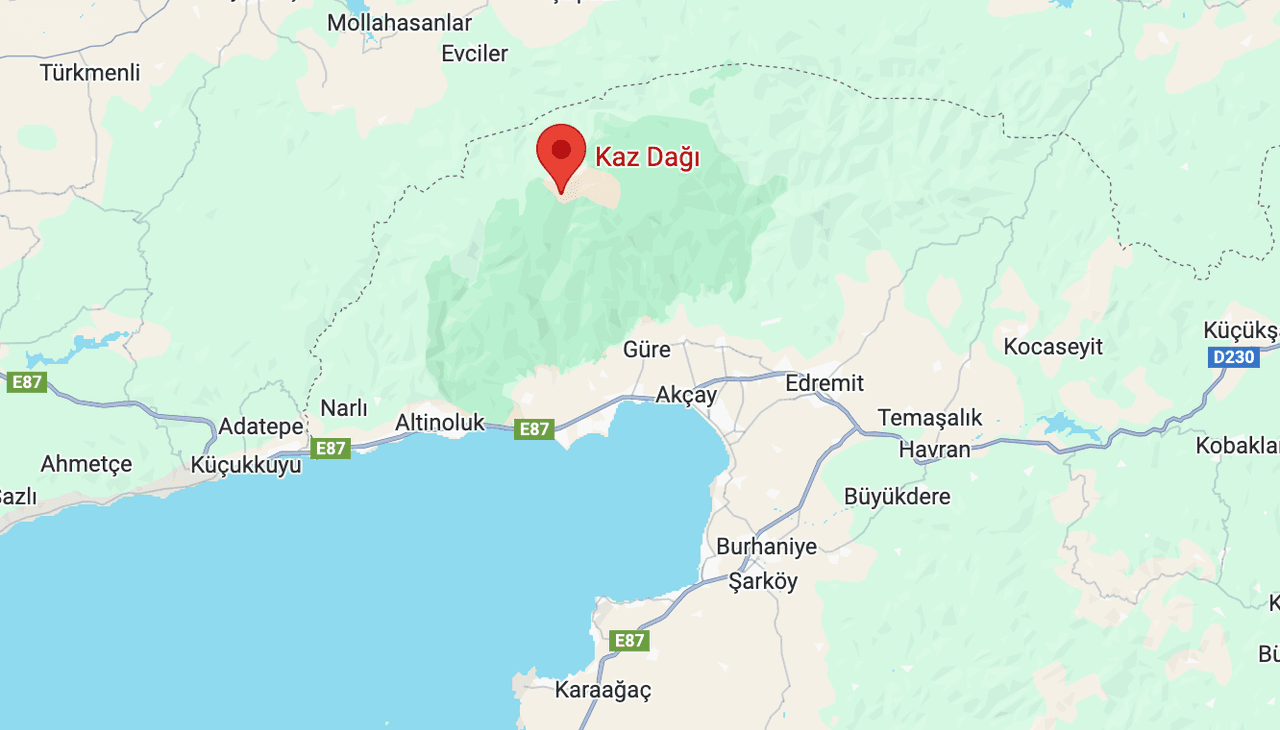
Kaz Dağları Map
Name in Mythology | İda Dağı | ||||||||
|---|---|---|---|---|---|---|---|---|---|
Geographical Location | In the northwestern part of Türkiye Between the provinces of Balıkesir and Çanakkale | ||||||||
Highest Point and Elevation | Karataş Hill (1774 metres) | ||||||||
Edremit Bay's northern side is home to the Kaz Dağları, which span an area of 21,300 hectares and lie in northwestern Türkiye between the provinces of Balıkesir and Çanakkale. This mountain range forms the highest points of the Biga Peninsula. The ancient name of the Kaz Dağları is "İda Dağı", a Greek name from antiquity (Ἴδη – Ida). The region attracts attention due to its natural richness and its mythological and historical significance. The Kaz Dağları constitute the highest point of the Biga Peninsula, with its highest peak, Karataş Tepesi, reaching 1,774 meters. The mountains form a boundary between the Marmara and Aegean regions and lie at the intersection of the Mediterranean and Black Sea climates.

Kaz Dağları, 2024 (Fotoğraf: Melike Erol)
The Kaz Dağları extend in an east-west direction and are located north of the Edremit Bay. The region is surrounded by rich water sources, deep valleys, and canyons. The Şahindere Canyon is the most well-known of these natural formations. The mountains rise from sea level to 1,774 meters, and this elevation creates a convergence of different climate types. This diversity enhances the region’s biological richness.
In Homer’s Iliad, Mount Ida (Kaz Dağı) is described as “the mother of wild animals with abundant springs.” Springs emerge throughout the Kaz Dağları, including year-round water sources even at elevations of 1,500 meters. The icy cold drinking and usage water for Edremit, Akçay, and Altınoluk originates from the melting snows of the Kaz Dağları. When the forest air from the Kaz Dağları combines with the iodine-rich, high-oxygen air of the sea, the Altınoluk Şahindere Strait and its surroundings are described as an “oxygen tent.” This location has been identified as one of the top three places in the world for oxygen abundance.

Kaz Dağları, (Türkiye Kültür Portalı)
The Kaz Dağları are exceptionally rich in plant diversity due to their location between the Europe-Siberia and Mediterranean phytogeographical regions. Over 800 plant species are found in the region, approximately 70 of which are endemic. The Kazdağı Fir (Abies equi-trojani) is a unique species found only in this area. Other common tree species include Turkish pine, black pine, oak, chestnut, beech, and hornbeam.
The Kaz Dağları host a rich variety of animal life. Species found in the region include wild boar, fox, jackal, wolf, badger, hedgehog, squirrel, chamois, and numerous bird species. The presence of endemic and rare species further enhances the region’s biological importance.
The Kaz Dağı has been home to various civilizations since prehistoric times. Known historical settlements date back to around 2000 BCE. Cities such as Thebe, Lyrnessos, Khrysa, Killa, Anderia, Antandros, Adramytteion, Astrya, and Gargara were established during this period, many of which were destroyed during the Trojan Wars.
The Kaz Dağları have been the subject of numerous myths and legends since antiquity. Mount Ida (Kaz Dağı) is known worldwide as the Mountain of Myths and Legends. Three major legends are associated with the Kaz Dağları: one is the Greek legend (the Iliad), and the other two are Turkish legends—those of Sarıkız and the love story of Hasan and Emine.
In Greek mythology, this is the site where Paris awarded the Golden Apple to Aphrodite, triggering the first beauty contest in history. As is well known, the consequences of this contest led to the famous Trojan War.
In 1993, an area of 21,452 hectares was declared the Kaz Dağı National Park. The park extends from Zeytinli Çayı to Altınoluk on the northern shore of the Edremit Bay. Natural attractions within the park include the Sütüven Waterfall, Hasanboğuldu Reservoir, and the Şahindere Canyon. Walking trails, picnic areas, and observation terraces are available for visitors. However, access to certain areas is restricted to protect the environment, and guided visits are recommended.
The Sütüven (Hasanboğuldu) waterfall, located 4.5 km from the village of Zeytinli, was established in 1992. The Hasanboğuldu reservoir, situated at the foot of the Kaz Dağları and fed by the Kızılkeçili Stream, along with the 17-meter-high Sütüven waterfall, has become increasingly popular in recent years. During the summer season, visitor numbers approach 100,000.

Hasanboğuldu Reservoir (Sütüven)
The Kaz Dağları constitute an important area requiring conservation due to their biological diversity and ecosystem services. With their natural beauty, rich biodiversity, and historical significance, they are one of Türkiye’s most valuable ecosystems.
Kaz Dağı National Park, (TRT 4K)
The climate of the Kaz Dağları is predominantly Mediterranean, with hot, dry summers and cold, rainy winters. These climatic conditions directly influence the vegetation and agricultural activities in the region. The east-west orientation of the mountains creates microclimatic differences between the northern and southern slopes. Northern slopes experience lower average annual temperatures and higher precipitation, while southern slopes are warmer and receive less rainfall.
The Kaz Dağları are known as “Mount Ida of a Thousand Springs” and host countless streams, springs, and rivers. Streams such as Zeytinli, Kızılkeçili, Hasanboğuldu, and Mıhlı serve as the lifeblood of the regional ecosystem. These water sources support the ecological balance and meet agricultural and drinking water needs.
Balıkesir Valiliği. "Kaz Dağları." Accessed May 15, 2025.http://www.balikesir.gov.tr/kaz-daglari
Balıkesir İl Directorate of Culture and Tourism. "Kaz Dağları (İda Dağı)." Ministry of Culture and Tourism of the Republic of Turkey. Accessed May 15, 2025.https://balikesir.ktb.gov.tr/TR-65922/kaz-dagi-ida-dagi.html
Culture Portal. "Kaz Dağı (İda Dağı)." Ministry of Culture and Tourism of the Republic of Türkiye. Accessed May 15, 2025. https://www.kulturportali.gov.tr/turkiye/canakkale/gezilecekyer/kaz-dagi-da-dagi124208.
Doğa Derneği. "Kaz Dağları." Accessed May 15, 2025.https://dogadernegi.org/kaz-daglari/.
Forest General Directorate. "Kaz Dağları Biyoçeşitlilik ve SürdürülebilirOrman Genel Projesi GEF Konsey Onayını Aldı." Date Published: May 17, 2022. Accessed May 15, 2025.https://www.ogm.gov.tr/tr/haberler/kaz-daglari-biyocesitlilik-ve-surdurulebilir-orman-yonetimi-projesi-gef-konsey-onayini-aldi
Hasanboğuldu Doğal Beauties. "Photo Gallery." Hasanboğuldu Natural Beauties and Nature Park Official Website. Accessed May 15, 2025.https://www.hasanboguldu.com/fotograf-galerisi/#group.
Kültür ve Yaşam. "10 Madde ile Kaz Dağları – Dağlarda Geçen Efsaneler." Accessed May 15, 2025.https://kulturveyasam.com/10-madde-ile-kaz-daglari-daglarda-gecen-efsaneler/
Ministry of Agriculture and Forestry. "Kaz Dağları Korunan Alan Bilgisi." Accessed May 15, 2025.https://ekotaban.tarimorman.gov.tr/alan/54
Tarım TV. "Doğaseverler Kaz Dağları’nı Ekoturizm Rotasıyla Keşfedecek." Date Published: November 3, 2021. Accessed May 15, 2025.https://www.tarimtv.gov.tr/tr/video-detay/dogaseverler-kaz-daglari-ni-ekoturizm-rotasiyla-kesfedecek-17300

Kaz Dağları Map
Name in Mythology | İda Dağı | ||||||||
|---|---|---|---|---|---|---|---|---|---|
Geographical Location | In the northwestern part of Türkiye Between the provinces of Balıkesir and Çanakkale | ||||||||
Highest Point and Elevation | Karataş Hill (1774 metres) | ||||||||
Henüz Tartışma Girilmemiştir
"Kaz Dağları" maddesi için tartışma başlatın
Geography and Climate
Flora
Fauna
History and Mythology
Kaz Dağı National Park
Climate and Hydrography