


This article was automatically translated from the original Turkish version.
+2 More
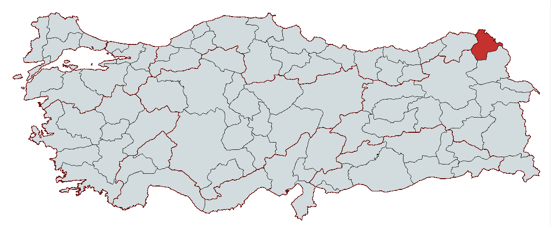
Ardahan
Country | Türkiye | ||||||||
|---|---|---|---|---|---|---|---|---|---|
Region | Eastern Anatolia Region | ||||||||
Population | 91,354 (2023) | ||||||||
Area | 5,576 km² | ||||||||
Climate | Continental Climate | ||||||||
Important Structure | Ardahan Merkez Mevlit Efendi Cami Çıldır Lake Ardahan Castle | ||||||||
Area Code(s) | 478 | ||||||||
License Plate Code | 75 | ||||||||
Governor | Hayrettin Çiçek | ||||||||
Mayor | Faruk Demir | ||||||||
Ardahan, located in the northeast of Türkiye, has a deep historical past marked by traces of various civilizations. With a history spanning approximately 3,000 years, this region has served as an important settlement center for numerous civilizations due to its strategic position opening toward Caucasus. Ardahan has been under the rule of major states such as the Seljuks, the Ottomans, and the Russians, and during the War of Independence it became a key theater of major battles. Regaining its provincial status in 1992, Ardahan continues to stand out as one of Türkiye’s notable provinces through its natural beauty, economy based on agriculture and livestock, volcanic landscape, and historical remnants.
Ardahan province has a history of approximately 3,000 years and bears traces of various civilizations throughout time. The region was first conquered in 628 AD by the Arda Turks, a branch of the Khazars, and this conquest gave rise to the name Ardahan. The name derives from the settlement of the Arda Turks in these lands. Ardahan’s strategic importance made it an attractive location for numerous civilizations throughout history.
In 1068 AD, following the victories of Great Seljuk Sultan Alp Arslan against the Byzantines, Ardahan was incorporated into Seljuk territories. After the Seljuks’ rule, the Ottoman Empire formally annexed the region in 1555 through the Treaty of Amasya. During the Ottoman period, Ardahan was administered for many years as a district subordinate to Kars. In the late 19th century, as a result of the Russo-Ottoman War (93 War), the 1878 Treaty of Berlin ceded Ardahan to the Russian Empire, initiating nearly 40 years of Russian rule.
Russian rule ended in 1918 with the Treaty of Brest-Litovsk, and Ardahan was reintegrated into the territory of the Republic of Türkiye. However, this transition occurred during a period of dense Armenian and Georgian populations, and the local Turk population faced harsh conditions including ethnic cleansing and occupation. The National Council Government, established on 30 October 1918, rejected the Armistice of Mudros and initiated steps toward the independence struggle. Ardahan’s participation in the War of Independence culminated in victory when the Turkish army under the command of Kazım Karabekir Paşa and Halit Paşa recaptured Ardahan on 23 February 1921. Kazım Karabekir Paşa emphasized the region’s strategic importance, stating, “The Straits are our straits, Kars-Ardahan is our backbone,” affirming Ardahan’s critical role for Türkiye.
After the proclamation of the Republic, Ardahan was downgraded to a district of Kars province in 1926. However, its status as a province was restored on 27 May 1992 through Law No. 3806, granting it an independent administrative structure.
Ardahan’s historical journey highlights the vital role the region played in the Turkish nation’s struggle for existence. Ottoman and Russian rule, the War of Independence, and subsequent developments have reinforced Ardahan’s strategic and cultural significance.
Ardahan is located in the Eastern Anatolia Region of Türkiye, and is also near the eastern part of the Black Sea Region. The province borders Georgia to the north, and Georgia and partially Armenia to the east. It is surrounded by Kars to the southeast, Erzurum to the south, and Artvin to the west. Ardahan holds strategic geographical importance as Türkiye’s gateway to the Caucasus.
Ardahan province covers an area of 5,576 km² and consists of six districts: Damal, Göle, Hanak, Posof, Çıldır, and Merkez. The central district includes seven municipalities and 39 neighborhoods, along with 227 villages. The province’s geography is characterized by high and rugged mountains that largely shape its natural landscape.

Ardahan (Source:Pexels/The KRM)
To the north of the province lie the Yalnızçam Mountains; to the east, Akbaba Mountain and Keldağ; to the southeast, the Allahuekber Mountains and Kısır Mountain. The Ardahan Plain, covering much of the province, is a high plateau with an average elevation of 1,800 meters. The highest point in Ardahan is the peak of Kısır Mountain, rising to 3,197 meters. Other significant mountains include Akbaba Mountain at 3,126 meters and Keldağ at 3,033 meters.
Ardahan’s natural structure features volcanic and tectonic characteristics. The Göle Basin is enriched with alluvial deposits forming marshes and meadows. The Ardahan Basin is a large depression surrounded by high mountains. Çıldır and Aktaş lakes form significant tectonic basins, with their surroundings composed of volcanic and sedimentary terrain.
In addition to its high mountains and rugged terrain, Ardahan’s rich natural structure provides habitats for diverse ecosystems. This geographical diversity plays a crucial role in both agricultural and livestock activities. Furthermore, Ardahan’s geomorphological structure offers an ideal environment for outdoor activities such as mountaineering and hiking.
Ardahan’s economy is largely shaped by agriculture and livestock, while industry and tourism sectors show more limited development. Due to its geographical conditions, economic activities in these sectors rely heavily on traditional methods. Livestock and agriculture are the main pillars of the provincial economy, while industrial activities remain limited.
The province’s extensive pastures and meadows, rich in vegetation, provide favorable conditions for livestock farming. Cattle and sheep are the most commonly raised animals. The mor and ak Karaman breeds are prevalent in sheep farming, while the Eastern Anatolian Red, Vezavod, and Kalakan breeds dominate cattle rearing. Beekeeping is also a well-developed sector. Ardahan is particularly known for dairy production, with these products marketed to major cities such as Istanbul and Ankara.
Agricultural activities are primarily carried out along riverbanks. Due to climatic conditions resembling the Mediterranean climate—with cold winters and dry summers—crops such as wheat, barley, rye, and small quantities of potatoes are cultivated. However, arable land suitable for field farming is limited, and productive agricultural areas are generally concentrated in regions where irrigation is feasible.
The industrial sector in Ardahan has not developed significantly. The largest enterprise in this sector is Karset, a company producing livestock-based products. Additionally, the province hosts milk collection centers and small-scale dairies. Although manufacturing industry has not been a primary driver of economic growth, recent increases in investment and the establishment of industrial zones have accelerated industrialization. Food and beverage production holds the largest share in Ardahan’s industrial sector, with production also occurring in metal products and wood-mushroom products. Nevertheless, the industrial sector’s contribution to the provincial economy remains well below the national average.
In recent years, various projects have been initiated to improve transportation infrastructure in Ardahan. These projects aim to enhance the efficiency of both intra-city and inter-city transportation. Efforts focused on expanding and upgrading existing roads seek to reduce traffic congestion and shorten travel times. The addition of new routes will facilitate intra-city mobility and provide the region with a more robust transportation network.
Innovations in public transportation are designed to provide faster and more comfortable travel. The introduction of new vehicles and modern bus lines aims to increase passenger capacity, while smart ticketing systems are being implemented to streamline transportation processes. These changes aim to increase public transportation usage and reduce private vehicle use.

Ardahan Castle and Bridge (Source: Ardahan Municipality)
Hayrettin Çiçek is currently serving as the Governor of Ardahan, having been appointed on 9 August 2023 by Presidential Decree No. 2023/376.
Ardahan Ticaret of Commerce and Industry. "Anasayfa." Accessed February 15, 2025.https://www.ardahantso.org.tr/
Ardahan Valiliği. "Anasayfa." Accessed February 15, 2025.http://www.ardahan.gov.tr/.
Ministry of Culture and Tourism. "Genel Bilgiler." Accessed February 15, 2025.https://www.kulturportali.gov.tr/.
Ministry of Culture and Tourism. "Yöre Mutfağı – Gastronomi." Accessed February 15, 2025.https://ardahan.ktb.gov.tr/TR-55769/yore-mutfagi-gastronomi.html.
Tutar, Hüseyin, Gökhan Elyıldırım, Mehmet Fatih Sever, and Mustafa Sarışen. Ardahan’ın Sosyo-Ekonomik Durumu ve Uygun Yatırım Alanları. February 2013.
Şehrim Ardahan. "Ardahan’daki Ulaşım Problemleri Çözülüyor: Yeni Altyapılar ve Toplu Taşımacılık." Accessed February 15, 2025.https://sehrimardahan.com/tr-ardahan-son-dakika-haberleri/ardahan-daki-ulasim-problemleri-cozuluyor-yeni-altyapilar-ve-toplu-tasimacilik/89466.

Ardahan
Country | Türkiye | ||||||||
|---|---|---|---|---|---|---|---|---|---|
Region | Eastern Anatolia Region | ||||||||
Population | 91,354 (2023) | ||||||||
Area | 5,576 km² | ||||||||
Climate | Continental Climate | ||||||||
Important Structure | Ardahan Merkez Mevlit Efendi Cami Çıldır Lake Ardahan Castle | ||||||||
Area Code(s) | 478 | ||||||||
License Plate Code | 75 | ||||||||
Governor | Hayrettin Çiçek | ||||||||
Mayor | Faruk Demir | ||||||||
History
Geographical Structure
Economic Structure
Livestock
Agriculture
Industry
Transportation and Infrastructure
Tourism
Historical Structures
Local Cuisine
Local Administration
Governor