

This article was automatically translated from the original Turkish version.
+1 More
Kastamonu
Country | Türkiye | ||||||||
|---|---|---|---|---|---|---|---|---|---|
Region | Black Sea Region | ||||||||
Population | 381991 | ||||||||
Area | 13064 km² | ||||||||
Climate | North: Black Sea Climate / South: Continental Climate | ||||||||
Important Structure | Mahmut Bey Camii Liva Paşa Konağı Etnografya Müzesi Şeyh Şaban-ı Veli Külliyesi Nasrullah Camii Kastamonu Kalesi | ||||||||
Governor | Meftun Dallı | ||||||||
Mayor | Hasan Baltacı | ||||||||
Area Code(s) | 366 | ||||||||
License Plate Code | 37 | ||||||||
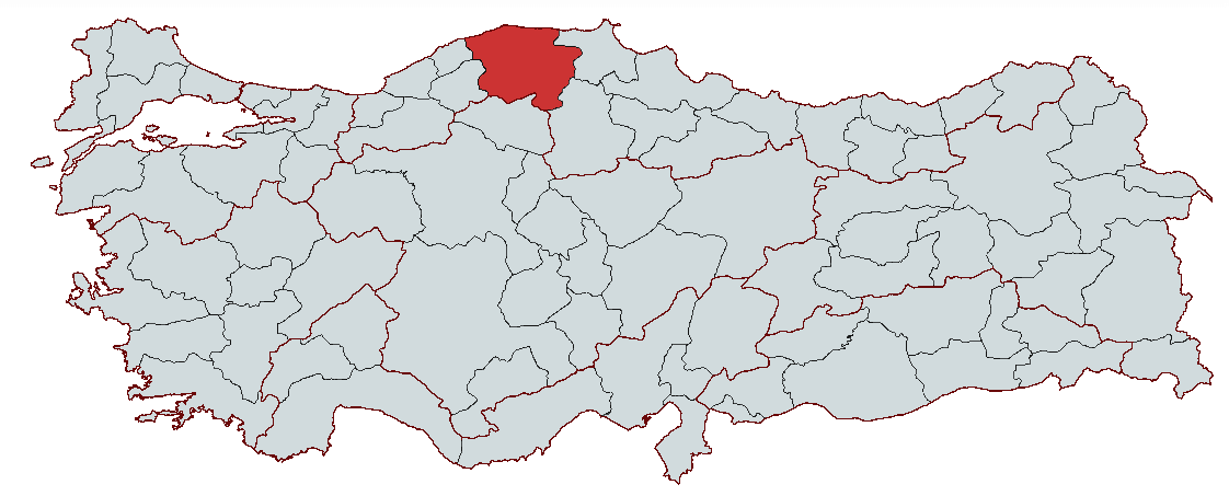
Kastamonu is a city located in the Black Sea Region of Türkiye that has served as a home to various civilizations throughout history. Geographically, the city stretches along the valley of Karaçomak Creek on the northern slopes of the Küre Mountains and lies at an elevation of approximately 780 meters above sea level. Since ancient times, it has been under the rule of numerous civilizations including the Hittites, Phrygians, Lydians, Persians, Romans, and Byzantines, and was conquered by Turks beginning in the 11th century. During the Seljuk and Ottoman periods, Kastamonu became an important center of trade and culture, particularly developing as the capital of the Candaroğulları Beylik. The city features significant historical structures such as Kastamonu Castle, Nasrullah Camii, Mahmut Bey Camii, and Şeyh Şaban-ı Veli Türbesi. Its climate exhibits characteristics of the Black Sea climate in the north and continental climate in the south, and the provincial economy is based on agriculture, forestry, and animal husbandry.

Ilgaz Dağları
There are various theories regarding the origin of the name Kastamonu, but none have been definitively proven. The most prominent etymological approaches are as follows:
Kaskians and Tumanna Theory
Some researchers suggest that the name Kastamonu is linked to the Kaskians, who inhabited the region during the Hittite period. Hittite texts refer to a settlement named “Tumanna” or “Tummana” in the area where Kastamonu is located. It is therefore believed that the term Gastumanna, meaning “City of the Kaskians,” gradually evolved into Kastamonu.
Byzantine Era and Kastra-Komnen Theory
Another theory holds that Kastamonu derives its name from the Byzantine Empire. The combination of the Latin word “Kastra” (meaning castle) and “Komnen” (a Byzantine dynasty name) gave rise to the name Kastra-Komnen, which over time transformed into Kastamonu. This theory is based on the strategic importance of castles in the region during the Byzantine period.
Paphlagonia and Ancient Period Theory
Some researchers believe that the name Kastamonu originates from the ancient region of Paphlagonia. The Paphlagonians, an ancient people who ruled Kastamonu and its surroundings, may have influenced the naming of the region. However, this theory is less widely accepted compared to others.
Hittites and Kastama Theory
Some studies propose that the name Kastamonu evolved from the Hittite-era name “Kastama,” used for the same region. This name appears in Hittite records and is thought to have gradually become Kastamonu over time.
Among these etymological theories, the most widely accepted are the Kastra-Komnen and Kaskians-Tumanna connections. However, there is no definitive information regarding the exact origin of the name Kastamonu.
Kastamonu and its surroundings have hosted numerous civilizations throughout history and played a significant role in the region’s political, economic, and cultural development. The earliest settlement traces extend back to the Paleolithic Era, and archaeological research in the villages of Tahta and Malak has uncovered findings dating to the Middle Paleolithic. Although there are no definitive proofs from the Neolithic period, settlements from the Chalcolithic and Bronze Ages have been identified.
During the Hittite period, Kastamonu was part of a region known as Tum(m)ana and served as a battleground in conflicts between the Kaskians and Hittites. After the collapse of the Hittite Empire, the region came under the control of the Phrygians, followed by the Cimmerians and Lydians. In 546 BCE, Kastamonu and its surroundings were captured by the Persians and incorporated into the third satrapy of the Persian Kingdom. In 334 BCE, following Alexander the Great’s campaign in Anatolia, the region became part of the Macedonian Kingdom. However, after Alexander’s death, it fell under the dominion of the Kingdom of Pontus. Following conflicts between Rome and the Kingdom of Pontus, Kastamonu came under Roman control in 64 BCE.

Çatak Kanyonu
After the division of the Roman Empire in 395, Kastamonu became part of the Eastern Roman (Byzantine) Empire. The region remained under Byzantine administration for a long period, during which structures such as Kastamonu Castle were built. Following the Battle of Manzikert in 1071, the Turks began spreading across Anatolia, and Kastamonu became a target for Turkish tribal leaders. From 1084 onward, Emir Karategin, subordinate to Süleyman Şah, briefly seized control of the region. However, the Byzantines recaptured Kastamonu, and the area remained a site of Byzantine-Turk conflicts until the 12th century.
With Danışmend Gazi’s conquest of Kastamonu in the early 12th century, Turkish presence in the region became permanent. In 1196, Kastamonu and its surroundings were incorporated into the Anatolian Seljuk State. During this period, the Çobanoğulları Beylik, centered in Kastamonu and led by Hüsameddin Çoban, was established (1227–1309). Under Çobanoğulları rule, mosques, caravanserais, and bridges were constructed, and Kastamonu became an important trade center.
After the Çobanoğulları, Kastamonu passed to the Candaroğulları Beylik in 1309. The Candaroğulları established long-lasting dominance in Kastamonu and Sinop. During this period, maritime activities gained particular importance, and Sinop became a shipyard center. In 1383, relations with the Ottomans strengthened, but in 1391, the city was incorporated into Ottoman territory following a campaign by Yıldırım Bayezid.
After coming under Ottoman rule, Kastamonu became first a sanjak and later an eyalet center. Following Yıldırım Bayezid’s defeat by Timur in the Battle of Ankara (1402), the region briefly returned to the Candaroğulları. However, Fatih Sultan Mehmed definitively ended the Candaroğulları Beylik in 1461 to consolidate unity in Anatolia, fully integrating Kastamonu into Ottoman lands. During the Ottoman period, Kastamonu became one of Anatolia’s key administrative and military centers. Evliya Çelebi noted that in the 17th century, Kastamonu was a major city notable for its mosques, caravanserais, and markets. In the 19th century, Kastamonu became an important node in Black Sea trade, and various industries developed in the city.
During the War of Independence, Kastamonu played a vital role in Anatolia’s resistance movements. The port of İnebolu became a crucial center for smuggling arms and ammunition from Istanbul to Anatolia. Figures such as Şerife Bacı made great sacrifices to support the front. The people of Kastamonu actively participated in the National Struggle under the leadership of Mustafa Kemal Atatürk. With the proclamation of the Republic, Kastamonu became an important site in the modernization process. In 1925, Atatürk visited Kastamonu and initiated the Hat Revolution, leading the modernization movement. Today, Kastamonu continues to exist as a city renowned for its historical heritage, natural beauty, and cultural values.

Ilıca Şelalesi
Kastamonu is a province located in the western section of Türkiye’s Black Sea Region. It borders Sinop to the east, Çorum to the southeast, Çankırı to the south, Karabük and Bartın to the west, and the Black Sea to the north. The province covers an area of 13,064 km², placing it among the larger provinces of Türkiye by surface area.
Kastamonu’s geographical structure is mountainous and rugged. The Ilgaz Mountains lie to the south and the Küre Mountains to the north, both extending parallel to the Black Sea. The highest point is Çatalılgaz Hill at 2,565 meters. Mountainous areas cover a large portion of the province, limiting accessibility and arable land.
Valleys and plateaus between the mountains also shape the province’s geography. Notably, the plains of Devrekani, Araç, and Taşköprü are significant areas suitable for agriculture.
Kastamonu has numerous rivers. The most important is Gökırmak, a tributary of the Kızılırmak River. Other significant rivers include Karaçomak Creek, Devrekani Creek, Ilgaz Creek, and Araç Creek.
Lake resources are limited in Kastamonu, but there are some small lakes and reservoirs such as Yedigöller, Ilgaz Reservoir, Karaçomak Dam, and Devrekani Dam.
Kastamonu has a coastline of approximately 170 kilometers along the Black Sea, making it one of the provinces with the longest Black Sea shoreline in Türkiye. Districts such as Cide, İnebolu, and Abana are located along the coast and feature natural beaches and coastal ecosystems. Along the Black Sea coast, cliffs and coves are common.
Two distinct climate types are observed in Kastamonu:
The Küre Mountains block moist air from the Black Sea from reaching the interior, resulting in the interior regions receiving less influence from the Black Sea climate.
Kastamonu is one of Türkiye’s provinces with the largest forested area, with approximately 67% of its surface covered by forests. The Küre Mountains National Park is recognized as one of Europe’s most important biodiversity conservation areas. Forests are dominated by beech, oak, black pine, Scots pine, fir, hornbeam, and chestnut trees. Along the coast, plane trees, laurel, and chestnut trees are common. In terms of wildlife, Kastamonu is home to species such as brown bear, red deer, wild boar, fox, wolf, lynx, roe deer, and wild boar.

Küre Dağları
Kastamonu’s total population is 381,991. The majority of the population lives in rural areas, and the level of urbanization is lower than the national average. The settlement with the highest population is the provincial center, with 156,638 residents. It is followed by Tosya with a population of 39,401 and Taşköprü with 37,196. The least populated districts are Ağlı with 3,250, Şenpazar with 4,380, and Abana with 4,419.
Kastamonu’s total population is 381,991, distributed among the provincial center and districts as follows:
Kastamonu has been among the provinces experiencing significant emigration since the second half of the 20th century. Particularly large numbers of people of Kastamonu origin reside in major cities such as Istanbul and Ankara. Since the 2000s, the province’s population has fluctuated, with emigration causing declines at times, but internal migration from rural areas to the center has increased the population of the provincial center.
The age distribution in Kastamonu resembles the national average, with a relatively high proportion of elderly residents. Due to its economy based on agriculture and animal husbandry, the youth population in rural areas is declining. A significant portion of the young population migrates to large cities for education and employment opportunities.
Agriculture and animal husbandry form the foundation of Kastamonu’s economy. The province’s extensive farmland and fertile valleys enable the cultivation of various agricultural products. The district of Taşköprü is one of Türkiye’s leading producers of high-quality garlic, and Kastamonu garlic holds a geographical indication certification. Additionally, sugar beet, wheat, barley, maize, beans, apples, and walnuts are significant crops.

Araç Yaylaları
Animal husbandry also plays a major role in the provincial economy. Large and small livestock farming is widespread, with milk and meat production serving as vital sources of livelihood. Beekeeping has also developed, and Kastamonu honey is among the well-known local products in Türkiye.
Kastamonu is one of Türkiye’s provinces with the largest forest coverage, with approximately 67% of its surface area covered by forests. This has enabled the development of forestry and wood industries. Lumber production and furniture manufacturing are major economic activities across the province, with woodworking particularly important as an income source in the districts of Devrekani and İnebolu.
The industrial sector in Kastamonu is limited but has begun to develop in recent years. Kastamonu Integrated Wood Industry is one of the province’s largest industrial enterprises, operating in the wood products and furniture sector. In addition, flour, animal feed, dairy, and food industries have developed.
Mining is also an important sector in the province. Copper mines operate in the district of Küre, and this production is considered one of Türkiye’s significant mineral resources. Additionally, there are quarries for stone and marble throughout the province.
The province’s commercial structure is shaped around agricultural and livestock products. Local products such as garlic, honey, cereals, and wood products hold significant positions in Kastamonu markets. In addition, small-scale commercial enterprises are concentrated in the provincial center. In terms of transportation, Kastamonu is located at a distance from Türkiye’s major trade centers, which limits the development of industry and trade. Kastamonu Airport is an important transportation hub for international trade and tourism, although flight traffic is limited. Road infrastructure projects such as connections to the Black Sea coastal highway and the Ilgaz Tunnel represent significant investments aimed at improving the province’s trade network.
Although Kastamonu has high tourism potential due to its historical fabric, natural beauty, and cultural heritage, the tourism sector has not fully developed. The province is rich in historical structures, natural areas, highland pastures, coastal regions, and faith-based tourism. However, the incomplete development of tourism infrastructure has limited the region’s tourism revenue.
Kastamonu has hosted numerous civilizations from the Hittites to the Ottomans and possesses a rich historical heritage.
Kastamonu is one of Türkiye’s provinces with the largest forested areas and holds great potential for nature tourism.
Kastamonu’s highland pastures are of great importance for nature tourism. Notable pastures, known for their clean air, natural beauty, and local festivals, include:
Kastamonu is one of Türkiye’s important winter tourism centers thanks to Ilgaz Mountain.
Kastamonu has a coastline of approximately 170 kilometers along the Black Sea. However, coastal tourism remains limited. Although the coastal districts have high potential for nature and sea tourism, deficiencies in accommodation and infrastructure hinder tourism development.

Horma Kanyonu
Kastamonu hosts important faith-based centers such as the Şeyh Şaban-ı Veli Türbesi. Additionally, the province has numerous tombs and historical mosques. Key faith-based tourism sites in Kastamonu include:
Various festivals and cultural events are held annually in Kastamonu.
Kastamonu cuisine is a fusion of Black Sea and Central Anatolian cuisines, distinguished by its traditional flavors based on agriculture and animal husbandry. Meat and grain-based dishes form the foundation of Kastamonu cuisine. In addition, products with geographical indication certification and local desserts make Kastamonu one of Türkiye’s most unique cuisines.
Banduma/Islama: A dish made by soaking yufka or erişte pieces in chicken broth and butter, topped with boiled chicken meat and walnuts before serving. Especially prepared in winter months, banduma is one of Kastamonu’s most famous regional dishes.
Etli Ekmek: In Kastamonu, etli ekmek is made by spreading minced or cubed meat on thin unleavened dough and baking it in a stone oven. Unlike the version in Konya, it has a denser dough texture.
Pastırma-Flavored Sour Rice Pilaf: This dish is prepared with beef pastırma, rice, chickpeas, and sour plum juice and is frequently prepared on special occasions in Kastamonu cuisine. Its unique flavor comes from the combination of sourness and pastırma aroma.
Tirit: Tirit is made by soaking stale bread in bone broth and butter, then served with boiled meat and yogurt. A traditional dish prepared especially during weddings and special occasions in Kastamonu.

Kuyu Kebabı
Kuyu Kebabı: A type of kebab prepared by suspending lamb meat in specially dug pits and slow-cooking it over charcoal fire. This dish is commonly prepared in the districts of Tosya and Taşköprü, especially at large gatherings and weddings.
Rice Mantı: Unlike traditional mantı, Kastamonu mantı is filled with rice instead of minced meat and is typically served with yogurt.
Culture Portal. "Kastamonu Genel Bilgiler." Accessed February 13, 2025.https://www.kulturportali.gov.tr/turkiye/kastamonu/genelbilgiler.
Kastamonu Valiliği. "Şehrimiz." Accessed February 13, 2025.http://www.kastamonu.gov.tr/sehrimiz.
Türkiye İstatistik Kurumu. "Dünya Nüfus Günü 2024." Accessed February 13, 2025.https://data.tuik.gov.tr/Bulten/Index?p=Dunya-Nufus-Gunu-2024-53680.
Şahin, İlhan. "Kastamonu." TDV İslâm Ansiklopedisi. Accessed February 13, 2025.https://islamansiklopedisi.org.tr/kastamonu.

Kastamonu
Country | Türkiye | ||||||||
|---|---|---|---|---|---|---|---|---|---|
Region | Black Sea Region | ||||||||
Population | 381991 | ||||||||
Area | 13064 km² | ||||||||
Climate | North: Black Sea Climate / South: Continental Climate | ||||||||
Important Structure | Mahmut Bey Camii Liva Paşa Konağı Etnografya Müzesi Şeyh Şaban-ı Veli Külliyesi Nasrullah Camii Kastamonu Kalesi | ||||||||
Governor | Meftun Dallı | ||||||||
Mayor | Hasan Baltacı | ||||||||
Area Code(s) | 366 | ||||||||
License Plate Code | 37 | ||||||||
No Discussion Added Yet
Start discussion for "Kastamonu (Province)" article
Etymology of the Name Kastamonu
History
Ancient Era and Early States
Byzantine Era and Early Turkish Conquests
Anatolian Seljuks and Beylik Period
Ottoman Period
National Struggle and Republican Period
Geography
Landforms and Mountains
Rivers and Lakes
Coastline and Access to the Black Sea
Vegetation and Natural Life
Population
Population Growth and Migration
Age Distribution
Economy
Agriculture and Animal Husbandry
Forestry and Wood Industry
Industry and Mining
Trade and Transportation
Tourism
Historical and Cultural Tourism
Nature Tourism
National Parks and Canyons
Highland Pastures
Winter Tourism
Coastal Tourism
Faith-Based Tourism
Festivals and Cultural Events
Kastamonu Cuisine